
Acer saccharum (Sugar Maple), bark, mature (3.41389)
Date: August 10 2002Creator: Hedborn Jr., Edward A.
Type: Photographic image
Description:Acer saccharum (Sugar Maple), bark, mature
The Morton Arboretum Inventory & Collections & Cultural Names (3.44609)
Date: April 25 1990Creator: Sidwell Company
Type: Map
Description:Four topographical maps with drawn area boundaries and area names written in marker. Page 5 is missing.
Extent: 4 Sheets

Quercus rubra (Northern Red Oak), bark, mature (3.46760)
Date: November 24 2008Creator: Hedborn Jr., Edward A.
Type: Photographic image
Description:Quercus rubra (Northern Red Oak), bark, mature
Topographical Plat of Portion of Land to be Used for Morton Arboretum, Lisle, Illinois, July 1921 (3.5245)
Date: July 1921Creator: O. C. Simonds & Co.
Type: Map
Description:Each sheet is individually titled. Area covered extends from western boundary eastward to the East Woods. True elevations are given. Native woodland cover is shown, and legend identifies eight species of trees.
Extent: 2 sheets mounted as one map
A Berm Detail for the Morton Arboretum [of the southern boundary] (3.5269)
Date: 1988Creator: Tyznik, Anthony
Type: Map
Description:Revised version of the Western section issued in June, 1988.
Extent: 1 sheet
Revised Plat of Section "B," Morton Arboretum (3.5325)
Date: November 21 1934Creator: Lozier, J. S.
Type: Map
Description:Surveys the area east of Route 53 in the central portion of the Arboretum and extending eastward to the East Woods, a tract totaling 318.996 acres.
Includes notes in red pencil.
Extent: 1 sheet
Revised Plat of Section "B," Morton Arboretum (3.5327)
Date: November 21 1934Creator: Lozier, J. S.
Type: Map
Description:Surveys the area east of Route 53 in the central portion of the Arboretum and extending eastward to the East Woods, a tract totaling 318.996 acres.
Extent: 1 sheet
[Aerial Photograph of the Morton Arboretum, full] (3.5421)
Date: circa 1977Type: Photographic image
Description:Collection has enlargement of the Street Trees Collection (28x35 cm.) appearing in the larger photograph, an area ca. one-quarter mile square located sourth of the King's Grove area.
This object is the full aerial photograph.
Extent: 1 sheet
[Aerial Photograph of the Morton Arboretum, sectional enlargements] (3.5423)
Date: circa 1977Type: Photographic image
Description:These photographs are a sectional enlargement of the Street Trees Collection appearing in the larger photograph, an area ca. one-quarter mile square located south of the King's Grove area.
In marker on back: "TA File # D322. Geo. Ware has prints from color transparencies. Dr. Virgil Howe @ Wn/Illinois (?) has original Infra-red positive transparencies (9 x 9). TMA has set of copy 35mm from early summer 1977 (Street Trees)."
Extent: 2 sheets
[Aerial Photograph of a Portion of the East Half, the Morton Arboretum] (3.5424)
Date: November 7 1974Type: Photographic image
Description:"Photographed from 9,600 feet." Shows the area from Route 53 eastwards through the King's Grove. Grid crosses set out on the ground are visible in the photo. The collection's photograph is an enlargement of one displayed on the second floor of the Administration Building.
Extent: 1 sheet
Morton Arboretum proposed sewer line (3.5625)
Date: 1970sType: Map
Description:Composite aerial survey map (4 sheets) showing the area from Leask Lane eastwards into the King's Grove. Sewer installations proposed and identifying legends have been mounted in the photos.
Extent: 1 sheet
Plan for Caprifoliaceae: Viburnum, Lonicera, Diervilla, Sambucus, Symphoricarpus, Dipelta [and] Kolkwitzia, Morton Arboretum [Simonds plan] (3.5642)
Date: 1923Creator: O. C. Simonds & Co.
Type: Plan
Description:Plantings proposed for an area in the eastern portion of the Arboretum, but never developed according to the Simonds' plan. The projected work did serve as basis for one subsequently developed by Henry Teuscher ( See LAND:C I (a) 1).
Extent: 1 sheet
Plan for Caprifoliaceae: Viburnum, Lonicera, Diervilla, Sambucus, Symphoricarpus, Dipelta [and] Kolkwitzia, Morton Arboretum [Teuscher plan] (3.5644)
Date: 1923Creator: Teuscher, Henry
Type: Plan
Description:Based on plan first done by O.C. Simonds & Co.m titled Plan for Caprifoliaceae: Viburnum, Lonicera, Diervilla, Sambucus, Symphoricarpus, Dipelta [and] Kolkwitzia, Morton Arboretum.
Notes added in ink.
Extent: 1 sheet
The Birch Group [planting plan] (3.5647)
Date: March 21 – June 20 1925Creator: Teuscher, Henry
Type: Plan
Description:Planting plan for the Birch Group in the King's Grove area, including Asiatic, European, and American birches. Also identifies road leading to Caprifoliaceae
Extent: 1 sheet
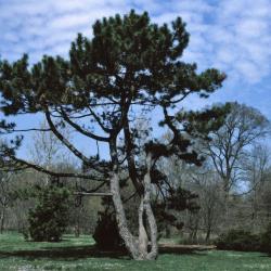
Pinus nigra (Austrian Pine), habit, spring (3.61173)
Date: April 7 1999Creator: Hedborn Jr., Edward A.
Type: Photographic image
Description:Pinus nigra (Austrian Pine), habit, spring
Assessment Plat No.2, Lands Belonging to Trustees Under the Will of Joy Morton, Deceased, Lisle Twp., DuPage County, Illinois (3.6239)
Date: October 1 1934Creator: Lozier, J. S.
Type: Map
Description:Surveys a portion of the King's Grove and surrounding area southward to Warrenville Road.
Extent: 1 sheet
[Aerial Photograph of the Morton Arboretum, sectional enlargements] (3.6562)
Date: circa 1977Type: Photographic image
Description:These photographs are a sectional enlargement of the Street Trees Collection appearing in the larger photograph, an area ca. one-quarter mile square located south of the King's Grove area. Copies 4, 5, 6 from vault 2/99.
Collections A
Extent: 3 sheets
A Berm Detail for the Morton Arboretum [of the southern boundary] [ink drawing on parchment] (3.6763)
Date: February 1986Creator: Tyznik, Anthony
Type: Map
Description:Set of topographic maps giving berm elevations along the East-West Tollway from the Route 53 intersection to the eastern boundary of the Arboretum. Coverage of the area is given as follows: [1] Western section inclusive of the King's grove area; [2] Central section inclusive of the area into the East Woods; [3] Puffer marsh area.
Collection has a revised version of the Western section issued in June, 1988 and a CD scan by Pat Kelsey, 4-18-2006.
Extent: 3 sheets
1990/05/29: Pete Van Der Linden to Gerould Wilhelm (3.81723)
Date: May 29 1990Creator: van der Linden, Peter J.
Type: Document
Description:Memo from Pete van der Linden to Gerould Wilhelm regarding prescribed burning the East Woods.
Extent: 5 sheets