Browsing by people, organizations and landmarks: century:
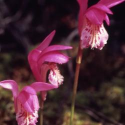
Arethusa bulbosa L. (dragon's mouth orchid), flowers (3.101058)
Date: June 1980Creator: Allen, Kimberly
Type: Photographic image
Description:Arethusa bulbosa L. (dragon's mouth orchid) ,Fun photograph of three flowering Dragon's mouth flower heads, all facing the same direction, basking in the sunshine
Extent: 1 slide
[Soils Mapped on the Schulenberg Prairie of the Morton Arboretum] (3.106096)
Date: circa 1990Creator: Hootman, Rick, Allen, Kimberly
Type: Map
Description:Numbered sections refer to soil series. Appears to be an early draft
Extent: 1 sheet
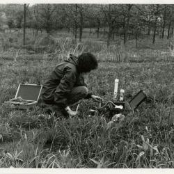
Kim Allen monitoring soil moisture in Schulenberg Prairie (3.4501)
Date: circa 1990Type: Photographic image
Description:Kim Allen monitoring soil moisture in Schulenberg Prairie
Extent: 1 photograph

George Ware Retirement Party in Founders Room - George Ware and Kim Allen (3.4630)
Date: 1994Type: Photographic image
Description:George Ware Retirement Party in Founders Room - George Ware and Kim Allen
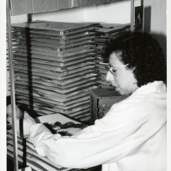
Kim Allen drying a plant specimen in the Herbarium (3.4819)
Date: 1992Type: Photographic image
Description:Kim Allen drying a plant specimen in plant dryer that has been glued to paper in the Herbarium
Extent: 1 photograph
Carlisles Asst. Plat: Lot 1/SE 33, SWD #89-0595, Milton Township (3.5940)
Date: August 10 1989Creator: Allen, Kimberly
Type: Map
Description:Topographic survey and lot survey of "Little House on the Prairie," an Arboretum residence located along Leask Lane.
Extent: 1 sheet
Drainage Swale Topography and Pipeline Cross-sections Along North Edge of Tollway Berm: Centennial Grove to Crabapples (3.6100)
Date: 1989Creator: Allen, Kimberly
Type: Map
Description:Preliminary survey of swale and drain pipe along north end of tollway berms. This was modified in 1991 with the installation of drain tiles.
Extent: 1 sheet
Drainage Swale Topography and Pipeline Cross-sections Along North Edge of Tollway Berm: Centennial Grove to Crabapples (3.6101)
Date: 1989Creator: Allen, Kimberly
Type: Map
Description:Preliminary survey of swale and drain pipe along north end of tollway berms. This was modified in 1991 with the installation of drain tiles. Copy 2 is original elevation numbers and topographic plot (3 sheets).
Extent: 3 sheets
Proposed, Initial, and Final Grades Along Crabapple Lake Swale (3.6103)
Date: July 1989Creator: Allen, Kimberly
Type: Map
Extent: 1 sheet
Topographic Map of Willoway Creek Area Along Schulenberg Prairie by K.A. Altvatter, Richard G. Hootman, and Patrick D. Kelsey [preliminary] (3.6104)
Date: 1989Creator: Allen, Kimberly
Type: Map
Description:# 810 (3.6038) is stamped PRELIMINARY, but it is a duplicate of copy 1, # 876 (3.6104) which is not marked as preliminary. Recorded # 810 as a duplicate in this record.
Extent: 1 sheet
Topographic Map of Willoway Creek Area Along Schulenberg Prairie by K.A. Altvatter, Richard G. Hootman, and Patrick D. Kelsey (3.6105)
Date: 1989Creator: Allen, Kimberly
Type: Map
Description:Individual location elevations.
Extent: 1 sheet
Topographic Map of Willoway Creek Area Along Schulenberg Prairie by K.A. Altvatter, Richard G. Hootman, and Patrick D. Kelsey [ink on mylar] (3.6106)
Date: 1989Creator: Allen, Kimberly
Type: Map
Description:Copy 3 is an ink on mylar topographic map 220 cm x 92 cm (scale is 1 inch = 20 feet).
Extent: 1 sheet
Soils Mapped on the Schulenberg Prairie of the Morton Arboretum (3.6772)
Date: 1990Creator: Hootman, Rick, Allen, Kimberly
Type: Map
Description:Key names of soil series and percent of slopes.
Extent: 1 sheet on board
1992 Annual Report, Research Group (3.81725)
Date: 1992Type: Document
Description:Annual report for the Research Group of the Morton Arboretum which contains a mission statement, group structure, chronology of events, interactions, priorities, and strengths and weaknesses.
Extent: 8 sheets