1982/04/26: Bob Wilson to George Ware (3.80501)
Date: April 26 1982Creator: Wilson, Bob
Type: Document
Description:A set of two documents. The first is a letter from Bob Wilson of the Chicago Research Divers to Dr. George Ware of the Morton Arboretum. The second is an issue of the Chicago Divers' Journal dated April, 1982 and contains the CRD Project Arbor Report.
Extent: 20 sheets
1986/06: Ross Brocato to George Ware (3.70011)
Creator: Brocato, Ross, Delly, John G.
Type: Document
Description:A set of two documents. The first is a letter from Ross Brocato to George Ware. The second is a research report update of the Arbor Lake Diatom Study by Chicago Research Divers dated May, 1986.
Extent: 7 sheets
1986/08/21: Ross Brocato to George Ware (3.69996)
Date: August 21 1986Creator: Brocato, Ross, Delly, John G. , Kelsey, Pat
Type: Document
Description:A set of documents including a letter from Ross Brocato to George Ware, a research paper titled "Mapping Soil pH as an indicator of Disturbance by P.D. Kelsey, and The Arbor Lake Research Report Update for July, 1986.
Extent: 6 sheets
1986/09/07: Ross Brocato to George Ware (3.69995)
Date: September 7 1986Creator: Brocato, Ross, Delly, John G.
Type: Document
Description:A set of two documents. The first is a letter from Ross Brocato of Chicago Research Divers to George Ware. The second document is the Arbor Lake Research Report Update for July, 1986.
Extent: 3 sheets
1988/12/28: Ross Brocato to George Ware (3.69994)
Date: December 28 1988Creator: Brocato, Ross, Delly, John G.
Type: Document
Description:A set of two Documents. The first is a letter from Ross Brocato of NI-TEC describing issues in compiling The Arbor Lake research report for 1988. The second document is the Arbor Lake Research report for 1988 as compiled by Chicago Research Divers Ross Brocato and John Delly.
Extent: 2 sheets
[Aerial photographs of the Morton Arboretum central area] (3.6355)
Date: April 3 1994Creator: DuPage County
Type: Photographic image
Description:Covers region from Thornhill on the NW; Eagle Lake on the NE; Crabapple Lake on the SE; Arbor Lake on the SW. For planning central area development for Master Plan.
Extent: 4 sheets
Proposed Bridge Railing Modifications for Existing Bridge over East Branch of the DuPage River at the Morton Arboretum [Near Arbor Lake] (3.6284)
Date: August 14 1996Creator: Mehaffey, Scott A.
Type: Plan
Description:"Not for construction - estimates only" written on plan.
Extent: 1 sheet
[Preliminary layout of Arbordale subdivision and Arbor Lake using the] Topographical Map of Lot One of Assessment Plat No. One, Lands Belonging to the Trustees Under the Will of Joy Morton, Deceased. Lisle Township, DuPage County, Illinois. (3.6065)
Date: January 24 1957Creator: Howard T. Fisher & John D. Randall Associates, Inc.
Type: Map
Description:A preliminary copy this map issued Nov. 4, 1956 did not have Arbor Lake contours or outline. The original Steinbrecher survey was first issued July 1, 1953 (SURV:A III (a) 1)
Extent: 1 sheet
Tentative Plat of Owner's Resubdivision of Lot One in Assessment Plat No. One: Lands Belonging to Trustees Under the Will of Joy Morton, Deceased (3.5375)
Date: August 27 1957Creator: Steinbrecher, Harold F.
Type: Map
Description:Area surveyed, 59.52 acres, shows layout of Arbordale and Arbor Lake. Topographical contours are given.
Extent: 1 sheet
Assessment Plat No. 1, Lands Belonging to Trustees Under the Will of Joy Morton, Deceased, Lisle, Township, DuPage County, Illinois (3.5305)
Date: September 29 1934Creator: Lozier, J. S.
Type: Map
Description:Surveys a "U"-shaped area, 94.056 acres, that spans Route 53 and extends northward from Warrenville Road into the South Farm area. The major interchange of the East-West Tollway and Route 53 is located within the present day tract.
Extent: 1 sheet
[Preliminary layout of the Arbordale subdivision using the] Topographical Map of Lot One of Assessment Plat No. One, Lands Belonging to Trustees Under the Will of Joy Morton, Deceased. Lisle Township, DuPage County, Illinois (3.5258)
Date: November 4 1956Creator: Howard T. Fisher & John D. Randall Associates, Inc.
Type: Map
Description:This map issued Nov. 4, 1956 did not have Arbor Lake contours or outline. The original Steinbrecher survey was first issued July 1, 1953 (SURV:A III (a) 1)
Extent: 1 sheet
Topographical Map of Lot No. One of Assessment Plat No. One, Lands Belonging to Trustees Under the Will of Joy Morton, Deceased, Lisle Township, DuPage County, Illinois (3.5253)
Date: July 1 1953Creator: Steinbrecher, Harold F.
Type: Map
Description:Elevations are based on an arbitrary benchmark. Copy 2 states "Topo Maps of Arbordale and Arbor Lake area 1953" in marker on back of map.
Extent: 1 sheet
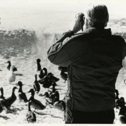
Alfred Etter observing ducks & geese on Arbor Lake in winter (3.4913)
Type: Photographic image
Description:Alfred Etter observing ducks & geese on Arbor Lake in winter
Extent: 1 photograph
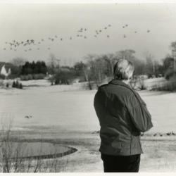
Alfred Etter observing ducks & geese in flight over Arbor Lake in winter (3.4911)
Type: Photographic image
Description:Alfred Etter observing ducks & geese in flight over Arbor Lake in winter
Extent: 1 photograph
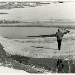
Alfred Etter observing ducks & geese on Arbor Lake in winter (3.4910)
Type: Photographic image
Description:Alfred Etter observing ducks & geese on Arbor Lake in winter
Extent: 1 photograph
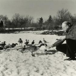
Alfred Etter feeding geese on frozen Arbor Lake (3.4901)
Type: Photographic image
Description:Alfred Etter feeding geese on frozen Arbor Lake
Extent: 1 photograph
Concept Park Boulevard Entrance (3.47501)
Date: January 9 2001Creator: Christopher B. Burke, Engineering West, Ltd.
Type: Map
Description:Color aerial map showing existing entrance and exit to be removed and proposed entrance, exit, and parking facility in 2001.
"Project No. 00-910"
Extent: 1 Sheet
The Morton Arboretum Inventory & Collections & Cultural Names (3.44609)
Date: April 25 1990Creator: Sidwell Company
Type: Map
Description:Four topographical maps with drawn area boundaries and area names written in marker. Page 5 is missing.
Extent: 4 Sheets
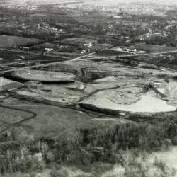
Arbor Lake construction, aerial view (3.44605)
Date: circa 1957Type: Photographic image
Description:Arbor Lake construction, aerial view
Extent: 1 filmstrip
Arbor Lake construction, aerial view (3.44604)
Date: circa 1957Type: Photographic image
Description:Arbor Lake construction, aerial view
Extent: 1 filmstrip
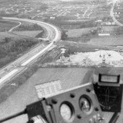
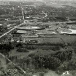
East/West Tollway and Arbor Lake construction, aerial view (3.44603)
Date: circa 1957Type: Photographic image
Description:East/West Tollway and Arbor Lake construction, aerial view
Extent: 1 filmstrip
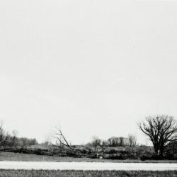
Bare trees, some fallen, near road (3.44600)
Date: circa 1957Type: Photographic image
Description:Bare trees, some fallen, near road, depicting land at or near location of Arbor Lake excavation
Extent: 1 filmstrip
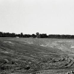
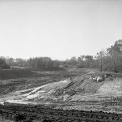
Arbor Lake construction, beginning of excavation (3.44599)
Date: circa 1957Type: Photographic image
Description:Arbor Lake construction, beginning of excavation
Extent: 1 filmstrip
Arbor Lake construction, beginning of excavation (3.44598)
Date: circa 1957Type: Photographic image
Description:Arbor Lake construction, beginning of excavation
Extent: 1 filmstrip
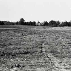
Empty field with line of trees in the distance (3.44597)
Date: circa 1957Type: Photographic image
Description:Empty field with line of trees in the distance, depicting land at or near location of Arbor Lake excavation
Extent: 1 filmstrip
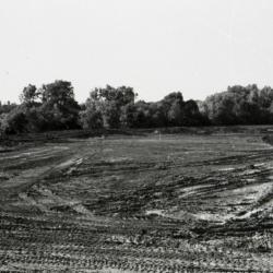
Arbor Lake under construction (3.44596)
Date: circa 1957Type: Photographic image
Description:Arbor Lake under construction
Extent: 1 filmstrip
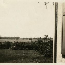
Clarence Godshalk's garden at first Arboretum house, field beyond now Arbordale and Arbor Lake (3.38219)
Date: 1920sType: Photographic image
Description:Clarence Godshalk's garden at first Arboretum house, field beyond now Arbordale and Arbor Lake
Extent: 1 photograph
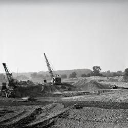
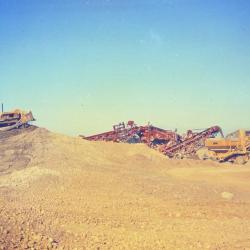
Arbor Lake excavation, men and equipment at work (3.37585)
Date: October 1957Creator: Gall, Richard
Type: Photographic image
Description:Arbor Lake excavation, men and equipment at work
Extent: 1 negative
Arbor Lake excavation (3.37584)
Date: October 1957Creator: Gall, Richard
Type: Photographic image
Description:Arbor Lake excavation
Extent: 1 negative
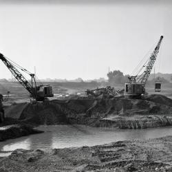
Arbor Lake excavation looking southwest (3.37583)
Date: October 1957Creator: Gall, Richard
Type: Photographic image
Description:Arbor Lake excavation looking southwest
Extent: 1 negative
Arbor Lake excavation, men and equipment at work (3.37478)
Date: 1957Type: Photographic image
Description:Arbor Lake excavation, men and equipment at work
Extent: 1 negative
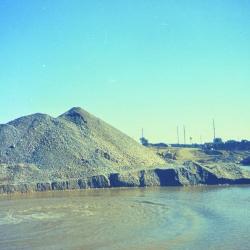
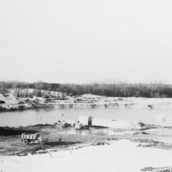
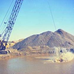
Arbor Lake excavation, mounds of dirt to the left of partially filled lake (3.37477)
Date: 1957Type: Photographic image
Description:Arbor Lake excavation, mounds of dirt to the left of partially filled lake
Extent: 1 negative
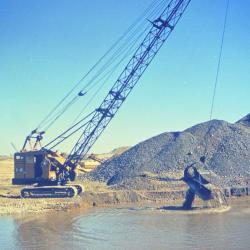
Arbor Lake excavation, man operating equipment in partially filled lake (3.37476)
Date: 1957Type: Photographic image
Description:Arbor Lake excavation, man operating equipment in partially filled lake
Extent: 1 negative
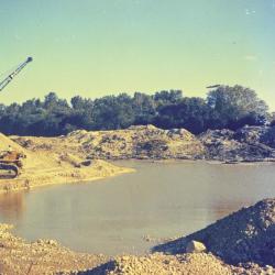
Arbor Lake excavation, man operating equipment to the left of partially filled lake (3.37475)
Date: 1957Type: Photographic image
Description:Arbor Lake excavation, man operating equipment to the left of partially filled lake
Extent: 1 negative
Arbor Lake excavation, man operating equipment in partially filled lake (3.37474)
Date: 1957Type: Photographic image
Description:Arbor Lake excavation, man operating equipment in partially filled lake
Extent: 1 negative