Browsing by object type: decade:
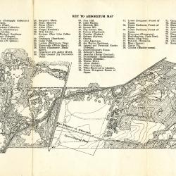
Data Concerning The Morton Arboretum and Map (3.106097)
Date: May 17 1930Type: Map
Description:Issue of the Bulletin of Popular Information with data concerning The Morton Arboretum and guide map.
Guide map details Arboretum roads, plant collections, buildings and points of interest. Collections are numbered and identified by a key at the top of the map.
The reverse side features information about the Arboretum including founding date, location, general organization of collections, the Bulletin of Popular Information, and how to reach the Arboretum.
Extent: 1 sheet
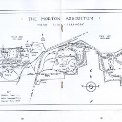
The Morton Arboretum Near Lisle, Illinois (3.106098)
Date: September 27 1934Creator: Kammerer, E. Lowell
Type: Map
Description:Guide map to The Morton Arboretum that is included in an issue of the Bulletin of Popular Information (Vol. 9, No. 9). Guide map details Arboretum roads, plant collections, buildings and points of interest. Key indicates proposed roads, native woodland, and forestry plots.
The remaining pages of the booklet include a biography of Joy Morton, a description of the Arboretum, a map showing how to reach the Arboretum, and a list of the Board of Trustees and lead staff members.
Extent: 14 pages
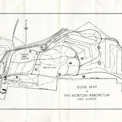
Guide Map of The Morton Arboretum (3.106099)
Date: 1936Type: Map
Description:Double-sided brochure with general information and a guide map of The Morton Arboretum.
Guide map details Arboretum roads, trails, parking, plant collections, buildings and points of interest. Sixteen areas on the grounds highlighted in the key and identified with numbers on the map.
Reverse side provides facts about the Arboretum, rules and regulations, and a list of the Board of Trustees and lead staff members.
Extent: 1 sheet
Plat of Dedication for Public Highway, Sections 33 & 34, T.39N. & Section 3, T.38N., R.10E. of the 3rd P.M., S.B. 1 Route 53, const. sec.534-X, DuPage County. (3.5299)
Date: November 1 1934Creator: Illinois Division of Highways
Type: Map
Description:"Tract 1, Joy Morton; Area: 1.136 acres." The survey identified the Route 53 right-of-way on the eastern roadside within the Arboretum.
Collection has additional plats on mylar detailing the subsections of the overall right-of-way.
70 (3.5300) and 71 (3.5301)
Extent: 1 sheet
Plat of Dedication for Public Highway, Section 34, T39N., R10E., Section 3, T 38N., R10E. of the 3rd P.M., S.B. 1. Route 53, const. sec.534-X, DuPage County (3.5300)
Date: December 21 1934Creator: Illinois Division of Highways
Type: Map
Description:Additional plat on mylar detailing the subsections of the overall right -of-way: 0.815 acres
Extent: 1 sheet
Plat of Dedication for Public Highway, Section 3, T 38N., R10E. of the 3rd P.M., S.B. 1. Route 53, const. sec.534-X, DuPage County (3.5301)
Date: December 21 1934Creator: Illinois Division of Highways
Type: Map
Description:Additional plat on mylar detailing the subsections of the overall right -of-way: 0.321 acres
Extent: 1 sheet
The Morton Arboretum and Joy Morton properties in DuPage County (3.5302)
Date: May 1934Creator: Kammerer, E. Lowell
Type: Map
Description:Shows lands within the Arboretum boundaries, giving original ownership, acreages, roadways, and some data on woodland cover; as well as Morton properties outside of northern Arboretum boundaries.
Extent: 1 sheet
The Morton Arboretum and Joy Morton Properties in DuPage County (3.5303)
Date: May 1934Creator: Kammerer, E. Lowell
Type: Map
Description:Shows lands within the Arboretum boundaries, giving original ownership, acreages, roadways, and some data on woodland cover; as well as Morton properties outside of northern Arboretum boundaries.
Extent: 1 sheet
The Morton Arboretum and Joy Morton Properties in DuPage County (3.5304)
Date: May 1934Creator: Kammerer, E. Lowell
Type: Map
Description:Shows lands within the Arboretum boundaries, giving original ownership, acreages, roadways, and some data on woodland cover; as well as Morton properties outside of northern Arboretum boundaries. Includes handwritten notes in pencil.
"Arboretum & Lisle Farms, Color coded; Late 40s" written in marker on back.
Extent: 1 sheet
Assessment Plat No. 1, Lands Belonging to Trustees Under the Will of Joy Morton, Deceased, Lisle, Township, DuPage County, Illinois (3.5305)
Date: September 29 1934Creator: Lozier, J. S.
Type: Map
Description:Surveys a "U"-shaped area, 94.056 acres, that spans Route 53 and extends northward from Warrenville Road into the South Farm area. The major interchange of the East-West Tollway and Route 53 is located within the present day tract.
Extent: 1 sheet
Assessment Plat No. 3, Lands Belonging to Trustees Under the Will of Joy Morton, Deceased, Milton and Lisle Townships, DuPage County, Illinois (3.5310)
Date: September 24 1934Creator: Lozier, J. S.
Type: Map
Description:Surveys approximately half of the East Woods area, a tract totaling 120.632 acres.
Includes unlabeled rough pencil drawings.
Extent: 1 sheet
Assessment Plat No.4, Lands Belonging to Trustees Under the Will of Joy Morton, Deceased, Milton Township, DuPage County, Illinois (3.5313)
Date: October 1 1934Creator: Lozier, J. S.
Type: Map
Description:Surveys a tract of 41.471 acres along the north boundary of the Arboretum.
Two areas highlighted in red pencil.
Extent: 1 sheet
Assessment Plat No.4, Lands Belonging to Trustees Under the Will of Joy Morton, Deceased, Milton Township, DuPage County, Illinois (3.5314)
Date: October 1 1934Creator: Lozier, J. S.
Type: Map
Description:Surveys a tract of 41.471 acres along the north boundary of the Arboretum.
Includes pencil outlines and notes.
"Plot showing land sold to Scott" written in pencil on the back of the survey.
Extent: 1 sheet
Assessment Plat No.4, Lands Belonging to Trustees Under the Will of Joy Morton, Deceased, Milton Township, DuPage County, Illinois (3.5316)
Date: October 1 1934Creator: Lozier, J. S.
Type: Map
Description:Surveys a tract of 41.471 acres along the north boundary of the Arboretum.
Extent: 1 sheet
Assessment Plat No.5, Lands Belonging to Trustees Under the Will of Joy Morton, Deceased, Milton Township, DuPage County, Illinois (3.5319)
Date: October 1 1934Creator: Lozier, J. S.
Type: Map
Description:Surveys a tract in the northern portion of the Arboretum, no longer within Arboretum boundaries.
Extent: 1 sheet
Revised Plat of Section "A," Morton Arboretum (3.5321)
Date: September 29 1934Creator: Lozier, J. S.
Type: Map
Description:Surveys the area west of Route 53 and south of Thornhill, a tract totaling 201.83 acres. The revised plat supersedes an earlier survey by Arthur L. Webster made in 1922 (SURV:B II (b) 1).
Extent: 1 sheet
Revised Plat of Section "B," Morton Arboretum (3.5325)
Date: November 21 1934Creator: Lozier, J. S.
Type: Map
Description:Surveys the area east of Route 53 in the central portion of the Arboretum and extending eastward to the East Woods, a tract totaling 318.996 acres.
Includes notes in red pencil.
Extent: 1 sheet
Revised Plat of Section "B," Morton Arboretum (3.5327)
Date: November 21 1934Creator: Lozier, J. S.
Type: Map
Description:Surveys the area east of Route 53 in the central portion of the Arboretum and extending eastward to the East Woods, a tract totaling 318.996 acres.
Extent: 1 sheet
Revised Plat of Section "C," Morton Arboretum (3.5330)
Date: December 11 1934Creator: Lozier, J. S.
Type: Map
Description:Surveys approximately half of the East Woods area, a tract totaling 158.117 acres.
Includes notes in red pencil.
Extent: 1 sheet
Revised Plat of Section "C," Morton Arboretum (3.5331)
Date: December 11 1934Creator: Lozier, J. S.
Type: Map
Description:Surveys approximately half of the East Woods area, a tract totaling 158.117 acres.
Extent: 1 sheet
Burial Plot Belonging to Sterling Morton, Jean Morton Cudahy, and Margaret Gray Morton; Part of the SE 1/4 of Section 34, Township 39N. Range 10E. of the Third Principal Meridian (3.5334)
Date: October 2 1934Creator: Lozier, J. S.
Type: Map
Description:Survey of a tract in the Thornhill area.
Includes measurements in pencil.
Extent: 1 sheet
Burial Plot Belonging to Sterling Morton, Jean Morton Cudahy, and Margaret Gray Morton; Part of the SE 1/4 of Section 34, Township 39N. Range 10E. of the Third Principal Meridian (3.5335)
Date: October 2 1934Creator: Lozier, J. S.
Type: Map
Description:Survey of a tract in the Thornhill area.
Extent: 1 sheet
Lands Belonging to Morton Arboretum Subject to Life Estate in Margaret Gray Morton, Sterling Morton, and Jean Morton Cudahy (3.5337)
Date: October 4 1934Creator: Lozier, J. S.
Type: Map
Description:Surveys the area immediately around the Joy Morton residence at Thornhill.
Extent: 1 sheet
Survey of Part of Sections 35 and 36, Township 39N. R.10E., and Part of Sections 1 and 2, Township 38N. R.10E. of the 3rd. Principal Meridian, DuPage County, Illinois (3.5340)
Date: July 24 1935Creator: Lozier, J. S.
Type: Map
Description:Survey shows a tract of 40.58 acres, a portion of the Thoman farm, located in the eastern portion of the Arboretum. See A.H. Nelson (SURV:B IV (a) 5) for the entire 119.76 acres of the Thoman Farm surveyed.
Extent: 1 sheet
Plat Showing the Thoman Farm in Sections 35 and 36, Township 39N. Range 10 East, and Sections 1 and 2, Township 38N. Range 10 East of the Third Principal Meridian in DuPage Co., Illinois (owned by Mr. Sterling Morton) (3.5343)
Date: 1930sCreator: Steinbrecher, Harold F.
Type: Map
Description:Composite survey copied by H.F.Steinbrecher from earlier plats: 1) northern part of the Thoman Farm by J.S. Lozier and H.F. Steinbrecher dated July 24, 1935 ( SURV:B IV (a) 1); and 2) total acreage (119.76 acres) by A.H. Nelson dated March 26, 1935 (SURV:B IV (a) 5).
Extent: 1 sheet
Survey of Part of Lot Two of Assessment Plat No. 3 [Puffer Marsh Area] (3.5345)
Date: December 7 1939Creator: Steinbrecher, Harold F.
Type: Map
Description:Note in marker on back: "Puffer Lake Bird Sanctuary 1939."
Includes an area outlined in red.
Extent: 1 sheet
Survey of Part of Sections Two and Three, Township 38 North, Range 10 East of the Third Principal Meridian, in DuPage County, Illinois (3.5346)
Date: April 27 1938Creator: Steinbrecher, Harold F.
Type: Map
Description:Survey shows 4 contiguous tracts of 8.00, 6.570, 6.255, and 9.248 acres, not within Arboretum boundaries, located south of Warrenville Road.
Extent: 1 sheet
Administration Group for The Morton Arboretum, Lisle, Illinois: Administration Building (3.5452)
Date: September 26 1934Creator: Holabird & Root
Type: Map
Description:Sheets are numbered 1-12, construction plans, and M1-M3, utility installation drawings.
Sheet 12 (71 cm x 45 cm) has date Oct. 29, 1934.
Extent: 15 sheets
Tiling Map of the South Field, Mark Morton's Burdale Farm (3.5586)
Date: 1930sCreator: Steinbrecher, Harold F.
Type: Map
Description:Area shown lies in the northwestern corner of the Arboretum.
Extent: 1 sheet
The Morton Arboretum and Joy Morton properties in DuPage County (3.5618)
Date: May 1934Creator: Kammerer, E. Lowell
Type: Map
Description:Shows lands within the Arboretum boundaries, giving original ownership, acreages, roadways, and some data on woodland cover: as well as Morton properties outside of northern Arboretum boundaries.
Extent: 1 negative
[Plan of Development for Morton Arboretum, Lisle, Illinois, with preliminary collections grid and Arboretum's location with reference to northeastern Illinois] (3.5776)
Date: circa 1935Type: Map
Description:One of 3 closely related maps, untitled and undated, developed during the mid-1930s.
This map may have been prepared for collateral use in the Arboretum's informal series titled: Map & Visitor Guide. It contains schematic depiction of major plant collections, roads, and trails. This map also uniquely shows the collections grid in a preliminary format. A small diagram is also included in the upper right corner showing the Arboretum's location with reference to northeastern Illinois.
"Cross section map whole Arboretum" written in pencil on back of map.
Extent: 1 sheet
[Plan of Development for Morton Arboretum, Lisle, Illinois, #16] (3.5777)
Date: circa 1935Type: Map
Description:One of three closely related maps, untitled and undated, developed during the mid-1930s.
This map shows the locations of major plant collections, boundaries, roads, and trails. Parcels of land within the Arboretum not yet acquired (at date of issuance) are outlined on the line drawing. Some landmarks on map are numbered 1-16, but no key is drawn alongside the map to identify the numbered areas.
"Planting map of Morton Arboretum #16" and "Original of Information Folder map" written on back of map.
Extent: 1 sheet
[Plan of Development for Morton Arboretum, Lisle, Illinois, some landmarks numbered 1-15] (3.5778)
Date: circa 1935Type: Map
Description:One of three closely related maps, untitled and undated, developed during the mid-1930s.
This map shows major plant collections, boundaries, roads, and trails in line drawing. Some landmarks on map are numbered 1-15, but no key is drawn alongside the map to identify the numbered areas.
"Plan of Arboretum" written in ink on back of map.
Extent: 1 sheet
Atlas of DuPage Co., Ill. showing ownership; acreage; roads; railroads; city limits; subdivided areas, sections; and quarter sections; golf clubs; forest preserves; and other features (3.5896)
Date: 1930Creator: Steinbrecher, Harold F.
Type: Map
Description:Each township is shown on 1 sheet, except Downers Grove which is depicted on 2 sheets.
Extent: 12 sheets in binder
Atlas of DuPage Co., Ill. showing ownership; acreage; roads; railroads; city limits; subdivided areas, sections; and quarter sections; golf clubs; forest preserves; and other features (3.5897)
Date: 1930Creator: Steinbrecher, Harold F.
Type: Map
Description:Each township is shown on 1 sheet, except Downers Grove which is depicted on 2 sheets.
Extent: 12 sheets unbound
Atlas of DuPage Co., Ill. showing ownership; acreage; roads; railroads; city limits; subdivided areas, sections; and quarter sections; golf clubs; forest preserves; and other features (3.5898)
Date: circa 1936Creator: Steinbrecher, Harold F.
Type: Map
Description:Updated copies of sheet 5, Milton Township, and sheet 9, Lisle Township.
Extent: 2 sheets