Browsing by object type: decade:
Stormwater Master Plan (3.100277)
Date: August 26 1999Creator: Christopher B. Burke Engineering, Ltd.
Type: Map
Description:Areas outlined or highlighted with color markers.
Extent: 1 sheet
[Soils Mapped on the Schulenberg Prairie of the Morton Arboretum] (3.106096)
Date: circa 1990Creator: Hootman, Rick, Allen, Kimberly
Type: Map
Description:Numbered sections refer to soil series. Appears to be an early draft
Extent: 1 sheet
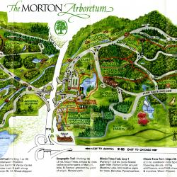
The Morton Arboretum Visitors Map and Guide (3.106100)
Date: 1994Creator: Halenza, D.
Type: Map
Description:Double-sided brochure, Visitors Map and Guide for The Morton Arboretum.
Map details Arboretum roads, trails, plant collections, buildings and boundaries.
Reverse side provides general information about the Arboretum, classes, Plant Clinic, the Sterling Morton Library, and the Visitor Center, which includes the Ginkgo Restaurant and Coffee Shop and Ginkgo Shop. Also includes a map showing how to reach the Arboretum.
Extent: 1 sheet
[Soil Map of the Schulenberg Prairie] (3.106151)
Date: circa 1990Type: Map
Description:Numbered sections refer to soil series on the Schulenberg Prairie. Appears to be an early draft
Extent: 1 sheet
Soil Map of The Morton Arboretum Prairie Restoration (3.106152)
Date: 1980 – circa 1990Type: Map
Description:Numbered sections refer to soil series on the Prairie Restoration at The Morton Arboretum, later named the Schulenberg Prairie. Key identifies number and name of soil series as well as the slope class.
Extent: 1 sheet
Schulenberg Prairie of The Morton Arboretum (3.106153)
Date: 1990Creator: Hootman, Rick
Type: Map
Description:Key indicates trails, perennial streams, and intermittent streams. Map also shows roads and surrounding buildings.
Extent: 1 sheet
Schulenberg Prairie of The Morton Arboretum (3.106154)
Date: 1990Creator: Hootman, Rick
Type: Map
Description:A map of the Schulenberg Prairie of The Morton Arboretum divided into 11 numbered sections. Key indicates trails, perennial streams, and intermittent streams. Map shows roads and surrounding buildings.
Extent: 1 sheet
Schulenberg Prairie of The Morton Arboretum (3.106155)
Date: 1990Creator: Hootman, Rick
Type: Map
Description:A map of the Schulenberg Prairie with the types of terrain labeled, such as upland savanna, lowland savanna, wet prairie, and hilltop prairie. Key indicates trails, perennial streams, and intermittent streams. Map also shows roads and surrounding buildings. A note reads, "Entrance to the Schulenberg Prairie is from Parking Lot 25 on the Arboretum's West Side. Follow the signs 'to the Prairie.'"
Extent: 1 sheet
[Aerial Photographs of The Morton Arboretum] (3.33779)
Date: November 29 1990Creator: Sidwell Company
Type: Map
Description:Aerial photograph taken Nov. 29, 1990 to be used in conjunction with the Sidwell Company's revised topographic map issued in 1990 ( SURV: A III (c) 2 1990 ). Collections grid crosses set out on Arboretum grounds are represented in the aerial survey by open triangles.
Extent: 5 sheets
Plat of Survey of Part of the Southeast 1/4 of Section 34 & the Southwest 1/4 of Section 35, Township 39 North, Range 10, East of the Third Principal Meridian, in DuPage County, Illinois. (3.33785)
Date: October 8 1992Creator: Roake & Associates, Inc.
Type: Map
Extent: 1 sheet
The Morton Arboretum (3.35349)
Date: 1990Creator: Sidwell Company
Type: Map
Description:The maps show images taken on December 16, 1985 and also April 25, 1990. The copyright date of the maps is 1990.
These maps are part of a 5 sheet set, but sheet 5 is missing.
Extent: 4 sheets
Plat of Survey Morton Arboretum Agreement Line (3.35378)
Date: February 11 1992Creator: Roake & Associates, Inc.
Type: Map
Extent: 1 sheet
The Morton Arboretum Grounds Map (3.36161)
Date: July 1998Creator: Hitchcock Design Group
Type: Map
Extent: 1 sheet
Woody Plant Collections: Historic Views (3.41528)
Date: April 1999Creator: Walker, Catherine
Type: Map
Description:Tracing over Arboretum brochure (Woody Plant Collections of The Morton Arboretum) with notations from Catherine Walker. Numbers relate to photograph booklet.
Extent: 1 sheet
Map of Natural Area Management Types (3.44607)
Date: March 26 1992Creator: Butkovich, Dianne
Type: Map
Description:Printed topographical map with hand-drawn lines and hand-numbered regions.
Attached Key includes notes on natural area types, restoration areas, and restoration techniques.
Extent: 1 Sheet
Lake Marmo Visitor Station Survey Worksheet (3.44608)
Date: May 5 1999Type: Map
Description:Topographic map of Lake Marmo and Visitor Station with elevation bench marks.
Extent: 1 Sheet
The Morton Arboretum Inventory & Collections & Cultural Names (3.44609)
Date: April 25 1990Creator: Sidwell Company
Type: Map
Description:Four topographical maps with drawn area boundaries and area names written in marker. Page 5 is missing.
Extent: 4 Sheets
Existing Noise Contouring Map (3.47257)
Date: April 1999Creator: HDR Engineering, Inc.
Type: Map
Description:Topographical map of the Arboretum grounds in 1999 with noise contour lines and measurements of sound in dB(A).
The Morton Arboretum [topographic map] [Revised] (3.5488)
Date: 1990Creator: Sidwell Company
Type: Map
Description:Topographic data produced from aerial photography orginally made Dec.16,1985 (SURV:A III (c) 2); updated for the revision on April 25,1990. True elevations given. Includes Hidden Lake leased land.
Extent: 5 sheets
Woody Plant Collections, The Morton Arboretum [Collections Grid, by Ronald M. Coulter and Nancy Hart Stieber, 1990, overlays for vegetation, trails, grid, and landmarks] (3.5824)
Date: 1990Creator: Coulter, Ronald M.
Type: Map
Description:An updated map used in the informational leaflet titled: Woody Plant Collections of The Morton Arboretum, Map & Guidelines for Locating Plants
This version is a set of four mylar overlays, separating vegetation, trails, grid layout, and landmarks/collections.
Extent: 4 sheets
Woody Plant Collections, The Morton Arboretum [Collections Grid, by Ronald M. Coulter and Nancy Hart Stieber, 1990, base map of roads and parking lots] (3.5825)
Date: 1990Creator: Coulter, Ronald M.
Type: Map
Description:An updated map used in the informational leaflet titled: Woody Plant Collections of The Morton Arboretum, Map & Guidelines for Locating Plants
This version only shows base map of roads and parking lots.
Extent: 1 sheet
Northwest force main improvement, Downers Grove Sanitary District, DuPage County (3.5832)
Date: February 1992Creator: Wight & Company
Type: Map
Description:Plans "released for bidding".
Extent: 10 sheets in binder
Recent and Proposed Conservation Projects of The Morton Arboretum (3.5891)
Date: January 1991Creator: Hootman, Rick
Type: Map
Description:Map developed for a grant proposal to the Institute of Museum Services (IMS).
Includes key for proposed project areas, recent projects identifies areas of open water and marsh.
Proposed Project Areas: 1)Fischer Research Tract 2) Pin Oak Collection 3) Planted Berms 4) Honey Locust, Green Ash, Tulip Tree, American Elm Collections
Recent Projects: Conservation Nursery (1984), Ecosystems Survey (1985), East Woods, Prairie, Soil Survey (1986)
Extent: 1 sheet
South Farm stormwater management facilities (3.5946)
Date: June 1990Creator: Sheaffer and Roland, Inc.
Type: Map
Description:Revision of plans developed in April 1990.
Extent: 5 sheets in binder
[Limits of glaciation in Illinois] (3.5977)
Date: October 1990Creator: Butkovich, Dianne
Type: Map
Description:Prepared for the Morton Arboretum Quarterly, Vol. 26, No. 3, Autumn 1990. Article entitled "Landscape Features of The Morton Arboretum" by Richard Hootman and Patrick Kelsey.
Extent: 1 sheet
[Elevation Bench Marks on the Arboretum] (3.6110)
Date: May 1 1992Creator: Hootman, Rick
Type: Map
Description:Base map is a 1990 aerial photo of the Morton Arboretum prepared by the Sidwell Company of West Chicago, IL. Includes an 8.5"x11" sheet providing exact benchmark locations and elevations.
Extent: 5 sheets in binder
Plat of Survey, Morton Arboretum [Hidden Lake] Agreement Line [with the Forest Preserve District of DuPage County] (3.6111)
Date: May 26 1992Creator: Roake & Associates, Inc.
Type: Map
Extent: 1 sheet
Plans for proposed Federal Aid Highway FAU Route 2578 (IL 53)… DuPage County (3.6116)
Date: October 25 1992Creator: Illinois Division of Highways
Type: Map
Extent: 69 sheets clipped together
The Morton Arboretum Site Plan (3.6171)
Date: March 1992Creator: R. H. Anderson & Associates, Inc.
Type: Map
Description:Original drawings dated 11/26/91. Updated revisions in March 1992.
Extent: 8 sheets
[Tax Parcel Maps in and Around The Morton Arboretum] (3.6173)
Date: 1992Creator: DuPage County
Type: Map
Description:Parcel numbers are included on the parcels.
Extent: 1 sheet
Northwest pumping station improvement, Downers Grove Sanitary District, DuPage County (3.6176)
Date: April 21 1993Creator: Wight & Company
Type: Map
Extent: 4 sheets in binder
Endangered Species Habitat (3.6177)
Date: March 26 1992Creator: Tyznik, Anthony
Type: Map
Description:Layout of habitat with elevations
Extent: 1 sheet
Irrigation System, Thornhill Forecourt Development (3.6204)
Date: March 22 1995Creator: Halloran & Yauch, Inc.
Type: Map
Description:Instructions on draining the irrigation system for winter.
Extent: 1 sheet
Watershed Delineation Maps (3.6210)
Date: 1991Creator: Hootman, Rick
Type: Map
Description:Watersheds superimposed on topographic maps produced by the Sidwell Company.
Extent: 5 sheets
Gas light layout from Parking 1 to Administration and Research Center (3.6211)
Date: September 25 1995Creator: Mehaffey, Scott A.
Type: Map
Description:33 path lights for 1995, 16 parking lot lights for 1996
Extent: 1 sheet
Map Shelter [& details] (3.6212)
Date: August 31 1995Creator: Sullivan, Andrew J.
Type: Map
Description:Sheets are numbered 1 of 2, 2 of 2. Sheet 1 of 2, elevation-front and side view (1" = 1 '-0"). Sheet 2 of 2, rafter plan (1" = 1 '-0"), floor plan 1" = 1 '-0"), bench support (1/4" = 1 "), wooden peg detail (1/2" = 1 ").
Extent: 2 sheets