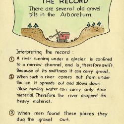
Arboretum Landscape Teaching Aid Series: A River Emerged From Under A Glacier (3.19497)
Date: 1940 – 1960Creator: Watts, May Theilgaard
Type: Drawing
Description:Primarily textual teaching aid depicting Arboretum landscape. This material shows the origin of gravel pits at the Arboretum.
Header: A RIVER EMERGED FROM UNDER A GLACIER
Text and illustrations from top to bottom:
- [Depicted in stylized scroll with illustration of a steam shovel in gravel pit] The Record: There are several old gravel pits in the Arboretum.
- Interpreting the record:
- 1) A river running under a glacier is confined to a narrow channel, and is, therefore swift. Because of its swiftness it can carry gravel.
- 2) When such a river comes out from under the ice it spreads out and slows down. Slow moving water can carry only fine material. Therefore the river dropped its heavy material.
- 3) When men found these places they dug the gravel out.
Extent: 1 sheet

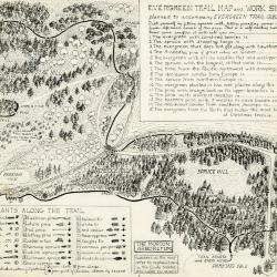
Forest Nature Trail Guide, page 9 illustrations and layout with preliminary sketches (3.24659)
Date: 1946Creator: Watts, May Theilgaard
Type: Drawing
Description:Sheet One: Original illustrations and layout for page 9, for The Morton Arboretum Forest Nature Trail Guide booklet. Key lines included.
Illustrated stumps with numbers indicate points of interest along trail as seen on trail map.
Tree stump #18: Garter snake
Includes an illustration of a coiled garter snake to the right.
Tree stump #19: Bracken fern
Identifying characteristics for leaves illustrated to the right.
Tree stump #20: Gravel pit
Three illustrations of a gravel pit labeled "1," "2," and "3" showing stages of vegetation regrowth over time.
Tree stump #21: Slime flux
Name of chronic bleeding from the side of an Elm tree. Identifying characteristics for Elm leaf illustrated to the right.
Sheet Two: Preliminary sketch of green-colored illustrations.
Extent: 2 sheets
Evergreen Nature Trail Guide: evergreen trail map and work sheet (3.24663)
Date: 1940sCreator: Watts, May Theilgaard
Type: Document
Description:Original illustrations and layout for the Evergreen Trail Map and Work Sheet planned to accompany The Morton Arboretum Evergreen Trail Guide booklet. Signed "by M. T. Watts" in bottom right corner.
Work sheet in top right corner included to test your conifer knowledge. Bottom left list of plants along the trail used in conjunction with worksheet in top right corner.
Illustrated map includes names of plants along the trail as well as numbers referring to explanations in the Guide booklet.
Extent: 1 sheet
Lake Marmo Cleaning: truck dumping sediment in gravel pit (3.31752)
Date: 1939Type: Photographic image
Description:Lake Marmo Cleaning: truck dumping sediment in gravel pit
Job done by Yackley of Lisle
Extent: 1 negative

Lake Marmo Cleaning: truck dumping sediment from Lake Marmo in gravel pit, two men overseeing (3.32245)
Date: 1939Type: Photographic image
Description:Lake Marmo Cleaning: truck dumping sediment from Lake Marmo in gravel pit, two men overseeing
Job done by Yackley of Lisle
Extent: 1 negative

View east from Meadow Road near Puffer gravel pit (3.32771)
Date: 1930Type: Photographic image
Description:View east from Meadow Road near Puffer gravel pit
Extent: 1 negative
Unpaved road through wooded area near Puffer gravel pit (3.32772)
Date: 1930Type: Photographic image
Description:Unpaved road through wooded area near Puffer gravel pit
Extent: 1 negative
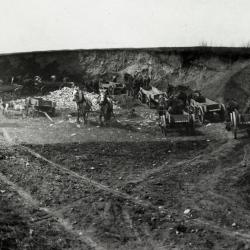
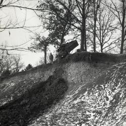
Gravel pit with wagons and horses on top of Yackley Hill along Butterfield Road (3.33507)
Date: 1916Type: Photographic image
Description:Gravel pit with wagons and horses on top of Yackley Hill along Butterfield Road
Unusual dump wagons - note boards sticking out in rear. First the wagon side was lifted off, then each board was turned and gravel would dump out. After 1921, dump wagons with hinged bottoms were used.
Extent: 1 negative filmstrip
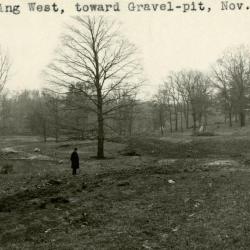
Joy Morton near sugar maple at west end of Lake Marmo site (3.3463)
Date: November 26 1921Type: Photographic image
Description:Looking west, toward gravel pit
Joy Morton near sugar maple at west end of Lake Marmo site
Pine Hill now on hill to right of maple
Extent: 1 photograph

Hemlock Hill overlooking gravel pit (3.37876)
Type: Photographic image
Description:Hemlock Hill overlooking gravel pit
Extent: 1 negative
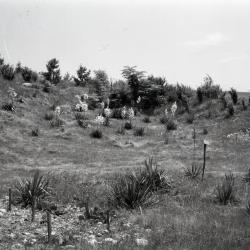
Gravel pit plantings east of Meadow Lake (3.38258)
Date: 1930 – 1949Type: Photographic image
Description:Gravel pit plantings east of Meadow Lake
Extent: 1 negative
Plat of Survey of Part of Sections Twenty-five (25) and Twenty-six (26), Township Thirty-nine (39) North, Range Ten (10) East of the Third Principal Meridian in DuPage County, Illinois (3.6069)
Date: August 14 1963Creator: Steinbrecher, Harold F.
Type: Map
Description:Land surveyed includes a gravel pit and easement, presumably owned by Mortons at one time. Original survey done Nov. 14, 1958. Adjacent to SURV:B V (a) 4.
Extent: 1 sheet
Topographical Map of Gravel Pit on the Thoman Farm - Estate of Joy Morton near Glen Ellyn Illinois (3.6781)
Date: October 10 – November 20 1940Creator: Steinbrecher, Harold F.
Type: Map
Extent: 1 sheet
Topographical Map of Gravel Pit on the Thoman Farm - Estate of Joy Morton near Glen Ellyn Illinois [with markings]] (3.6783)
Date: October 10 – November 20 1940Creator: Steinbrecher, Harold F.
Type: Map
Description:This copy includes red pencil outline labeled "Bank on Nov. 20, 1940" and notes "Red shows levels on Nov. 20, 1940" and "3918 cu. yds. removed from Oct. 10 to Nov. 20"
Extent: 1 sheet