[Topographic maps of the United States] Illinois topography… mapped, edited, and published by the Geological Survey in cooperation with State of Illinois Geological Survey (3.6552)
Date: 1922 – 1954Creator: Geological Survey (U.S.)
Type: Map
Description:Sheets 2-6 are same as REF:B I (a) 1 - REF:B II (b) 1. Sheet 1 - Belvedere Quadrangle - Illinois - Wisconsin. Sheet 2 - Herscher Quadrangle. Sheet 3 - Kankakee Quadrangle. Sheet 4 - Momence Quadrangle - Illinois - Indiana. Sheet 5 - Wilmington Quadrangle. Sheet 6 - Yorkville Quadrangle.
Extent: 6 sheets
[Tollway Right-of-way and Easements Over the Southern Portion of the Thoman Farm] (3.5371)
Date: 1950sType: Map
Description:Acreages decicated to right -of-way are shown by colored shading. These data are shown on the composite survey copied by H.F. Steinbrecher from earlier plats titled: Plat showing the Thoman Farm, and issued ca. 1935.
Extent: 1 sheet
[Tollway Right-of-way and Easements in] Assessment Plat No. 2 (3.5370)
Date: 1950sType: Map
Description:Acreages dedicated to right-of-way are shown by colored shading. These data are shown on the plat made by J.S. Lozier and H.F. Steinbrecher titled: Assessment Plat No.2, and issued Oct.1, 1934.
Extent: 1 sheet
[Tollway Right-of-way and Easements Along Route 53 in] Assessment Plat No. 1 (3.5369)
Date: 1950sType: Map
Description:Acreages dedicated to right-of-way are shown by colored shading. These data are shown on the plat made by J.S. Lozier and H.F. Steinbrecher titled: Assessment Plat No. 1, and issued Sept.29, 1934.
Extent: 1 sheet
[Tollway Right-of-way and Easements Along Finley Road in] Assessment Plat No. 3 (3.5372)
Date: 1950sType: Map
Description:Acreages dedicated to right-of-way are shown by colored shading. These data are shown on the plat made by J.S. Lozier and H.F. Steinbrecher titled: Assessment plat no. 3, and issued Sept. 24, 1934.
Extent: 1 sheet
[Thornhill House] Details of New Metal Windows on South Elevation of Lecture Hall (3.5550)
Date: August 18 1954Creator: Holabird & Root
Type: Plan
Description:Sheet numbered A-1 (Note: Stapled with Morton memorial panels, see STRU: F II (b) 4a( Accession number 1031))
Extent: 1 sheet
[Thorndale Apartments] (3.5492)
Date: 1950sCreator: Godshalk, Clarence E.
Type: Plan
Description:Ms. note on verso: "Thorndale Apt. plans by CEG: D-4, 3S480 Park Blvd."
Structure located near Thornhill Education Center. Notes in ink added.
Extent: 3 sheets stapled
[Planting plans for Courtland Street and Palmer Street [cartographic material] / O.C. Simonds]. (3.24871)
Date: 20th centuryCreator: Simonds, O. C.
Type: Plan
Extent: 1 plan 98 x 37 cm.
[Picnic Shelter] Plan, End and Front Elevations (3.6336)
Date: 1954Creator: Tyznik, Anthony
Type: Plan
Description:Located north of Park Blvd. and west of Rte. 53.
Front and end elevations.
Extent: 1 sheet
[Greenhouse plans for Morton Arboretum, Lisle, IL] (3.6510)
Date: December 14 1954 – April 22 1955Creator: Lord & Burnham Company
Type: Plan
Description:Plans contain drawings 1-16, 6D, 11A, 16AD, V1-3, H4 of various plans, elevations, cross-sections and details
Extent: 23 sheets
Young ferns [graphic] / Clare Leighton. (3.26525)
Date: 20th centuryCreator: Leighton, Clare, 1898-1989.
Type: Print
Extent: 1 print : wood engraving, b&w 17 x 13 cm.
Wood duck / F.L. Jaques. (3.30416)
Date: 1950sCreator: Jaques, Francis Lee, 1887-1969.
Type: Painting
Extent: 1 print : photomechanical reproduction image 23 x 17 cm., on sheet 28 x 22 cm.
Wisteria scroll (3.31487)
Date: 20th centuryType: Painting
Extent: 1 scroll : brush and ink, watercolor ; 27 x 145 cm.
Wisteria and euonymus scroll (3.31485)
Date: 20th centuryType: Painting
Extent: 1 scroll : brush and ink, watercolor ; 28 x 45 cm.
Willow branches [graphic]. (3.24543)
Date: 20th centuryCreator: Hassall, Joan.
Type: Drawing
Extent: 1 drawing : brush and pen, one color 25 x 21 cm.
White double peony and monarch butterfly (3.31483)
Date: 20th centuryType: Painting
Extent: 1 painting : gouache, color 18 x 11 cm.
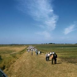
Wheatland Plowing Match, spectators viewing a plowing contest (3.36249)
Date: 1950sType: Photographic image
Description:Groups of spectators are gathered in a field that is being plowed for the Wheatland Plowing Match in Wheatland Township, Illinois. A yellow sign to the left reads: NO CARS / [o]n / CONTEST / FIELD
This image is part of a group of slides that belonged to May T. Watts, related to her book Reading the Landscape.
Extent: 1 slide
Wheatland Plowing Match, spectators viewing a newly plowed field (3.36246)
Date: 1950sType: Photographic image
Description:Groups of spectators view a newly plowed field created during the Wheatland Plowing Match in Wheatland Township, Illinois. A barbed wire fence and prairie grasses appear in the foreground.
This image is part of a group of slides that belonged to May T. Watts, related to her book Reading the Landscape.
Extent: 1 slide

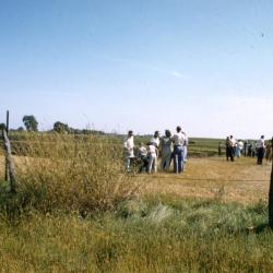
Wheatland Plowing Match, spectators observing furrows (3.36244)
Date: 1950sType: Photographic image
Description:Spectators observe a newly plowed field created during the Wheatland Plowing Match in Wheatland Township, Illinois. A barbed wire fence and prairie grasses appear in the foreground.
This image is part of a group of slides that belonged to May T. Watts, related to her book Reading the Landscape.
Extent: 1 slide
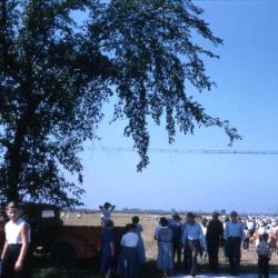
Wheatland Plowing Match, spectators near a large tree (3.36251)
Date: 1950sType: Photographic image
Description:Spectators walk past a large tree at the Wheatland Plowing Match in Wheatland Township, Illinois.
This image is part of a group of slides that belonged to May T. Watts, related to her book Reading the Landscape.
Extent: 1 slide

Wheatland Plowing Match, pony rides (3.36250)
Date: 1950sType: Photographic image
Description:Children enjoy pony rides at the Wheatland Plowing Match in Wheatland Township, Illinois. Several vehicles are parked to the right of the activity.
This image is part of a group of slides that belonged to May T. Watts, related to her book Reading the Landscape.
Extent: 1 slide

Wheatland Plowing Match, contestant plowing furrows (3.36259)
Date: 1950sType: Photographic image
Description:A participant in the Wheatland Plowing Match plows furrows in a field in Wheatland Township, Illinois. Other particpants and spectators are visible in the background.
This image is part of a group of slides that belonged to May T. Watts, related to her book Reading the Landscape.
Extent: 1 slide
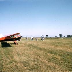
Wheatland Plowing Match, airplanes in a field (3.36247)
Date: 1950sType: Photographic image
Description:A red airplane sits in a field, while spectators walk past during the Wheatland Plowing Match in Wheatland Township, Illinois. Another plane is visible behind the first plane.
This image is part of a group of slides that belonged to May T. Watts, related to her book Reading the Landscape.
Extent: 1 slide

Wheatland Plowing Match, a newly plowed field (3.36245)
Date: 1950sType: Photographic image
Description:A newly plowed field created during the Wheatland Plowing Match in Wheatland Township, Illinois. A barbed wire fence and prairie grasses appear in the foreground.
This image is part of a group of slides that belonged to May T. Watts, related to her book Reading the Landscape.
Extent: 1 slide
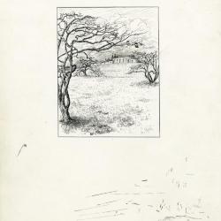
View of Thornhill (3.31060)
Date: 20th centuryCreator: Watts, May Theilgaard
Type: Drawing
Description:Illustration of view up the hill to the Thornhill Education Center at The Morton Arboretum, with bare trees and mushrooms in foreground, clouds and trees behind building in background, and an ink border.
Illustration used as image for printed notecards.
Extent: 1 sheet

Vernal Witch-hazel (3.19477)
Date: 1940 – 1960Creator: Watts, May Theilgaard
Type: Drawing
Description:Illustration of the Vernal witch-hazel plant, including three detailed views and some descriptive text. Background sketches include trees at top and center, and shrubs at center and bottom.
Header: VERNAL WITCH-HAZEL, HAMAMELIS vernalis
Illustrations as depicted, from top to bottom, left to right:
- a single pistil, labeled PISTIL
- two stamens, front view and side view, labeled STAMEN
- a single twig in bloom
- a flower
Extent: 1 sheet
Union Park, [Chicago [cartographic material] : planting plan] / Jens Jensen. (3.24899)
Date: 20th centuryCreator: Jensen, Jens
Type: Plan
Extent: 1 plan 51 x 55 cm.

Under the Roost of the Long-Eared Owls (3.24641)
Date: 20th centuryCreator: Watts, May Theilgaard
Type: Drawing
Description:Four illustrations depicting long-eared owls and their pellets. Captions accompany each individual illustration. The drawings illustrate the story OWL PELLETS GALORE by May Theilgaard Watts, Naturalist at The Morton Arboretum.
Upper left text: UNDER the ROOST of the LONG-EARED OWLS
Illustrations with captions, from left to right, top to bottom:
- Drawing of an owl pellet
- Caption: An owl pellet
- Drawing of forest floor, including rhododendron
- Caption: When rhododendron leaves uncurl we find pellets.
- Drawing of rodent bone findings
- Caption: Each pellet reveals parts of a small rodent.
- Drawing of two owls in a tree
- Caption: They seem to grow taller as we approach.
Extent: 1 sheet
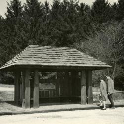
Two people approaching Arboretum Map Station (3.3572)
Date: 1950sType: Photographic image
Description:Two people approaching Arboretum Map Station
Extent: 1 photograph

Transcript of presentation written for the Illinois Nurserymen's Association (3.64475)
Date: 1920 – 1959Creator: Teuscher, Henry
Type: Document
Description:Talk given to the Illinois Nurserymen's Association describing the Morton Arboretum and it's mission. It stresses the importance of shared information and how the Arboretum is not in competition with the nurseries in the area.
Topographical Map of a Portion of Assessment Plat No. 4, Lands Belonging to Trustees Under the Will of Joy Morton, Deceased, near Lisle, DuPage County, Illinois (3.5255)
Date: January 15 1954Creator: Steinbrecher, Harold F.
Type: Map
Description:Shows designs for a subdivision that was never developed in the Park Blvd. and Main Thornhill Drive area. Elevations are based on an arbitrary benchmark. "Topo of Land South of S(t)romquist, N. of Main Drive, W. Side" in pencil on reverse of map.
Extent: 1 sheet
Topographical Map of a Portion of Assessment Plat No. 1, Lands Belonging to Trustees Under the Will of Joy Morton, Deceased, near Lisle, DuPage County, Illinois (3.5257)
Date: January 30 1954Creator: Steinbrecher, Harold F.
Type: Map
Description:Surveys area in which the Arbordale subdivision now is located. Elevations are based on an arbitrary benchmark. "Topo of Housing Site S. of CEO Residence" is in pencil on the back of the map.
Extent: 1 sheet
Tilia americana wreath [graphic] / N.S. Hart. (3.24351)
Date: 20th centuryCreator: Hart, Nancy
Type: Drawing
Extent: 1 drawing : pen and ink, b&w image 32 x 25 cm., on board 35 x 28 cm.
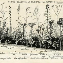
Three Seasons of Bloom in the Prairie (3.24642)
Date: 20th centuryCreator: Watts, May Theilgaard
Type: Drawing
Description:Illustration of 23 prairie plants shown in a chart formation categorized by Fall, Summer, and Spring from top to bottom, and from high prairie to low prairie from left to right. Identifying text appears beneath each illustration, some of which is on strip of board attached to the bottom with tape.
Header: THREE SEASONS of BLOOM in the PRAIRIE
Text, top right: the individual plants represent colonies of varying sizes
Plants as depicted from top to bottom, left to right:
- Fall
- big bluestem
- blazing star
- Indian grass
- wild rye
- switch grass
- saw-toothed sunflower
- prairie dock
- cord grass
- Summer
- lead plant
- New Jersey tea
- flowering spurge
- stiff goldenrod
- black-eyed Susan
- Culver's root
- tall meadow rue
- Sullivant's milkweed
- Spring:
- bird's-foot violet
- blue-eyed grass
- puccoon
- downy phlox
- wild strawberry
- Canada anemone
- yellow star grass
Extent: 1 sheet
Three calligraphic poems [graphic] / Masudo. (3.24561)
Date: 20th centuryCreator: Masudo.
Type: Drawing
Extent: 4 drawings : calligraphy, b&w with red seals 27 x 25 cm.