[Aerial photographs of Morton Arboretum] (3.6624)
Creator: Sidwell Company
Type: Photographic image
Description:Sheets 1 and 2 include ink notes on tree locations.
From vault 2/99.
Extent: 4 sheets
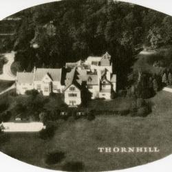
Morton Residence at Thornhill, aerial view (3.3455)
Type: Photographic image
Description:Morton Residence at Thornhill, aerial view
Extent: 1 photograph

Aerial view of Thornhill Residence looking north amid Parsons Grove on west side of DuPage River (3.3628)
Creator: Curtiss-Wright
Type: Photographic image
Description:Photograph taken during an aerial survey depicting Thornhill Residence looking north amid Parsons Grove on west side of DuPage River
Extent: 1 photograph
The Morton Arboretum Master Site Plan (3.39966)
Type: Plan
Description:Aerial view of The Morton Arboretum colored in color pencil.
[Retaining wall project] (3.31984)
Type: Plan
Description:Shows south edge of The Morton Arboretum along I-88 east of Route 53.
Extent: 1 sheet

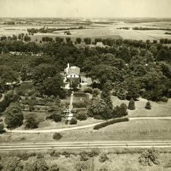
Aerial view of entire Morton Farm and estate (relay tower in distance) (3.3143)
Creator: Curtiss-Wright
Type: Photographic image
Description:Photograph taken during an aerial survey depicting entire Morton farm and estate (relay tower in distance)
Extent: 1 photograph
Aerial view of Administration Building, greenhouses, nursery, South Farm (3.38489)
Type: Photographic image
Description:Aerial view of Administration Building, greenhouses, nursery, South Farm
Extent: 1 filmstrip
Aerial view of Arbor Lodge (3.3290)
Date: 20th centuryCreator: Savage, John S.
Type: Photographic image
Description:Aerial view of Arbor Lodge
Extent: 1 photograph
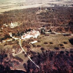
Aerial view of Morton residence at Thornhill and surrounding area, looking north (3.38604)
Date: 1930sType: Photographic image
Description:Aerial view of Morton residence at Thornhill and surrounding area, looking north
Extent: 1 negative
[Aerial Photograph of The Morton Arboretum] (3.5412)
Date: 1939Type: Photographic image
Description:The photos are individually identified as follows: BWS-1-72 through BWS-1-75 and BWS-3-11 through BWS-3-14. Each bears the date: 8-24-39; however, empty agricultural fields shown indicate that the exposures would have been made in the spring. The set was purchased in 1990 from the Agricultural Stabilization and Conservation Service (ASCS).
Extent: 8 sheets in envelope
[Aerial Photograph of the Morton Arboretum] (3.6051)
Date: circa 1940Creator: Chicago Aerial Survey Co.
Type: Photographic image
Description:Photomosaic print mounted on masonite board.
Areas outlined in red.
Collection has reduction mounted on masonite (1 inch = 900 feet, 70 cm x 29 cm)
Extent: 1 sheet mounted
[Aerial photograph of the Morton Arboretum] (3.5413)
Date: circa 1940Creator: Chicago Aerial Survey Co.
Type: Photographic image
Description:Photomosaic print mounted on masonite board.
Extent: 1 sheet
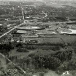
Arbor Lake construction, aerial view (3.44604)
Date: circa 1957Type: Photographic image
Description:Arbor Lake construction, aerial view
Extent: 1 filmstrip
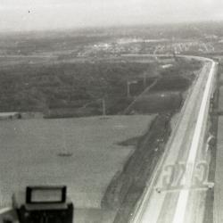
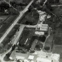
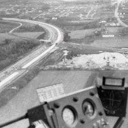
East/West Tollway construction near The Morton Arboretum, aerial view (3.44601)
Date: circa 1957Type: Photographic image
Description:East/West Tollway construction near The Morton Arboretum, aerial view
Extent: 1 filmstrip
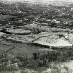
Arbor Lake construction, aerial view (3.44605)
Date: circa 1957Type: Photographic image
Description:Arbor Lake construction, aerial view
Extent: 1 filmstrip
East/West Tollway construction near The Morton Arboretum, aerial view (3.44602)
Date: circa 1957Type: Photographic image
Description:East/West Tollway construction near The Morton Arboretum, aerial view
Extent: 1 filmstrip
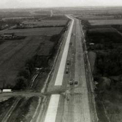
East/West Tollway and Arbor Lake construction, aerial view (3.44603)
Date: circa 1957Type: Photographic image
Description:East/West Tollway and Arbor Lake construction, aerial view
Extent: 1 filmstrip
[Oblique Aerial Photograph of The Morton Arboretum] (3.6009)
Date: circa 1958Creator: Metro News Photos
Type: Photographic image
Description:Copy 1 is a set of four photos (of various enlargements) set at oblique angles covering much of the Arboretum.
Extent: 4 photos
[Aerial Photograph of the Morton Arboretum and Adjacent Areas pt. 4] (3.5420)
Date: circa 1961Type: Photographic image
Description:The 4 survey photos, taken as stereographic pairs, are identified as follows and show the areas noted: [1] BWS-2BB-204, East half of the Arboretum and Glen Ellyn; [2] BWS-2BB-206, Northwest portion of the Arboretum and Wheaton/Glen Ellyn; [3] BWS-3BB-86, Southeastern portion of the Arboretum and Downers Grove; [4] BWS-3BB-88, Major southern portion of the Arboretum and Lisle.
Part 4
Extent: 1 sheet mounted on posterboard
[Aerial Photograph of the Morton Arboretum and Adjacent Areas pt. 1] (3.5417)
Date: circa 1961Type: Photographic image
Description:The 4 survey photos, taken as stereographic pairs, are identified as follows and show the areas noted: [1] BWS-2BB-204, East half of the Arboretum and Glen Ellyn; [2] BWS-2BB-206, Northwest portion of the Arboretum and Wheaton/Glen Ellyn; [3] BWS-3BB-86, Southeastern portion of the Arboretum and Downers Grove; [4] BWS-3BB-88, Major Southern portion of the Arboretum and Lisle.
Part 1
Extent: 1 sheet mounted on posterboard
[Aerial Photograph of the Morton Arboretum and Adjacent Areas pt. 2] (3.5418)
Date: circa 1961Type: Photographic image
Description:The 4 survey photos, taken as stereographic pairs, are identified as follows and show the areas noted: [1] BWS-2BB-204, East half of the Arboretum and Glen Ellyn; [2] BWS-2BB-206, Northwest portion of the Arboretum and Wheaton/Glen Ellyn; [3] BWS-3BB-86, Southeastern portion of the Arboretum and Downers Grove; [4] BWS-3BB-88, Major southern portion of the Arboretum and Lisle.
Part 2
Extent: 1 sheet mounted on posterboard
[Aerial Photograph of the Morton Arboretum and Adjacent Areas pt. 3] (3.5419)
Date: circa 1961Type: Photographic image
Description:The 4 survey photos, taken as stereographic pairs, are identified as follows and show the areas noted: [1] BWS-2BB-204, East half of the Arboretum and Glen Ellyn; [2] BWS-2BB-206, Northwest portion of the Arboretum and Wheaton/Glen Ellyn; [3] BWS-3BB-86, Southeastern portion of the Arboretum and Downers Grove; [4] BWS-3BB-88, Major southern portion of the Arboretum and Lisle.
Part 3
Extent: 1 sheet mounted on posterboard
[Morton Arboretum and environs] (3.6320)
Date: November 29 1963Creator: Chicago Aerial Survey Co.
Type: Map
Extent: 1 sheet
Morton Arboretum [Aerial Photograph and] Conservation Plan Map, Kane-DuPage Soil Conservation District. (3.5416)
Date: June 1964Creator: U.S. Soil Conservation Service
Type: Map
Description:Photomosaic produced from aerial photographs believed to have been taken in the 1940s. "Photo nos. BWS-8N-11, 8N-12, 8N-13, 4N-63, 4N-64, 4N-65, 4N-66, &4N-67." The photograph has been marked in ink with water features and major highways.
Extent: 1 sheet
Soil and Capability Map (3.6773)
Date: June 1964Creator: U.S. Soil Conservation Service
Type: Map
Description:Kane-DuPage Soil Conservation District and Soil Conservation Service. Map shows Arboretum with soil capabilities drawn in.
Extent: 1 sheet on board
Soil and Woodland Suitability Map (3.6169)
Date: March 1965Creator: U.S. Soil Conservation Service
Type: Map
Description:Uses photo probably from mid 1950s
Extent: 1 sheet
[Aerial photographs of the AT&T property west of the Arboretum] (3.6178)
Date: July 26 1967Creator: Airpix
Type: Map
Description:Outlined areas approximate the location of the Bell Lab, AT&T site.
Extent: 2 photos in folder
[Aerial Photograph of The Morton Arboretum and Adjacent Areas] (3.6011)
Date: November 19 1967Creator: Chicago Aerial Survey Co.
Type: Photographic image
Description:The five photos in copy 1, taken as stereo pairs, are numbered 1, 2, 4, 5, and 6 and extend from east to west across the Arboretum. A portion of the collections grid is identified by white crosses on the photos.
Extent: 5 sheets