
Two young girls coloring on Coloring Mural during Arbor Week (3.55606)
Date: April 1994Creator: Nachel, Jim
Type: Photographic image
Description:Two young girls coloring on Coloring Mural during Arbor Week. Coloring mural designed by Anthony T. Byrne.
Extent: 1 slide
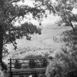
Looking south from Cedar Point over Iris test garden with wooden bench at edge of overlook in foreground (3.37820)
Date: 1930sType: Photographic image
Description:Looking south from Cedar Point over Iris test garden (now site of Arbor Vitae Collection, approx. P-22) with wooden bench at edge of overlook in foreground
The Morton Arboretum in conjunction with the American Iris Society maintained this iris test garden with over 900 different kinds of species.
Extent: 1 negative
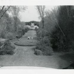
View of Four Columns and Arboretum visitors in Hedge Collection from atop Administration Building (3.36979)
Type: Photographic image
Description:View of Four Columns and Arboretum visitors in Hedge Collection from atop Administration Building
Extent: 1 photograph
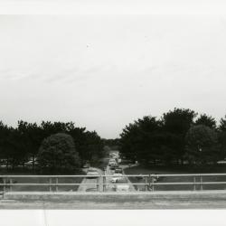
Sunday car traffic going under bridge (3.32055)
Date: 1960sType: Photographic image
Description:Sunday car traffic going under bridge
Extent: 1 photograph

Lake Marmo looking west toward islands (3.34023)
Date: 1920sType: Photographic image
Description:Lake Marmo looking west toward islands, wagon wheels in foreground on left
Extent: 1 negative
[Oblique aerial photograph of the Morton Arboretum] (3.6019)
Date: June 24 1982Type: Photographic image
Description:The pair of photos looks west at the Arboretum from Finley Road, and east from Route 53.
Extent: 2 sheets mounted
[Oblique aerial photograph of the Morton Arboretum] (3.6015)
Date: May 20 1969Creator: Airpix
Type: Photographic image
Description:The set of 4 oblique photos covers the eastern portion of the Arboretum at various angles.
Extent: 4 sheets
[Oblique Aerial Photograph of The Morton Arboretum] (3.6009)
Date: circa 1958Creator: Metro News Photos
Type: Photographic image
Description:Copy 1 is a set of four photos (of various enlargements) set at oblique angles covering much of the Arboretum.
Extent: 4 photos
[Oblique aerial photograph of the east half of the Morton Arboretum] (3.6018)
Date: January 8 1982Creator: Airpix
Type: Photographic image
Extent: 1 sheet mounted
[Oblique aerial photograph of the east half of the Morton Arboretum] (3.6017)
Date: January 12 1973Creator: Airpix
Type: Photographic image
Extent: 1 sheet
[Morton Arboretum color aerial photograph] (3.6862)
Date: October 1990Creator: Sidwell Company
Type: Photographic image
Description:Taken after completion of North-South Tollway. Stored on top of LAND/SURV cabinet.
Extent: 1 sheet
[Aerial photographs of the Morton Arboretum central area] (3.6355)
Date: April 3 1994Creator: DuPage County
Type: Photographic image
Description:Covers region from Thornhill on the NW; Eagle Lake on the NE; Crabapple Lake on the SE; Arbor Lake on the SW. For planning central area development for Master Plan.
Extent: 4 sheets
[Aerial photographs of Morton Arboretum] (3.6624)
Creator: Sidwell Company
Type: Photographic image
Description:Sheets 1 and 2 include ink notes on tree locations.
From vault 2/99.
Extent: 4 sheets
[Aerial photograph of] the Morton Arboretum [Willoway Creek] (3.5444)
Date: March 25 1986Creator: Sidwell Company
Type: Photographic image
Description:[Willoway Creek] 3 photographic negatives
Extent: 3 sheets
[Aerial photograph of] the Morton Arboretum [South Farm] (3.5443)
Date: March 25 1986Creator: Sidwell Company
Type: Photographic image
Description:[South Farm] 2 photographic negatives
Extent: 2 sheets
[Aerial photograph of] the Morton Arboretum [Crabapple Lake] (3.5441)
Date: March 25 1986Creator: Sidwell Company
Type: Photographic image
Description:[Crabapple Lake] photographic enlargement
Extent: 1 sheet
[Aerial photograph of] The Morton Arboretum (3.7126)
Date: April 1986Creator: Sidwell Company
Type: Photographic image
Extent: 6 sheets in binder
[Aerial photograph of] the Morton Arboretum (3.5438)
Date: March 25 1986Creator: Sidwell Company
Type: Photographic image
Description:Photographs taken from west to east; individual sheets overlap.
Extent: 5 sheets in binder
[Aerial Photograph of] Milton Township, DuPage Co. [Section 36] (3.5436)
Date: April 1981Creator: Northeast Illinois Planning Commission
Type: Photographic image
Description:Survey shows the northern portion of the Arboretum bordering on Wheaton and Glen Ellyn. One sheet is devoted to each of the Sections 33, 34, 35, and 36 of Milton Township in which Arboretum property is located.
This map is section 36.
Extent: 1 sheet
[Aerial Photograph of] Milton Township, DuPage Co. [Section 35] (3.5434)
Date: April 1981Creator: Northeast Illinois Planning Commission
Type: Photographic image
Description:Survey shows the northern portion of the Arboretum bordering on Wheaton and Glen Ellyn. One sheet is devoted to each of the Sections 33, 34, 35, and 36 of Milton Township in which Arboretum property is located.
This map is section 35.
Extent: 1 sheet
[Aerial Photograph of] Milton Township, DuPage Co. [Section 34] (3.5433)
Date: April 1981Creator: Northeast Illinois Planning Commission
Type: Photographic image
Description:Survey shows the northern portion of the Arboretum bordering on Wheaton and Glen Ellyn. One sheet is devoted to each of the Sections 33, 34, 35, and 36 of Milton Township in which Arboretum property is located.
This map is section 34.
Extent: 1 sheet
[Aerial Photograph of] Milton Township, DuPage Co. [Section 33] (3.5431)
Date: April 1981Creator: Northeast Illinois Planning Commission
Type: Photographic image
Description:Survey shows the northern portion of the Arboretum bordering on Wheaton and Glen Ellyn. One sheet is devoted to each of the Sections 33, 34, 35, and 36 of Milton Township in which Arboretum property is located.
This map shows section 33.
Extent: 1 sheet
[Aerial Photograph of] Lisle, Illinois Township, DuPage Co. (3.5430)
Date: April 1981Creator: Northeast Illinois Planning Commission
Type: Photographic image
Description:Survey shows the southern portion of the Arboretum bordering on Warrenville Road and the East-West Tollway. One sheet is devoted to each of the Sections 1, 2, and 3 of Lisle, Illinois Township in which Arboretum property is located.
This map shows section 3.
Written in marker on back of map: "2 sets 1:200 Phots Morton Arboretum 2-7-83."
Extent: 1 sheet
[Aerial Photograph of] Lisle, Illinois Township, DuPage Co. (3.5428)
Date: April 1981Creator: Northeast Illinois Planning Commission
Type: Photographic image
Description:Survey shows the southern portion of the Arboretum bordering on Warrenville Road and the East-West Tollway. One sheet is devoted to each of the Sections 1, 2, and 3 of Lisle, Illinois Township in which Arboretum property is located.
This map shows section 2.
Extent: 1 sheet
[Aerial Photograph of] Lisle, Illinois Township, DuPage Co. (3.5425)
Date: April 1981Creator: Northeast Illinois Planning Commission
Type: Photographic image
Description:Survey shows the southern portion of the Arboretum bordering on Warrenville Road and the East-West Tollway. One sheet is devoted to each of the Sections 1, 2, and 3 of Lisle, Illinois Township in which Arboretum property is located.
This map shows section 1.
Extent: 1 sheet
[Aerial photograph of the west half of the Morton Arboretum] (3.6016)
Date: October 17 1970Type: Photographic image
Description:The four photos, taken as stereo pairs, are numbered 3, 4, 5, and 6 and extend from Leask Lane to Route 53.
Extent: 4 sheets
[Aerial photograph of the Schulenberg Prairie] (3.92340)
Date: October 17 1970Type: Photographic image
Description:Two aerial images of the Schulenberg Prairie area. One photograph is black and white. One photograph is in color.
Extent: 2 sheets
[Aerial photograph of The Morton Arboretum] (3.91779)
Date: October 31 2001Creator: Sidwell Company
Type: Photographic image
Description:Print-out of color aerial photograph of The Morton Arboretum.
Extent: 1 sheet
[Aerial Photograph of the Morton Arboretum] (3.6051)
Date: circa 1940Creator: Chicago Aerial Survey Co.
Type: Photographic image
Description:Photomosaic print mounted on masonite board.
Areas outlined in red.
Collection has reduction mounted on masonite (1 inch = 900 feet, 70 cm x 29 cm)
Extent: 1 sheet mounted
[Aerial photograph of the Morton Arboretum] (3.5849)
Date: April 25 1990Creator: Sidwell Company
Type: Photographic image
Description:An initial set of photographs used by the Sidwell Company to develop its topographic map of the Arboretum, a revision that was issued in 1990 (SURV: A III (c) 2 1990) . " Project: T90-028." (See related objects link.) Collections grid is identified by white crosses set out on the Arboretum grounds.
Extent: 12 sheets in envelope
[Aerial Photograph of the Morton Arboretum] (3.5437)
Date: circa 1982Type: Photographic image
Description:Sheets are individually identified R-3639 EXP. 312A, B, C; 313A, B, C; 314 A, B, C; 315A, B, C, D; 316A, B; and 317A, B, C, D.
Extent: 19 sheets
[Aerial photograph of the Morton Arboretum] (3.5413)
Date: circa 1940Creator: Chicago Aerial Survey Co.
Type: Photographic image
Description:Photomosaic print mounted on masonite board.
Extent: 1 sheet
[Aerial Photograph of The Morton Arboretum] (3.5412)
Date: 1939Type: Photographic image
Description:The photos are individually identified as follows: BWS-1-72 through BWS-1-75 and BWS-3-11 through BWS-3-14. Each bears the date: 8-24-39; however, empty agricultural fields shown indicate that the exposures would have been made in the spring. The set was purchased in 1990 from the Agricultural Stabilization and Conservation Service (ASCS).
Extent: 8 sheets in envelope
[Aerial Photograph of the Morton Arboretum, sectional enlargements] (3.6562)
Date: circa 1977Type: Photographic image
Description:These photographs are a sectional enlargement of the Street Trees Collection appearing in the larger photograph, an area ca. one-quarter mile square located south of the King's Grove area. Copies 4, 5, 6 from vault 2/99.
Collections A
Extent: 3 sheets
[Aerial Photograph of the Morton Arboretum, sectional enlargements] (3.5423)
Date: circa 1977Type: Photographic image
Description:These photographs are a sectional enlargement of the Street Trees Collection appearing in the larger photograph, an area ca. one-quarter mile square located south of the King's Grove area.
In marker on back: "TA File # D322. Geo. Ware has prints from color transparencies. Dr. Virgil Howe @ Wn/Illinois (?) has original Infra-red positive transparencies (9 x 9). TMA has set of copy 35mm from early summer 1977 (Street Trees)."
Extent: 2 sheets
[Aerial Photograph of the Morton Arboretum, original screened photograph] (3.6560)
Date: circa 1977Type: Photographic image
Description:Collection has enlargement of the Street Trees Collection (28x35 cm.) appearing in the larger photograph, an area ca. one-quarter mile square located south of the King's Grove area. Copies 4, 5, 6 from vault 2/99.
In pencil on outside of envelope: "Morton Arboretum Original Screened Photograph From Infra-red Mock up." "Do Not Remove From Drawer" "Do Not Mark Upon"
Collections A
Extent: 2 sheets