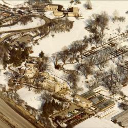
Aerial view of South Farm, Administration Building, and Visitor Center in winter (3.3147)
Date: 1970sCreator: Knoedler, Bob
Type: Photographic image
Description:Aerial view of South Farm, Administration Building, and Visitor Center in winter
Extent: 1 photograph

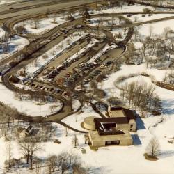
Aerial view of Visitor Center area (3.3632)
Date: 1973 – 1974Creator: Helmick, William K.
Type: Photographic image
Description:Aerial view of Visitor Center area
Extent: 1 photograph
Morton Arboretum [Aerial Photograph and] Conservation Plan Map, Kane-DuPage Soil Conservation District. (3.5416)
Date: June 1964Creator: U.S. Soil Conservation Service
Type: Map
Description:Photomosaic produced from aerial photographs believed to have been taken in the 1940s. "Photo nos. BWS-8N-11, 8N-12, 8N-13, 4N-63, 4N-64, 4N-65, 4N-66, &4N-67." The photograph has been marked in ink with water features and major highways.
Extent: 1 sheet
[Aerial photograph of] the Morton Arboretum (3.5438)
Date: March 25 1986Creator: Sidwell Company
Type: Photographic image
Description:Photographs taken from west to east; individual sheets overlap.
Extent: 5 sheets in binder
[Aerial survey of the proposed F.A.P. 431 ( North-South Tollway) road plan along the Morton Arboretum] (3.5852)
Date: circa 1983Type: Map
Description:Roadway added as line-drawing overlay to aerial survey.
Extent: 1 sheet
[Aerial Photograph of the Morton Arboretum] (3.6051)
Date: circa 1940Creator: Chicago Aerial Survey Co.
Type: Photographic image
Description:Photomosaic print mounted on masonite board.
Areas outlined in red.
Collection has reduction mounted on masonite (1 inch = 900 feet, 70 cm x 29 cm)
Extent: 1 sheet mounted
Milton Twp. Sec. 36 T39N - R10E, DuPage Co. (3.7010)
Date: April 1975Type: Map
Description:Written in pencil on left margin, "ARBORETUM." Written in pencil on top margin, DuPage River and Johnson Farm.
Extent: 1 sheet

Aerial view of entire East Side in winter (3.3148)
Date: 1970sCreator: Knoedler, Bob
Type: Photographic image
Description:Aerial view of entire East Side in winter
Extent: 1 photograph
[Aerial Photograph of the Morton Arboretum and Adjacent Areas pt. 1] (3.5417)
Date: circa 1961Type: Photographic image
Description:The 4 survey photos, taken as stereographic pairs, are identified as follows and show the areas noted: [1] BWS-2BB-204, East half of the Arboretum and Glen Ellyn; [2] BWS-2BB-206, Northwest portion of the Arboretum and Wheaton/Glen Ellyn; [3] BWS-3BB-86, Southeastern portion of the Arboretum and Downers Grove; [4] BWS-3BB-88, Major Southern portion of the Arboretum and Lisle.
Part 1
Extent: 1 sheet mounted on posterboard
[Aerial photograph of] the Morton Arboretum [Crabapple Lake] (3.5441)
Date: March 25 1986Creator: Sidwell Company
Type: Photographic image
Description:[Crabapple Lake] photographic enlargement
Extent: 1 sheet
F. A. P. Route 431 [North-South Tollway] proposed typical sections (3.5853)
Date: 1983Creator: McDonough Associates, Inc.
Type: Map
Description:A composite work consisting of road cross-sections (scale: horizontal, 1 inch = 20 feet and vertical, 1 inch = 10 feet) identified as C-C , D-D, E-E, F-F, G-G, and H-H. Specific cross-sectional locations are then shown on an accompanying aerial survey. (scale: 1 inch = 100 feet; 95x90 cm.) .
Extent: 6 sheets stapled
Hidden Lake Forest Preserve [Exhibit 1: Arboretum-Forest Preserve District Cooperative Research Program Space Study] (3.6090)
Date: April 1984Creator: Forest Preserve District of DuPage County
Type: Map
Description:Shows boundaries and acreage in the eastern half of the Arboretum made available to the Arboretum by the Forest Preserve District, and others made available to the Forest Preserve District by the Arboretum. Topography is shown. Copy 2 is a diazotype aerial photo with topographic lines dated April 1984.
Extent: 1 sheet
Morton Arboretum, DuPage County, Illinois (topographic survey) (3.6633)
Date: circa 1970Creator: Chicago Aerial Survey Co.
Type: Map
Description:"By stereo-photogrammetric methods. Project 7145."
Sheet one includes highlighted roads and parking lots.
With overlay by Coulter (sheet 2). Trace overlay includes areas marked in colored marker with Arboretum areas/features identified.
Extent: 2 sheets
Lisle Twp. Sec. 3 T38N - R10E DuPage Co. (3.6989)
Date: April 1975Type: Map
Description:Pencil notes: Ill. 53, Arboretum, East-West Tollway, Warrenville, Rd. Ogden.
Extent: 1 sheet

Aerial view of entire West Side in winter (3.3149)
Date: 1970sCreator: Knoedler, Bob
Type: Photographic image
Description:Aerial view of entire West Side in winter
Extent: 1 photograph
[Aerial Photograph of the Morton Arboretum and Adjacent Areas pt. 2] (3.5418)
Date: circa 1961Type: Photographic image
Description:The 4 survey photos, taken as stereographic pairs, are identified as follows and show the areas noted: [1] BWS-2BB-204, East half of the Arboretum and Glen Ellyn; [2] BWS-2BB-206, Northwest portion of the Arboretum and Wheaton/Glen Ellyn; [3] BWS-3BB-86, Southeastern portion of the Arboretum and Downers Grove; [4] BWS-3BB-88, Major southern portion of the Arboretum and Lisle.
Part 2
Extent: 1 sheet mounted on posterboard
[Aerial photograph of] the Morton Arboretum [South Farm] (3.5443)
Date: March 25 1986Creator: Sidwell Company
Type: Photographic image
Description:[South Farm] 2 photographic negatives
Extent: 2 sheets
North-South Tollway preliminary alignment (Ogden Avenue-Butterfield Road. Contractor) Envirodyne Engineers, Inc. (3.5860)
Date: February 21 1985Creator: Illinois State Toll Highway Authority
Type: Map
Description:Aerial survey with the preliminary alignment of the North-South Tollway with the East-West Tollway drawn in.
Extent: 2 sheets stapled
[Elevation Bench Marks on the Arboretum] (3.6110)
Date: May 1 1992Creator: Hootman, Rick
Type: Map
Description:Base map is a 1990 aerial photo of the Morton Arboretum prepared by the Sidwell Company of West Chicago, IL. Includes an 8.5"x11" sheet providing exact benchmark locations and elevations.
Extent: 5 sheets in binder
Morton Arboretum, DuPage County, Illinois (topographic survey) (3.6634)
Date: circa 1970Creator: Chicago Aerial Survey Co.
Type: Map
Description:"By stereo-photogrammetric methods. Project 7145."
Some shaded areas.
Extent: 2 sheets
The Morton Arboretum [topographic map] [Revised] (3.7125)
Date: 1990Creator: Sidwell Company
Type: Map
Description:Topographic data produced from aerial photography orginally made Dec.16,1985 (SURV: A III (c) 2) ; updated for the revision on April 25,1990. True elevations given. Includes Hidden Lake leased Plan.
Marked up by Marcus de la Fleur in preparation for a collections master plan. The library has the resultant plan in the archives on CD, 2001.
Extent: 5 sheets

Aerial view of South Farm in winter (3.3150)
Date: 1970sCreator: Knoedler, Bob
Type: Photographic image
Description:Aerial view of South Farm in winter
Extent: 1 photograph
[Aerial Photograph of the Morton Arboretum and Adjacent Areas pt. 3] (3.5419)
Date: circa 1961Type: Photographic image
Description:The 4 survey photos, taken as stereographic pairs, are identified as follows and show the areas noted: [1] BWS-2BB-204, East half of the Arboretum and Glen Ellyn; [2] BWS-2BB-206, Northwest portion of the Arboretum and Wheaton/Glen Ellyn; [3] BWS-3BB-86, Southeastern portion of the Arboretum and Downers Grove; [4] BWS-3BB-88, Major southern portion of the Arboretum and Lisle.
Part 3
Extent: 1 sheet mounted on posterboard
[Aerial photograph of] the Morton Arboretum [Willoway Creek] (3.5444)
Date: March 25 1986Creator: Sidwell Company
Type: Photographic image
Description:[Willoway Creek] 3 photographic negatives
Extent: 3 sheets
North-South Tollway preliminary plans [by] Envirodyne Engineers. Aerial photography by Aero-metric Engineering, Inc., photogrammetric engineers. (3.5861)
Date: March 1 1986Creator: Illinois State Toll Highway Authority
Type: Map
Description:Sheets numbered: "Drawing 1[-12] of 12," aerial photographs on which the roadway has been drawn in. Sheets 3, 5, 7, 9, and 11 are accompanied by roadway profiles numbered 3a, 5a, 7a, 9a, and 11a. Cover title. "Appendix A". Aerial survey made in November 1984.
Extent: 18 sheets
Soil and Woodland Suitability Map (3.6169)
Date: March 1965Creator: U.S. Soil Conservation Service
Type: Map
Description:Uses photo probably from mid 1950s
Extent: 1 sheet
Morton Arboretum, DuPage County, Illinois (topographic survey) (3.6635)
Date: November 19 1967Creator: Chicago Aerial Survey Co.
Type: Map
Description:"By stereo-photogrammetric methods. Project 7145."
Some colored marker, grid lines.
Extent: 2 sheets taped
Lisle Twp. Sec. 4 T38N - R10E DuPage Co. (3.6992)
Date: April 1978Type: Map
Description:Pen marks in upper right corner.
Extent: 1 sheet
[Aerial photograph of] The Morton Arboretum (3.7126)
Date: April 1986Creator: Sidwell Company
Type: Photographic image
Extent: 6 sheets in binder
Aerial view of Visitor Center & Main Parking Lot in winter (3.3151)
Date: 1970sCreator: Knoedler, Bob
Type: Photographic image
Description:Aerial view of Visitor Center & Main Parking Lot in winter
Extent: 1 photograph
[Aerial Photograph of the Morton Arboretum and Adjacent Areas pt. 4] (3.5420)
Date: circa 1961Type: Photographic image
Description:The 4 survey photos, taken as stereographic pairs, are identified as follows and show the areas noted: [1] BWS-2BB-204, East half of the Arboretum and Glen Ellyn; [2] BWS-2BB-206, Northwest portion of the Arboretum and Wheaton/Glen Ellyn; [3] BWS-3BB-86, Southeastern portion of the Arboretum and Downers Grove; [4] BWS-3BB-88, Major southern portion of the Arboretum and Lisle.
Part 4
Extent: 1 sheet mounted on posterboard
DuPage County and Part of Cook County, Illinois: Sheet Number 67 [and] Sheet Number 68 [of Soil survey of DuPage and part of Cook Counties, Illinois] (3.5449)
Date: 1979Creator: U.S. Soil Conservation Service
Type: Map
Description:The overall work, Soil survey of DuPage and part of Cook Counties, Illinois, from which these maps are extracted, was issued in 1979 as Illinois Agricultural Experiment Station Report no. 108. The maps are compiled from aerial photography carried out in 1970 and 1971. Sheet no.67 shows the western portion of the Arboretum and adjacent areas, and sheet no. 68 shows the eastern portion of the Arboretum and surrounding areas.
Extent: 2 maps - 1 on recto and 1 on verso of 1 sheet