
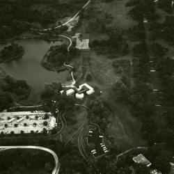
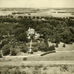
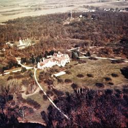
Aerial view of entire Morton Farm and estate (relay tower in distance) (3.3143)
Creator: Curtiss-Wright
Type: Photographic image
Description:Photograph taken during an aerial survey depicting entire Morton farm and estate (relay tower in distance)
Extent: 1 photograph
Aerial view of Visitor Center & proposed path from Administration Bldg. (3.3145)
Date: 1973 – 1974Creator: Helmick, William K.
Type: Photographic image
Description:Aerial view of Visitor Center & proposed path from Administration Bldg.
Extent: 1 photograph (2 copies)
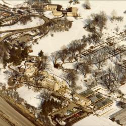
Aerial view of South Farm, Administration Building, and Visitor Center in winter (3.3147)
Date: 1970sCreator: Knoedler, Bob
Type: Photographic image
Description:Aerial view of South Farm, Administration Building, and Visitor Center in winter
Extent: 1 photograph

Aerial view of entire East Side in winter (3.3148)
Date: 1970sCreator: Knoedler, Bob
Type: Photographic image
Description:Aerial view of entire East Side in winter
Extent: 1 photograph

Aerial view of entire West Side in winter (3.3149)
Date: 1970sCreator: Knoedler, Bob
Type: Photographic image
Description:Aerial view of entire West Side in winter
Extent: 1 photograph

Aerial view of South Farm in winter (3.3150)
Date: 1970sCreator: Knoedler, Bob
Type: Photographic image
Description:Aerial view of South Farm in winter
Extent: 1 photograph
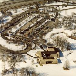
Aerial view of Visitor Center & Main Parking Lot in winter (3.3151)
Date: 1970sCreator: Knoedler, Bob
Type: Photographic image
Description:Aerial view of Visitor Center & Main Parking Lot in winter
Extent: 1 photograph
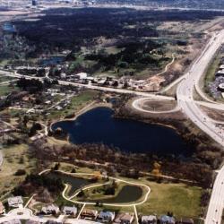
Aerial view of Arboretum and surrounding area (3.3152)
Date: April 1990Creator: Patchett, James
Type: Photographic image
Description:Aerial view of Arboretum and surrounding area
Extent: 1 photograph
I-88 and Route 53 Intersection Turf Maintenance Plan (3.31970)
Date: July 15 2008Creator: Pelkonen, Peggy
Type: Plan
Extent: 1 sheet
I-88 and Route 53 Intersection Irrigation Plan (3.31971)
Date: March 10 2009Creator: Gravel, David, ehdd, inc.
Type: Plan
Extent: 1 sheet
[Retaining wall project] (3.31984)
Type: Plan
Description:Shows south edge of The Morton Arboretum along I-88 east of Route 53.
Extent: 1 sheet
Aerial view of Arbor Lodge (3.3290)
Date: 20th centuryCreator: Savage, John S.
Type: Photographic image
Description:Aerial view of Arbor Lodge
Extent: 1 photograph
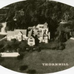
Morton Residence at Thornhill, aerial view (3.3455)
Type: Photographic image
Description:Morton Residence at Thornhill, aerial view
Extent: 1 photograph
The Morton Arboretum (3.35347)
Date: 1986Creator: Sidwell Company
Type: Map
Description:The maps shows images taken on December 16, 1985. The copyright date of the maps is 1986.
Extent: 5 sheets
The Morton Arboretum (3.35349)
Date: 1990Creator: Sidwell Company
Type: Map
Description:The maps show images taken on December 16, 1985 and also April 25, 1990. The copyright date of the maps is 1990.
These maps are part of a 5 sheet set, but sheet 5 is missing.
Extent: 4 sheets
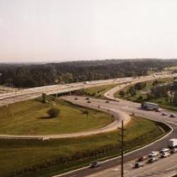
Route 53 Interchange, aerial view (3.3591)
Date: 1987Creator: Irving, Gary
Type: Photographic image
Description:Route 53 Interchange, aerial view
View from Warrenville Road looking east along I-88. The Morton Arboretum can be seen to the left of I-88.
Extent: 1 photograph

Aerial view of Thornhill Residence looking north amid Parsons Grove on west side of DuPage River (3.3628)
Creator: Curtiss-Wright
Type: Photographic image
Description:Photograph taken during an aerial survey depicting Thornhill Residence looking north amid Parsons Grove on west side of DuPage River
Extent: 1 photograph

Aerial view of Thornhill Residence and surrounding land (3.3629)
Creator: Curtiss-Wright
Type: Photographic image
Description:Photograph taken during an aerial survey depicting Thornhill Residence and surrounding land
Extent: 1 photograph

Aerial view of Visitor Center area (3.3632)
Date: 1973 – 1974Creator: Helmick, William K.
Type: Photographic image
Description:Aerial view of Visitor Center area
Extent: 1 photograph
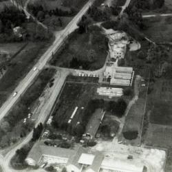
Aerial view of Administration Building, greenhouses, nursery, South Farm (3.38489)
Type: Photographic image
Description:Aerial view of Administration Building, greenhouses, nursery, South Farm
Extent: 1 filmstrip
Aerial view of Morton residence at Thornhill and surrounding area, looking north (3.38604)
Date: 1930sType: Photographic image
Description:Aerial view of Morton residence at Thornhill and surrounding area, looking north
Extent: 1 negative
The Morton Arboretum Master Site Plan (3.39966)
Type: Plan
Description:Aerial view of The Morton Arboretum colored in color pencil.
Prairie Visitor Station: Trail Development (3.40111)
Date: April 5 2004Creator: Pelkonen, Peggy
Type: Plan
Description:Trail development plan fro Prairie Visitor Station drawn over aerial photograph showing Sterling Pond, Acre Trail, Main Trail Loop 4, Savanna Trail, and Prairie Trail with trails mapped and named, located near Leask Lane.
Extent: 1 sheet
Prairie Visitor Station: Screening Plan (3.40114)
Date: June 20 2006Creator: Pelkonen, Peggy
Type: Plan
Description:An aerial image of the area surrounding the Prairie Visitor Station.
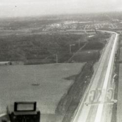
East/West Tollway construction near The Morton Arboretum, aerial view (3.44601)
Date: circa 1957Type: Photographic image
Description:East/West Tollway construction near The Morton Arboretum, aerial view
Extent: 1 filmstrip
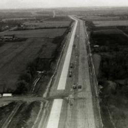
East/West Tollway construction near The Morton Arboretum, aerial view (3.44602)
Date: circa 1957Type: Photographic image
Description:East/West Tollway construction near The Morton Arboretum, aerial view
Extent: 1 filmstrip

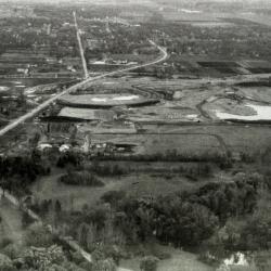
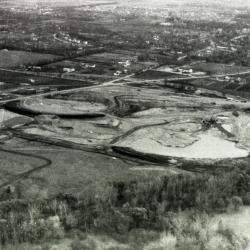
East/West Tollway and Arbor Lake construction, aerial view (3.44603)
Date: circa 1957Type: Photographic image
Description:East/West Tollway and Arbor Lake construction, aerial view
Extent: 1 filmstrip
Arbor Lake construction, aerial view (3.44604)
Date: circa 1957Type: Photographic image
Description:Arbor Lake construction, aerial view
Extent: 1 filmstrip
Arbor Lake construction, aerial view (3.44605)
Date: circa 1957Type: Photographic image
Description:Arbor Lake construction, aerial view
Extent: 1 filmstrip
Aerial Image of Cemetery Layout (3.47258)
Date: July 12 2005Creator: Pelkonen, Peggy
Type: Plan
Description:An aerial image with line drawings indicating the cemetery layout and surrounding paths and roads.
Extent: 1 Sheet
Concept Park Boulevard Entrance (3.47501)
Date: January 9 2001Creator: Christopher B. Burke, Engineering West, Ltd.
Type: Map
Description:Color aerial map showing existing entrance and exit to be removed and proposed entrance, exit, and parking facility in 2001.
"Project No. 00-910"
Extent: 1 Sheet
Morton Arboretum, DuPage County, Illinois (topographic survey) (3.5263)
Date: circa 1970Creator: Chicago Aerial Survey Co.
Type: Map
Description:"By stereo-photogrammetric methods. Project 7145."
Extent: 2 sheets
[Aerial Photograph of The Morton Arboretum] (3.5412)
Date: 1939Type: Photographic image
Description:The photos are individually identified as follows: BWS-1-72 through BWS-1-75 and BWS-3-11 through BWS-3-14. Each bears the date: 8-24-39; however, empty agricultural fields shown indicate that the exposures would have been made in the spring. The set was purchased in 1990 from the Agricultural Stabilization and Conservation Service (ASCS).
Extent: 8 sheets in envelope
[Aerial photograph of the Morton Arboretum] (3.5413)
Date: circa 1940Creator: Chicago Aerial Survey Co.
Type: Photographic image
Description:Photomosaic print mounted on masonite board.
Extent: 1 sheet
Morton Arboretum [Aerial Photograph and] Conservation Plan Map, Kane-DuPage Soil Conservation District. (3.5416)
Date: June 1964Creator: U.S. Soil Conservation Service
Type: Map
Description:Photomosaic produced from aerial photographs believed to have been taken in the 1940s. "Photo nos. BWS-8N-11, 8N-12, 8N-13, 4N-63, 4N-64, 4N-65, 4N-66, &4N-67." The photograph has been marked in ink with water features and major highways.
Extent: 1 sheet
[Aerial Photograph of the Morton Arboretum and Adjacent Areas pt. 1] (3.5417)
Date: circa 1961Type: Photographic image
Description:The 4 survey photos, taken as stereographic pairs, are identified as follows and show the areas noted: [1] BWS-2BB-204, East half of the Arboretum and Glen Ellyn; [2] BWS-2BB-206, Northwest portion of the Arboretum and Wheaton/Glen Ellyn; [3] BWS-3BB-86, Southeastern portion of the Arboretum and Downers Grove; [4] BWS-3BB-88, Major Southern portion of the Arboretum and Lisle.
Part 1
Extent: 1 sheet mounted on posterboard