
Urban Vegetation Laboratory Report V. 1 No. 1, 1988 (3.83045)
Date: March 21 – June 20 1988Type: Document
Description:In-house publication of the Morton Arboretum. This particular issue discusses the North-South Tollway, current grants, research, publications and objectives of the UVL.
Extent: 2 sheets, 1 folded
Morton Arboretum Lisle Ill. - Highway 88 sign (3.6822)
Date: October 9 1999Creator: Halloran & Yauch, Inc.
Type: Map
Description:Inset drawing: "Quick coupling valve installation." Also included: smaller drawing showing sign location in relation to Route 53 and South Farm area (scale 1 inch = 600 feet). "As-Built." "Sheet 1 of 2" - sheet 2 is missing
Extent: 1 sheet
Morton Arboretum Route 53 & 88 (3.6800)
Date: August 7 1995Creator: Halloran & Yauch, Inc.
Type: Map
Description:"As-Built 06-13-96"
Extent: 1 sheet
Subsurface Drain Tile Construction Plan for The Morton Arboretum (3.6791)
Date: February 26 1991Creator: Huddleston-McBride Co.
Type: Map
Description:Sheet 1 includes trench section for water table control and curtian drain mainline. Marked "Preliminary Plan." Sheet 2 is dated 7/29: "Drainage swale to topography and pipeline cross-sections along north edge of tollway berm: Centennial Grove to crabapples."
Extent: 2 sheets
Northwest pumping station force main; tollway crossing rehabilitation (3.6779)
Date: December 3 1982Creator: Wight & Company
Type: Map
Description:"Preliminary." Includes barricade detail, tree protection detail, location map, detail sheet showing scope of work at five stages, aerial survey, and existing profile.
Extent: 4 sheets stapled
Plat of Easement to the Village of Downers Grove, Illinois (3.6778)
Date: December 17 1968Creator: Wight & Company
Type: Map
Description:Survey shows area ceded by Arboretum to Downers Grove north of East-West Tollway and west of Finley Road. Includes grant of easement document describing six parcels and aerial photograph of area with red pencil notes.
Extent: 3 sheets
Morton Arboretum Lisle Ill. - Highway 88 sign (3.6770)
Date: October 9 1999Creator: Halloran & Yauch, Inc.
Type: Plan
Description:Inset drawing: "Quick coupling valve installation." Also included: smaller drawing showing sign location in relation to Route 53 and South Farm area (scale 1 inch = 600 feet). "As-Built." "Sheet 1 of 2" - sheet 2 is missing
Extent: 1 sheet
A Berm Detail for The Morton Arboretum [of the southern boundary] (3.6764)
Date: December 12 1986Creator: Tyznik, Anthony
Type: Map
Description:A revision of SURV:A III (c) 1 (3.6763)
Extent: 2 sheets
A Berm Detail for the Morton Arboretum [of the southern boundary] [ink drawing on parchment] (3.6763)
Date: February 1986Creator: Tyznik, Anthony
Type: Map
Description:Set of topographic maps giving berm elevations along the East-West Tollway from the Route 53 intersection to the eastern boundary of the Arboretum. Coverage of the area is given as follows: [1] Western section inclusive of the King's grove area; [2] Central section inclusive of the area into the East Woods; [3] Puffer marsh area.
Collection has a revised version of the Western section issued in June, 1988 and a CD scan by Pat Kelsey, 4-18-2006.
Extent: 3 sheets
Plat of Survey and Topographic Map [of Arboretum land south of East-West Tollway] [no topographics] (3.6754)
Date: March 25 1970Creator: Steinbrecher, Harold F.
Type: Map
Description:Plan shown in survey was annexed to the City of Lisle in 1972.
This map doesn't show topographics. See related objects for a link to the map with topographics.
Extent: 1 sheet
Site Identity Signs: IL Route 53 and IL Tollway 88 (3.6714)
Date: circa 2000Creator: Mehaffey, Scott A.
Type: Plan
Extent: 1 sheet
East-West Tollway [limited berm diagram] (3.67077)
Type: Document
Description:Diagram of a small portion of the Illinois East-West Tollway berm and its limiting effects on the Morton Arboretum.
Extent: 1 sheet
Berm Plan - West Section and East Section [03/1993, latest version] (3.6538)
Date: March 16 1993Creator: Tyznik, Anthony
Type: Plan
Description:West section is on sheets 1 and 2, east section on sheets 3-6.
Includes note: "copy with Bachtell's amendments, latest version March 16, 1993."
Missing sheet 6.
Extent: 5 sheets
Berm Plan - West Section and East Section [11/1992] (3.6537)
Date: November 17 – 19 1992Creator: Tyznik, Anthony
Type: Plan
Description:West section is on sheets 1 and 2, east section on sheets 3-6.
Extent: 6 sheets
A Landscape Development Plan for the Tollway Berm, West and East Sections, The Morton Arboretum [10/1992, colored, including pencil modifications] (3.6530)
Date: October 1992Creator: Tyznik, Anthony
Type: Plan
Description:Partially colored with colored pencil and includes pencil corrections.
Extent: 2 sheets
A Landscape Development Plan for the Tollway Berm, West and East Sections, The Morton Arboretum [10/1992] (3.6529)
Date: October 1992Creator: Tyznik, Anthony
Type: Plan
Extent: 2 sheets
A Landscape Development Plan for the Tollway Berm - West Section [10/1989, colored] (3.6527)
Date: October 1989Creator: Tyznik, Anthony
Type: Plan
Description:This copy includes colored pencil shading.
Extent: 2 sheets, attached with tape
A Landscape Development Plan for the Tollway Berm - West Section [10/1989] (3.6526)
Date: October 1989Creator: Tyznik, Anthony
Type: Plan
Extent: 2 sheets
A [Proposed] Landscape Screen Planting Plan for the Northern Illinois Gas Company Valve Nest (3.6454)
Creator: Tyznik, Anthony
Type: Plan
Description:East side near Commonwealth Edison tower; perhaps located south of East-West Tollway
Extent: 1 sheet
Tollway Right-of-Way and Easement at Morton Arboretum (3.6366)
Date: January 14 1988Creator: Illinois State Toll Highway Authority
Type: Map
Extent: 3 sheets
Subsurface Drain Tile Construction Plan for The Morton Arboretum (3.6353)
Date: February 26 1991Creator: Huddleston-McBride Co.
Type: Map
Description:Sheet 1 includes trench section for water table control and curtian drain mainline. Marked "Preliminary Plan." Sheet 2 is dated 7/27: "Drainage swale to topography and pipeline cross-sections along north edge of tollway berm: Centennial Grove to crabapples."
Extent: 2 sheets
Access map, Morton Arboretum (3.6331)
Date: 1989 – 1990Creator: Butkovich, Dianne
Type: Map
Extent: 1 sheet
Access map, Morton Arboretum (3.6330)
Date: 1989 – 1990Creator: Butkovich, Dianne
Type: Map
Extent: 1 sheet
Access map, Morton Arboretum (3.6329)
Date: 1989 – 1990Creator: Butkovich, Dianne
Type: Map
Extent: 1 sheet
Village of Lisle, Tollway Drainage Study [Revised] (3.6327)
Date: July 31 1981Creator: Lindley & Sons, Inc.
Type: Map
Description:C.2 lacks sheet one. Revised 1981-07-31. Additional changed marked in red.
Extent: 3 sheets, stapled
North-South Tollway - tunnel modifications, Contract CIP615A, Centerline Station 1150+00 to Station 1165 = 00, NW Ramp Station 57 + 50 to Station 63 + 50 (3.6288)
Date: circa 1993Creator: Illinois State Toll Highway Authority
Type: Map
Description:Tunnel located where North-South and East-West Tollways intersect. A few red pencil corrections.
Extent: 14 sheets stapled
Northern Illinois Toll Highway Parcel No. E-2-71E [and] E-2-71E.1, Sec. 3, T.38N., R.10E. of the 3rd P.M., DuPage County, Illinois (3.6095)
Date: May 1978Creator: Illinois State Toll Highway Authority
Type: Map
Description:Area surveyed, 0.206 acres, is a portion along the East-West Tollway easement in Lot 6 of Petersen-Tate Assessment Plat no. 2.
Extent: 4 sheets
Northern Illinois Toll Highway Parcel no. E-2-70E, Sec. 3, T.38N., R.10E. of the 3rd P.M., DuPage County, Illinois (3.6094)
Date: May 1978Creator: Illinois State Toll Highway Authority
Type: Map
Description:Area surveyed, 0.295 acres, is a portion along the East-West Tollway easement in Lot 7 of Petersen-Tate Assessment Plat no. 2.
Extent: 2 sheets
Northern Illinois Toll Highway Parcel No. E-2-68E [and E-2-68E.1], Sec. 3, T.38N., R.10E. of the 3rd P.M., DuPage County, Illinois (3.6093)
Date: May 1978Creator: Illinois State Toll Highway Authority
Type: Map
Description:Area surveyed, 0.313 acres, is a portion along the East-West Tollway easement in Lot 6 of Petersen-Tate Assessment Plat no. 2.
Extent: 3 sheets
Northern Illinois Toll Highway Parcel No. E-2-70, Sec. 3, T.38N., R.10E. of the 3rd P.M., DuPage County, Illinois (3.6092)
Date: 1956Creator: Illinois State Toll Highway Authority
Type: Map
Description:This map is a portion along the East-West Tollway easement in Lot 7 of Petersen-Tate Assessment Plat no. 2. This copy (Copy 2), dated from about 1956, includes surveyed area of 0.583 acres of the permanent easement.
Extent: 1 sheet
Highway improvements, vicinity of Morton Arboretum, and related Arboretum traffic system (3.6060)
Date: October 18 1956Creator: George W. Barton and Associates
Type: Map
Extent: 1 sheet
Crabapple Injury Assessment, East Malus Collection, The Morton Arboretum, 1984-1985 (3.6039)
Date: 1985Creator: Green, Tom
Type: Map
Extent: 1 sheet

Salt Study, view of snow-covered road along top of berm (3.58881)
Date: January 1993Creator: Nachel, Jim
Type: Photographic image
Description:Salt Study, view of snow-covered road along top of berm
Extent: 1 slide
[State Route 53 profile (Sta. 01-00 to Sta. 49+15.48), an engineering drawing for the widening and improving of the roadway] (3.5888)
Date: circa 1957Type: Map
Description:The Route 53 roadway extending from the East-West Tollway to the Valley View subdivision, showing re-routing of the road and the eastern branch of the DuPage River.
Extent: 2 sheets in binder
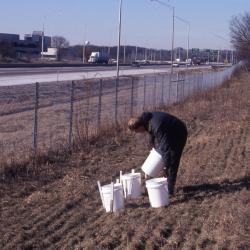
Salt Study, Rick Hootman with four white buckets on berm along I-88 (3.58879)
Date: February 1993Creator: Nachel, Jim
Type: Photographic image
Description:Salt Study, Rick Hootman with four white buckets on berm along I-88
Extent: 1 slide

Salt Study, Rose Reid and Rick Hootman placing white buckets on berm along I-88 (3.58878)
Date: February 1993Creator: Nachel, Jim
Type: Photographic image
Description:Salt Study, Rose Reid (left) and Rick Hootman (right) placing white buckets on berm along I-88
Extent: 1 slide