Browsing by year: object type:
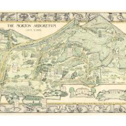
Morton Arboretum Map (3.19479)
Date: 1943Creator: Watts, May Theilgaard
Type: Map
Description:2014 reprint of The Morton Arboretum's first color map, circa 1943.
Detailed map of Arboretum grounds, showing roads, paths, landscaping, shelters, structures, enlargement of some specific features, hedge garden, some specific trees, and trails with markers numbered 1 - 42. Other features include a scale, a calendar, and a compass rose consisting of directions depicted with leaves. A highly ornamental border includes grid marks, as well as drawings of animal tracks and detailed drawings and labels of plants. The Morton Arboretum encompassed 813 acres at time of map.
Extent: 1 sheet

Morton Arboretum Map (3.19481)
Date: 1943Creator: Watts, May Theilgaard
Type: Map
Description:Detailed map of Arboretum grounds, showing roads, paths, landscaping, shelters, structures, enlargement of some specific features, hedge garden, some specific trees, and trails with markers numbered 1 - 42. Other features include a scale, a calendar, and a compass rose consisting of directions depicted with leaves. A highly ornamental border includes grid marks, as well as drawings of animal tracks and detailed drawings and labels of plants. Some replacement illustration and text has been adhered to the map. The Morton Arboretum encompassed 813 acres at time of map. One section is partially missing.
Extent: 1 sheet
Plat of Survey of that Part of the South East Quarter of Section 34, Township 39 North, Range 10 East of the Third Principal Meridian, Being Also Part of Assessment Plat No. 4, Lands Belonging to Trustees Under the Will of Joy Morton, Deceased, Milton Township, DuPage County, Illinois (3.5359)
Date: December 9 1943Creator: Steinbrecher, Harold F.
Type: Map
Description:Survey of 12.079 acres in the Thornhill area.
Extent: 1 sheet
Preliminary Drainage Investigations on the Mertz tract and the Mey Farm for Mr. Sterling Morton and the Estate of Joy Morton, Owners. (3.5583)
Date: 1940sCreator: Steinbrecher, Harold F.
Type: Map
Extent: 1 sheet
Plat of Survey of That Part of the South East Quarter of Section Thirty-three (33), Township Thirty-nine (39) North, Range Ten (10) East of the Third Principal Meridian in DuPage County, Illinois (3.6079)
Date: April 15 1943Creator: Steinbrecher, Harold F.
Type: Map
Extent: 1 sheet
[Topographic maps of the United States] Illinois topography… mapped, edited, and published by the Geological Survey in cooperation with State of Illinois Geological Survey (3.6552)
Date: 1922 – 1954Creator: Geological Survey (U.S.)
Type: Map
Description:Sheets 2-6 are same as REF:B I (a) 1 - REF:B II (b) 1. Sheet 1 - Belvedere Quadrangle - Illinois - Wisconsin. Sheet 2 - Herscher Quadrangle. Sheet 3 - Kankakee Quadrangle. Sheet 4 - Momence Quadrangle - Illinois - Indiana. Sheet 5 - Wilmington Quadrangle. Sheet 6 - Yorkville Quadrangle.
Extent: 6 sheets
Outline specifications for proposed private sewage disposal system at Parking Lot 5 - The Morton Arboretum (3.6793)
Date: 1940sType: Map
Description:Stone Cottage - later used as guard office, later as Plant Clinic. Pencil notes and revisions on all 3 copies.
Extent: 1 sheet
Outline specifications for proposed private sewage disposal system at Parking Lot 5 - The Morton Arboretum (3.6794)
Date: 1940sType: Map
Description:Stone Cottage - later used as guard office, later as Plant Clinic. Pencil notes and revisions on all 3 copies.
Extent: 1 sheet
Outline specifications for proposed private sewage disposal system at Parking Lot 5 - The Morton Arboretum (3.6795)
Date: 1940sType: Map
Description:Stone Cottage - later used as guard office, later as Plant Clinic. Pencil notes and revisions on all 3 copies.
Extent: 1 sheet
[Guide Map of The Morton Arboretum, Lisle, Illinois, 1940s?] (3.6814)
Date: 1940sCreator: Godshalk, Clarence E.
Type: Map
Description:Map mounted on cardboard, labels pasted on, no title, "C. Godshalk" on reverse.
Extent: 1 sheet