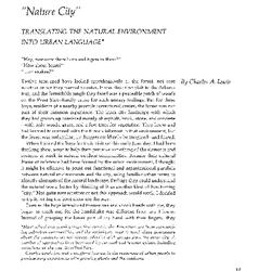
“Nature City”: Translating the Natural Environment into Urban Language (3.10714)
Date: June 21 – September 20 1975Creator: Lewis, Charles A.
Type: Article
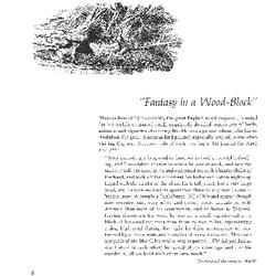
“Fantasy in a Wood-Block” (3.10680)
Date: March 21 – June 20 1974Creator: Doty, Carol L.
Type: Article

‘Frau Dagmar Hastrup’: A Rosa rugosa cultivar (3.11053)
Date: June 21 – September 20 1993Creator: Kalata, Lynne
Type: Article

Two young girls coloring on Coloring Mural during Arbor Week (3.55606)
Date: April 1994Creator: Nachel, Jim
Type: Photographic image
Description:Two young girls coloring on Coloring Mural during Arbor Week. Coloring mural designed by Anthony T. Byrne.
Extent: 1 slide
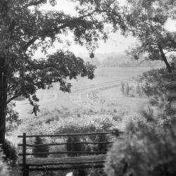
Looking south from Cedar Point over Iris test garden with wooden bench at edge of overlook in foreground (3.37820)
Date: 1930sType: Photographic image
Description:Looking south from Cedar Point over Iris test garden (now site of Arbor Vitae Collection, approx. P-22) with wooden bench at edge of overlook in foreground
The Morton Arboretum in conjunction with the American Iris Society maintained this iris test garden with over 900 different kinds of species.
Extent: 1 negative
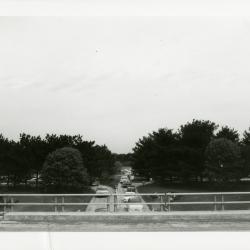
Sunday car traffic going under bridge (3.32055)
Date: 1960sType: Photographic image
Description:Sunday car traffic going under bridge
Extent: 1 photograph

Lake Marmo looking west toward islands (3.34023)
Date: 1920sType: Photographic image
Description:Lake Marmo looking west toward islands, wagon wheels in foreground on left
Extent: 1 negative
![[World's Fair Direction Map to Arboretum]](https://acorn.mortonarb.org/media/morton/images/2/2/0/34268_ca_object_representations_media_22019_iconlarge.jpg)
[World's Fair Direction Map to Arboretum] (3.7176)
Date: circa 1933Creator: Godshalk, Clarence E.
Type: Map
Description:Created for The Century of Progress Exposition, World's Fair Chicago 1933
Map showing roads to The Morton Arboretum, prior to tollways
Extent: 1 sheet
[World's Fair Direction Map to Arboretum, original drawing] (3.7175)
Date: circa 1933Creator: Godshalk, Clarence E.
Type: Map
Description:Created for The Century of Progress Exposition, World's Fair Chicago 1933
Map showing roads to The Morton Arboretum, prior to tollways
Extent: 1 sheet
[Wisconsin county maps] (3.6543)
Date: January 1964Creator: State Highway Commission of Wisconsin
Type: Map
Description:Sheet 1 - Kenosha County. Sheet 2 - Milwaukee county. Sheet 3 - Racine County. Sheet 4 - Walworth County. Sheet 5 - Waukesha County.
Extent: 5 sheets
[Water Line Locations Near Greenhouses in South Farm Nursery Areas] (3.6335)
Date: circa 1989Creator: Hootman, Rick
Type: Map
Extent: 1 sheet
[Visitor] Center Stair Fence Detail (3.6883)
Date: November 14 1978Creator: Tyznik, Anthony, Tyznik, Anthony
Type: Plan
Extent: 1 sheet
[Visitor Center, Audio-Visual Building, the Morton Arboretum] (3.5567)
Date: December 21 1970 – May 16 1972Creator: Myhrum, Arthur
Type: Plan
Description:Site plan, building layout, and audio-visual plans.
Extent: 6 sheets, stapled
[Visitor Center at the Morton Arboretum: Site Plans] (3.5554)
Date: July 21 1970 – March 31 1971Creator: Myhrum, Arthur
Type: Plan
Extent: 8 sheets
[Utilities Rights-of-Way in the Arboretum Along the East Boundary] (3.5613)
Date: August 1 1960Type: Map
Description:Revised 1960-08-01.
Extent: 1 sheet
[Township plat maps] (3.5899)
Date: January 1984Creator: DuPage County
Type: Map
Description:Set includes township plat maps for all townships in DuPage County except Addison Township.
Extent: 8 sheets
[Topographic maps of the United States] Wisconsin topography (3.7136)
Date: 1959 – 1960Creator: Geological Survey (U.S.)
Type: Map
Description:Eagle Quadrangle; Hales Corner Quadrangle; Lake Geneva Quadrangle; Silver Lake Quadrangle; Waukesha Quadrangle
Extent: 5 sheets
[Topographic maps of the United States] Illinois topography… mapped, edited, and published by the Geological Survey in cooperation with State of Illinois Geological Survey (3.6552)
Date: 1922 – 1954Creator: Geological Survey (U.S.)
Type: Map
Description:Sheets 2-6 are same as REF:B I (a) 1 - REF:B II (b) 1. Sheet 1 - Belvedere Quadrangle - Illinois - Wisconsin. Sheet 2 - Herscher Quadrangle. Sheet 3 - Kankakee Quadrangle. Sheet 4 - Momence Quadrangle - Illinois - Indiana. Sheet 5 - Wilmington Quadrangle. Sheet 6 - Yorkville Quadrangle.
Extent: 6 sheets
[Topographic map of the southern boundary area of the Arboretum showing the North-South Tollway right-of-way] (3.5862)
Date: October 1985Creator: Illinois State Toll Highway Authority
Type: Map
Extent: 10 sheets stapled
[Tollway Right-of-way and Easements Over the Southern Portion of the Thoman Farm] (3.5371)
Date: 1950sType: Map
Description:Acreages decicated to right -of-way are shown by colored shading. These data are shown on the composite survey copied by H.F. Steinbrecher from earlier plats titled: Plat showing the Thoman Farm, and issued ca. 1935.
Extent: 1 sheet
[Tollway Right-of-way and Easements in] Assessment Plat No. 2 (3.5370)
Date: 1950sType: Map
Description:Acreages dedicated to right-of-way are shown by colored shading. These data are shown on the plat made by J.S. Lozier and H.F. Steinbrecher titled: Assessment Plat No.2, and issued Oct.1, 1934.
Extent: 1 sheet
[Tollway Right-of-way and Easements Along Route 53 in] Assessment Plat No. 1 (3.5369)
Date: 1950sType: Map
Description:Acreages dedicated to right-of-way are shown by colored shading. These data are shown on the plat made by J.S. Lozier and H.F. Steinbrecher titled: Assessment Plat No. 1, and issued Sept.29, 1934.
Extent: 1 sheet
[Tollway Right-of-way and Easements Along Finley Road in] Assessment Plat No. 3 (3.5372)
Date: 1950sType: Map
Description:Acreages dedicated to right-of-way are shown by colored shading. These data are shown on the plat made by J.S. Lozier and H.F. Steinbrecher titled: Assessment plat no. 3, and issued Sept. 24, 1934.
Extent: 1 sheet
[Thornhill] Residence [Reinforcing Steel Architectural Plans for the Library Addition] (3.5540)
Date: October 3 1922Creator: Holabird & Root
Type: Plan
Extent: 6 sheets
[Thornhill South Patio Studies] (3.6951)
Date: circa 1992Creator: Tyznik, Anthony
Type: Plan
Description:Sheet 3 has two photocopy duplicates. Sheets 5 has a dizaotype duplicate and two photocopy duplicates. Sheets 6 and 7 have diazotype duplicates.
Extent: 7 sheets
[Thornhill Landscape Entrance Court - Early, Stone Selections and Dimensions] (3.6979)
Date: May 12 1992Creator: Tyznik, Anthony
Type: Plan
Description:Includes entrance court only, showing stone selections and dimensions
Extent: 1 sheet
[Thornhill Landscape Entrance Court - Early, Revised] (3.6534)
Date: May 12 1992Creator: Tyznik, Anthony
Type: Plan
Description:Revised edition of April 14, 1992 version.
Extent: 1 sheet
[Thornhill Landscape Entrance Court - Early, Colored] (3.6535)
Date: April 14 1992Creator: Tyznik, Anthony
Type: Plan
Description:Copy has sections colored in with colored pencil
Extent: 1 sheet
[Thornhill Landscape Entrance Court - Early, Additional Planting/Seating Detail] (3.6978)
Date: May 18 1992Creator: Tyznik, Anthony
Type: Plan
Description:Includes additional notes for planting and seating around the Entrance Court
Extent: 1 sheet
[Thornhill House] Details of New Metal Windows on South Elevation of Lecture Hall (3.5550)
Date: August 18 1954Creator: Holabird & Root
Type: Plan
Description:Sheet numbered A-1 (Note: Stapled with Morton memorial panels, see STRU: F II (b) 4a( Accession number 1031))
Extent: 1 sheet
[Thornhill Handicap Parking Lot and Ramp] (3.6739)
Date: 1992Creator: Tyznik, Anthony
Type: Plan
Description:Proposal was not used.
Does not include proposed plantings like copy 1.
Extent: 1 sheet
[Thornhill Handicap Parking Lot and Ramp with Proposed Planting] (3.6738)
Date: 1992Creator: Tyznik, Anthony
Type: Plan
Description:Proposal was not used.
Extent: 1 sheet

[Thornhill Forecourt] (3.44231)
Date: 1990sCreator: Mehaffey, Scott A.
Type: Drawing
Description:Concept drawing of the forecourt in front of the Thornhill Education Center. Includes drawing of the Raintree Fountain.
[Thornhill Forecourt Fountain Plan] (3.6868)
Date: circa 1980Creator: Myhrum, Arthur
Type: Plan
Description:Job listed as "Arboretum - Art Institute"
Includes handwritten notes on separate sheet of paper.
Extent: 1 sheet