Browsing by Subject/Keyword: collection:
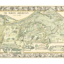
Morton Arboretum Map (3.19479)
Date: 1943Creator: Watts, May Theilgaard
Type: Map
Description:2014 reprint of The Morton Arboretum's first color map, circa 1943.
Detailed map of Arboretum grounds, showing roads, paths, landscaping, shelters, structures, enlargement of some specific features, hedge garden, some specific trees, and trails with markers numbered 1 - 42. Other features include a scale, a calendar, and a compass rose consisting of directions depicted with leaves. A highly ornamental border includes grid marks, as well as drawings of animal tracks and detailed drawings and labels of plants. The Morton Arboretum encompassed 813 acres at time of map.
Extent: 1 sheet

Morton Arboretum Map: Preliminary Drawing for Colored Map (3.19480)
Date: 1943Creator: Watts, May Theilgaard
Type: Drawing
Description:Preliminary drawing for detailed colored map of Arboretum grounds that was printed in 1943, showing roads, paths, landscaping, shelters, enlargement of some specific features, hedge garden, and center of hedge garden. Blank spaces indicate water and text placement. Tree symbols show exceptional specimens on east and west sides. The Morton Arboretum encompassed 813 acres at time of map. Drawing is in two pieces.
Extent: 2 sheets

Morton Arboretum Map (3.19481)
Date: 1943Creator: Watts, May Theilgaard
Type: Map
Description:Detailed map of Arboretum grounds, showing roads, paths, landscaping, shelters, structures, enlargement of some specific features, hedge garden, some specific trees, and trails with markers numbered 1 - 42. Other features include a scale, a calendar, and a compass rose consisting of directions depicted with leaves. A highly ornamental border includes grid marks, as well as drawings of animal tracks and detailed drawings and labels of plants. Some replacement illustration and text has been adhered to the map. The Morton Arboretum encompassed 813 acres at time of map. One section is partially missing.
Extent: 1 sheet