Browsing by people, organizations and landmarks: year:

Vegetation of the Chicago Region as Mapped by the Public Land Survey 1821-1845 (3.113833)
Date: 2014Creator: Halsey, Sam, McBride, Jenny
Type: Map
Description:A map created in 2006 portraying vegetation of the Chicago Region from 1821-1845.
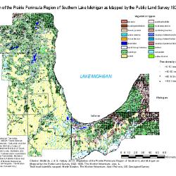
Historic Vegetation Maps (3.91112)
Date: 2014 – 2015Creator: McBride, Jenny, Halsey, Sam
Type: Document
Description:Maps of the Chicago region showing historic vegetation as mapped by the Public Land Survey, 1829-1845. Areas include northeastern Illinois, parts of Wisconsin, Indiana, and Michigan, and a map showing the whole region.