View of Meadow lake from restaurant windows [graphic]. (3.24250)
Date: 1980sCreator: Ellison, Marilyn
Type: Drawing
Extent: 1 drawing : pen and ink, b&w image 19 x 70 cm., on sheet 21 x 73 cm.
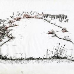
Lake scene landscape [graphic] / Nancy S. Hart Stieber. (3.24396)
Date: 1998Creator: Hart, Nancy
Type: Drawing
Extent: 1 drawing : pen and ink, b&w image 18 x 12 cm., on board 21 x 20 cm.
Crabapple Lake in landscape (3.24409)
Date: 1999Creator: Hart, Nancy
Type: Drawing
Description:Outline of Crabapple Lake, view from road, plants and trees sketched on edge of lake.
Extent: 1 drawing
Bottom sediment accumulation : broader vegetation zones / AB. (3.29270)
Date: 1986Creator: Byrne, Anthony T.
Type: Painting
Extent: 1 painting : acrylic, color 56 x 72 cm.
Woodland pond, summer (3.29274)
Date: 2003Creator: Byrne, Anthony T.
Type: Painting
Extent: 1 painting : acrylic, color image 44 x 77 cm., on board 56 x 82 cm.

"Winter Vista - Morton Arboretum" lake scene (3.2994)
Type: Photographic image
Description:"Winter Vista - Morton Arboretum" lake scene
Extent: 1 photograph
Tadpoles in Wonder Pond (3.31630)
Date: May 11 2012Type: Video
Site Improvement Plans for The Morton Arboretum Arbor Court & Maze Garden (3.31985)
Date: January 22 2003Creator: Christopher B. Burke, Engineering West, Ltd.
Type: Plan
Description:Includes overall plan, existing conditions, stormwater pollution prevention, soil erosion and sedimentation control, and grading and utility plans.
Extent: 8 sheets

Looking west from lower pond by Joy Path (3.3490)
Date: March 30 1921Type: Photographic image
Description:Looking west from lower pond by Joy Path
Extent: 1 photograph
East Branch Detention Facility Preliminary Plan (3.44619)
Date: May 23 2002Creator: Christopher B. Burke, Engineering West, Ltd.
Type: Plan
Description:Topographical survey of East Branch Detention Facility showing proposed future road. Trees not shown.
"Project No. 00-927A"
Extent: 1 sheet
Topographic Sketch of Morton Arboretum, Lisle, Illinois (3.5243)
Date: August 1921Creator: O. C. Simonds & Co.
Type: Map
Description:Conceptual oxbow ponds/wetlands along East Branch of the DuPage River are indicated.
Extent: 1 sheet
Topographic Sketch of Morton Arboretum, Lisle, Illinois [handwritten notes] (3.5244)
Date: August 1921Creator: O. C. Simonds & Co.
Type: Map
Description:Native woodland cover is shown by colored shading. Conceptual oxbow ponds/wetlands along East Branch of the DuPage River are indicated. Ms. Note by C.E. Godshalk: "This must have been Mr. Simond's 1st idea…." He has drawn in original Lisle, Illinois Farm buildings.
This copy has notes and markings.
Extent: 1 sheet
The Morton Arboretum General Information [1950? with additional area drawn in on guide map] (3.5779)
Date: circa 1950Type: Document
Description:Copy of The Morton Arboretum General Information leaflet, with Guide Map, an issuance in the Arboretum's informal series currently titled: Map & visitor guide, printed on both sides. Guide map printed on back of sheet and includes additional area drawn in pencil including Shrub Collection, Hedges, Nursery, Brush, and Pasture.
Extent: 1 sheet
A Guide Map of The Morton Arboretum, Lisle, Illinois [1958? with roads and parking colored] (3.5780)
Date: circa 1958Creator: Tyznik, Anthony
Type: Map
Description:The map was probably designed for collateral use in the Arboretum's informal series titled: Map & visitor guide. Roads showing direction of traffic and parking areas have been colored in with colored pencil.
Extent: 1 sheet
Woody Plant Collections, The Morton Arboretum [by Ronald M. Coulter and Nancy Hart Stieber] (3.5809)
Date: 1982Creator: Coulter, Ronald M.
Type: Map
Description:The map (in color) appears on the verso of the informational flier titled: Woody Plant Collections of The Morton Arboretum: Map & Guidelines for Locating Plants. On recto of flier a narrative description of the collections is given, together with directions on how to locate plants using the collections grid, and index to the collections. Various sizes and formats of the map only are available in the collection: reproductions on paper and in transparency and photographic negatives (various sizes, scales, and formats).
Extent: 1 sheet
Woody Plant Collections, The Morton Arboretum [Collections Grid by Ronald M. Coulter and Anthony Tyznik, version not used] (3.5816)
Date: 1982Creator: Coulter, Ronald M.
Type: Map
Description:A preliminary and/or provisional version of the Woody Plant Collections Guide Map which was never formally issued. The map developed by Coulter and Nancy Hart Stieber in 1982 was issued as the Arboretum's guide to woody plant collections.
Extent: 1 sheet
Map and Visitor Guide The Morton Arboretum [by Nancy Hart Stieber and John Sosnowski] (3.5818)
Date: 1984Creator: Hart, Nancy
Type: Document
Description:Leaflet created for the informal series titled: Map & Visitor Guide. On the recto of the leaflet an inset map (1 inch=1/2 mile) shows major Arboretum structures and connecting roads; also given is a summary of the Arboretum's history, public facilities and services, and regulations. Updated in 1989 with Crabapple Lake.
Extent: 1 sheet printed on both sides
Map and Visitor Guide [of] The Morton Arboretum [by Nancy Hart Stieber and John Sosnowski, various sections broken down into multiple negatives] (3.5819)
Date: 1984Creator: Hart, Nancy
Type: Map
Description:Seven photographic negatives depicting various sections of the map portion for the production of the Map & Visitor Guide. Updated in 1989 with Crabapple Lake.
Extent: Envelope with 7 film negatives
Map and Visitor Guide [of] The Morton Arboretum [by Nancy Hart Stieber and John Sosnowski enlarged sections of landmarks and vegetation] (3.5821)
Date: 1984Creator: Hart, Nancy
Type: Map
Description:Enlarged sections of landmarks and vegetation of the map portion of the Map & Visitor Guide created for production. Updated in 1989 with Crabapple Lake.
Extent: Folio of 12 items
Woody Plant Collections, The Morton Arboretum, Map & Guidelines for Locating Plants [1990] (3.5822)
Date: 1990Creator: The Morton Arboretum
Type: Document
Description:Informational leaflet published by The Morton Arboretum, printed on both sides of single folded sheet, with text describing the Woody Plant Collections, the catalog, how to use the map and grid on reverse side, and how to read plant labels.
Extent: 1 sheet
Woody Plant Collections, The Morton Arboretum [Collections Grid, by Ronald M. Coulter and Nancy Hart Stieber, 1990, overlays for vegetation, trails, grid, and landmarks] (3.5824)
Date: 1990Creator: Coulter, Ronald M.
Type: Map
Description:An updated map used in the informational leaflet titled: Woody Plant Collections of The Morton Arboretum, Map & Guidelines for Locating Plants
This version is a set of four mylar overlays, separating vegetation, trails, grid layout, and landmarks/collections.
Extent: 4 sheets
Hidden Lake Forest Preserve: proposed site & grading plan (3.5835)
Date: July 1 1983Creator: Ralph F. Gross & Son Associates, Inc.
Type: Map
Description:A portion of the Forest Preserve land parcel is leased by the Arboretum as a part of the Illinois State Toll Highway agreement of 1985. For a representation of the area leased, see DuPage County. Forest Preserve District. Hidden Lake Forest Preserve ... Arboretum-Forest Preserve District cooperative research program space study (SURV:B VI (c) 1).
Extent: 1 sheet
Proposed topsoil stockpile area, Hidden Lake Forest Preserve (3.5836)
Date: August 28 1984Creator: Forest Preserve District of DuPage County
Type: Map
Description:Shows an area of the Forest Preserve bordering on the intersection of Route 53 and Butterfield on the northwest. None of the area is leased to nor contiguous with the Arboretum.
Extent: 1 sheet
Tollway wetland and lake development, Hidden Lake Forest Preserve (3.5837)
Date: June 17 1986Creator: Forest Preserve District of DuPage County
Type: Map
Description:Shows the area bordering on the intersection of Route 53 and Butterfield Road on the northwest.
Extent: 1 sheet
[Hidden Lake Forest Preserve, topographic survey] (3.5838)
Date: circa 1985Creator: Sidwell Company
Type: Map
Description:The topographic base map survey by Sidwell Company was completed May 2, 1975. Shown are proposed lakes, a part of the Urban Vegetation Laboratory, and the boundary of forest preserve land leased to the Arboretum; these features are drawn in with ink.
Extent: 1 sheet
A Guide Map of The Morton Arboretum, Lisle, Illinois [1958? with written notes on road development] (3.5995)
Date: circa 1958Creator: Tyznik, Anthony
Type: Map
Description:Probably prepared for collateral use in the Arboretum's informal series titled: Map & Visitor Guide.
Includes misc notes by C.E. Godshalk on road building and lakes.
Extent: 1 sheet
A Guide Map of The Morton Arboretum, Lisle, Illinois [1958? with written notes on major planting dates since 1922] (3.5996)
Date: circa 1958Creator: Tyznik, Anthony
Type: Map
Description:Probably prepared for collateral use in the Arboretum's informal series titled: Map & Visitor Guide.
Includes misc notes by C.E. Godshalk on major planting dates since 1922 for various collections and landmarks.
Extent: 1 sheet
A Guide Map of The Morton Arboretum, Lisle, Illinois [1958? with written notes regarding land purchases and use] (3.5997)
Date: circa 1958Creator: Tyznik, Anthony
Type: Map
Description:Probably prepared for collateral use in the Arboretum's informal series titled: Map & Visitor Guide.
Includes misc notes by C.E. Godshalk regarding land purchases and use.
Extent: 1 sheet
A Guide Map of The Morton Arboretum, Lisle, Illinois [1965?] (3.6118)
Date: circa 1965Creator: Tyznik, Anthony
Type: Map
Description:Prepared for the series "Map & Visitor Guide." Possibly the original drawing for 1970 map incorporated into Map & Visitor Guide.
Extent: 1 sheet
[Marmo Bridge] (3.6265)
Creator: Tyznik, Anthony
Type: Plan
Description:Plan and elevation. Note on back: "Marmo Bridge."
Extent: 1 sheet
East Branch Valley View project area (3.6286)
Date: June 5 1995Creator: Department of Environmental Concerns
Type: Map
Extent: 1 sheet
Valley View area, Eagle Lake alternative (3.6287)
Date: July 11 1995Creator: Department of Environmental Concerns
Type: Map
Extent: 1 sheet
Woody Plant Collections, The Morton Arboretum [Collections Grid, by Ronald M. Coulter and Nancy Hart Stieber, 1990, colored with mowing schedule] (3.6293)
Date: 1990Creator: Coulter, Ronald M.
Type: Map
Description:An updated map used in the informational leaflet titled: Woody Plant Collections of The Morton Arboretum, Map & Guidelines for Locating Plants
This version is hand colored and labeled to show mowing schedule.
Extent: 1 sheet
Bridge for Morton Arboretum (3.6372)
Date: August 22 1921Creator: O. C. Simonds & Co.
Type: Plan
Description:Plan (damaged) for Lake Marmo dam and bridge.
Extent: 1 sheet
[Crabapple Lake Landscape Placement] (3.6443)
Date: 1988Creator: Tyznik, Anthony
Type: Map
Extent: 1 sheet
Map and Visitor Guide [of] The Morton Arboretum [by Nancy Hart Stieber and John Sosnowski, landmarks and vegetation portion] (3.6533)
Date: 1984Creator: Hart, Nancy
Type: Map
Description:Transparencies used in production of the flier showing landmarks/collections and vegetation to be used in the map portion of the informal series titled: Map & Visitor Guide. Updated in 1989 with Crabapple Lake.
Extent: Envelope with 2 items