Letter from Jens Jensen to Mayor of Chicago, Kelly (3.2691)
Date: April 7 1934Creator: Jensen, Jens
Type: Document
Description:Letter from Jens Jensen to Mayor of Chicago, Kelly
Amanitopsis vaginata (3.29210)
Date: 1920 – 1950Creator: Beggs, Helene Warder, 1882-1970
Type: Painting
Extent: 1 painting : watercolor and graphite 26 x 21 cm.
Cortinarius purpurascens (3.29231)
Date: 1920 – 1950Creator: Beggs, Helene Warder, 1882-1970
Type: Painting
Extent: 1 painting : watercolor and graphite 26 x 21 cm.
Marasmius oreades (3.29248)
Date: 1920 – 1950Creator: Beggs, Helene Warder, 1882-1970
Type: Painting
Extent: 1 painting : watercolor and graphite 26 x 21 cm.
Volvaria speciosa (3.29265)
Date: 1920 – 1950Creator: Beggs, Helene Warder, 1882-1970
Type: Painting
Extent: 1 painting : watercolor and graphite 26 x 18 cm.

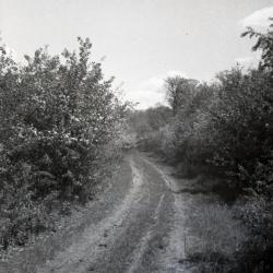
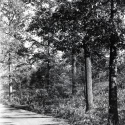
Meadow or Forest Road in winter (3.31938)
Date: 1930sType: Photographic image
Description:Meadow or Forest Road in winter
Extent: 1 negative filmstrip

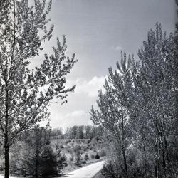
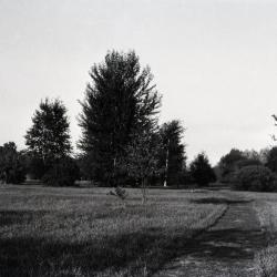
Unpaved Arboretum road through woods with open area in distance (3.32127)
Date: 1930sType: Photographic image
Description:Unpaved Arboretum road through woods with open area in distance
Extent: 1 negative
Simonds Road and road to Lake Marmo, view toward Malus Collection (3.32740)
Date: 1934Type: Photographic image
Description:Simonds Road and road to Lake Marmo, view toward Malus Collection
Extent: 1 negative
Ridge Road in winter through bare trees looking east (3.32759)
Date: 1930 – 1949Type: Photographic image
Description:Ridge Road in winter through bare trees looking east
Extent: 1 negative

Overlook on Ridge Road (3.32767)
Date: 1930 – 1949Type: Photographic image
Description:Overlook on Ridge Road
Extent: 1 negative

Meadow Road looking north (3.32779)
Date: 1930 – 1949Type: Photographic image
Description:Meadow Road looking north
Extent: 1 negative
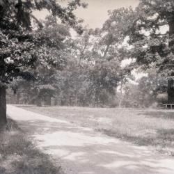
Drive through the oaks (3.33190)
Date: 1922 – 1949Type: Photographic image
Description:Drive through the oaks
Extent: 1 negative
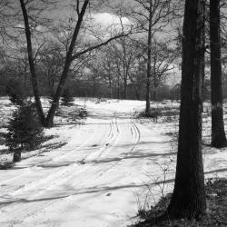
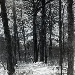
Forest Road covered with snow in winter (3.33203)
Date: 1930 – 1949Type: Photographic image
Description:Forest Road covered with snow in winter
Original Jake Mey land
Extent: 1 negative
European group west of DuPage River and east of Simonds Road (3.33291)
Date: 1930sType: Photographic image
Description:European group west of DuPage River and east of Simonds Road
Extent: 1 negative

Path along west end of Lake Marmo (3.33759)
Date: 1930 – 1949Type: Photographic image
Description:Path along west end of Lake Marmo
Extent: 1 negative
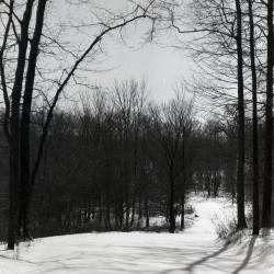
East side nature trail in winter (3.33770)
Date: 1930 – 1949Type: Photographic image
Description:East side nature trail in winter
Extent: 1 negative

Road along early Prunus Group, east of DuPage River (3.33979)
Date: 1930sType: Photographic image
Description:Road along early Prunus Group, east of DuPage River - road no longer there
Extent: 1 negative

Farm workers, South Farm (3.3611)
Date: 1930sType: Photographic image
Description:Farm workers, South Farm
L to R: Marty Hatch, Gerald Smith
Extent: 1 photograph
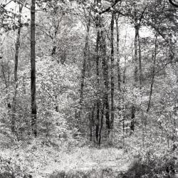
Cornus florida (flowering dogwood) in forested area in summer (3.37859)
Date: 1930 – 1949Type: Photographic image
Description:Cornus florida (flowering dogwood) in forested area in summer
Extent: 1 negative

Second Arboretum residence built for Clarence Godshalk in the 1930s, rear exterior view, prior to high roof addition (3.38214)
Date: 1930sType: Photographic image
Description:Second Arboretum residence built for Clarence Godshalk in the 1930s, rear exterior view, prior to high roof addition
Extent: 1 photograph

South view across lawn of Morton residence with hedge (3.38606)
Date: 1930sType: Photographic image
Description:South view across lawn of Morton residence with hedge
Extent: 1 negative
Plat of Dedication for Public Highway, Sections 33 & 34, T.39N. & Section 3, T.38N., R.10E. of the 3rd P.M., S.B. 1 Route 53, const. sec.534-X, DuPage County. (3.5299)
Date: November 1 1934Creator: Illinois Division of Highways
Type: Map
Description:"Tract 1, Joy Morton; Area: 1.136 acres." The survey identified the Route 53 right-of-way on the eastern roadside within the Arboretum.
Collection has additional plats on mylar detailing the subsections of the overall right-of-way.
70 (3.5300) and 71 (3.5301)
Extent: 1 sheet
[Proposed Landscape Design of the Morton] Burial Plot (3.60316)
Date: circa 1934Creator: Godshalk, Clarence E.
Type: Plan
Description:Planting plan and design for burial plot
Extent: 1 sheet
Four large mushrooms and a button / Helene Beggs 1945. (3.29232)
Date: 1920 – 1950Creator: Beggs, Helene Warder, 1882-1970
Type: Painting
Extent: 1 painting : watercolor and graphite 41 x 31 cm.
Morchella conica / Helene Beggs. (3.29249)
Date: 1920 – 1950Creator: Beggs, Helene Warder, 1882-1970
Type: Painting
Extent: 1 painting : watercolor and graphite 27 x 20 cm.
Old unpaved service road looking east (3.32112)
Date: 1930sType: Photographic image
Description:Old unpaved service road looking east
*located at about 96-C on Arboretum map/grid
Extent: 1 negative

Unpaved Arboretum road through wooded area curving left (3.32128)
Date: 1930sType: Photographic image
Description:Unpaved Arboretum road through wooded area curving left
Extent: 1 negative
Trees in October alongside Ridge Road (3.32768)
Date: 1930 – 1949Type: Photographic image
Description:Trees in October alongside Ridge Road
Extent: 1 negative
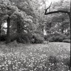
Thornhill residence grounds along Iris Path, man near iris plantings (3.33293)
Date: 1930sType: Photographic image
Description:Thornhill residence grounds along Iris Path, man near iris plantings
Extent: 1 negative
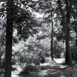
Trail in summer near Thornhill residence, west side (3.33441)
Date: 1930 – 1949Type: Photographic image
Description:Trail in summer near Thornhill residence, west side
Grassy path through trees
Extent: 1 negative
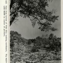
View from bottom of Pine Hill looking northeast (3.37791)
Date: 1930sType: Photographic image
Description:View from bottom of Pine Hill looking northeast
Big maple by Lake Marmo in center of picture
Extent: 1 photograph
Plat of Dedication for Public Highway, Section 34, T39N., R10E., Section 3, T 38N., R10E. of the 3rd P.M., S.B. 1. Route 53, const. sec.534-X, DuPage County (3.5300)
Date: December 21 1934Creator: Illinois Division of Highways
Type: Map
Description:Additional plat on mylar detailing the subsections of the overall right -of-way: 0.815 acres
Extent: 1 sheet
Burial Plot Belonging to Sterling Morton, Jean Morton Cudahy, and Margaret Gray Morton; Part of the SE 1/4 of Section 34, Township 39N. Range 10E. of the Third Principal Meridian (3.5334)
Date: October 2 1934Creator: Lozier, J. S.
Type: Map
Description:Survey of a tract in the Thornhill area.
Includes measurements in pencil.
Extent: 1 sheet
Our Native Landscape, May 1934 (3.67216)
Date: 1934Type: Serial
Description:This document can be made available at the Sterling Morton Library. To make an appointment, contact the Sterling Morton Library staff by following the link here.
Boletinus porosus (3.29213)
Date: 1920 – 1950Creator: Beggs, Helene Warder, 1882-1970
Type: Painting
Extent: 1 painting : watercolor and graphite 35 x 25 cm.
Four mushroom clump (3.29233)
Date: 1920 – 1950Creator: Beggs, Helene Warder, 1882-1970
Type: Painting
Extent: 1 painting : watercolor and graphite 24 x 15 cm.