Browsing by people, organizations and landmarks: year:
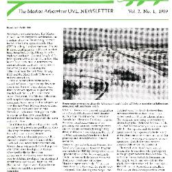
Urban Vegetation Laboratory Report, V2. 2 No. 1, 1989 (3.106912)
Date: March 21 – June 20 1989Creator: Irving, Gary, Hart, Nancy , Joseph Larken, Larkin, Joe
Type: Document
Description:Newsletter of the Morton Arboretum Urban Vegetation Laboratory. Items covered in this issue:
Arboretum Berm Construction
Certification for Soil Scientist Patrick Kelsey
Member's Cooperative Research Program
Poplars for Use on Urban Landscapes
Oak Mycorrhizae
Tree Crown and Root System Asymmetry
Winter Salt Dispersion in the Arboretum
Extent: 4 pages in newsletter format
Branches: Newsletter of the Volunteers of The Morton Arboretum, Summer 1989 (3.107040)
Date: 1989Creator: Engle, Martha
Type: Serial
Description:This digitized issue of the Summer 1989 Branches Newsletter contains articles on the following: a history of the soil at the Arboretum, specifically the movement of the glaciers and the ice sheet that covered the area; an update on the berms' their formation, purpose (to mitigate salt, exhaust and noise pollution), and design; and a sampling of collecting trips conducted by Arboretum staff and scientists. An in-service for volunteers, special events and classes are featured along with a list of new volunteers.
Extent: ;6 pages
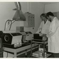
Pat Kelsey (left) and Rick Hootman using the Atomic Absorption Spectrophotometer to test for heavy metal and salt contaminants in the lab (3.4518)
Date: 1980sCreator: Kohout, John
Type: Photographic image
Description:Pat Kelsey (left) and Rick Hootman using the Atomic Absorption Spectrophotometer to test for heavy metal and salt contaminants in the lab
Extent: 1 photograph
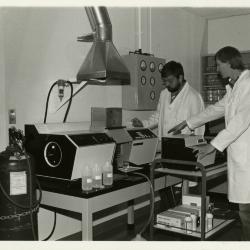
Pat Kelsey (left) and Rick Hootman using the Atomic Absorption Spectrophotometer to test for heavy metal and salt contaminants in the lab (3.4519)
Date: 1980sCreator: Kohout, John
Type: Photographic image
Description:Pat Kelsey (left) and Rick Hootman using the Atomic Absorption Spectrophotometer to test for heavy metal and salt contaminants in the lab
Extent: 1 photograph
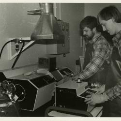
Soil scientists, Pat Kelsey (left) and Rick Hootman, at work in lab (3.4523)
Date: 1980sType: Photographic image
Description:Soil scientists, Pat Kelsey (left) and Rick Hootman, at work in lab
Extent: 1 photograph
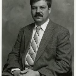
Pat Kelsey, seated portrait (3.5026)
Date: 1989Type: Photographic image
Description:Pat Kelsey, seated portrait
Extent: 1 photograph
South Farm Land Use [and topographic survey] (3.5273)
Date: February 13 1989Creator: Kelsey, Pat
Type: Map
Description:First issued Dec.30,1988 showing the South Farm area and building layout; the collection lacks this issuance. Collection has issuance dated Feb.13,1989 on which true elevation points determined upon by Richard G. Hootman have been added. A subsequent copy of the map (3.5275) showing additions dated February 14, 1989 and March 3, 1989 is also represented in the collections. Contour lines linking elevation points and benchmark indicators were added by P.D.Kelsey under date of Feb. 14 and a subsurface drainage installation was added by R.G.Hootman under date of March 3.
Extent: 1 sheet
South Farm Land Use [and topographic survey] (3.5275)
Date: February 14 – March 3 1989Creator: Kelsey, Pat
Type: Map
Description:First issued Dec.30,1988 showing the South Farm area and building layout; the collection lacks this issuance. Collection has issuance dated Feb.13,1989 on which true elevation points determined upon by Richard G. Hootman have been added. This copy of the map also shows additions dated February 14, 1989 and March 3, 1989 is also represented in the collections. Contour lines linking elevation points and benchmark indicators were added by P.D.Kelsey under date of Feb. 14 and a subsurface drainage installation was added by R.G.Hootman under date of March 3.
Extent: 1 sheet
South Farm Watershed Map (3.5577)
Date: February 15 1989Creator: Kelsey, Pat
Type: Map
Description:The watershed is traced on parts of sheets 1 and 2 of the Sidwell Company's Topographic survey of the Arboretum made in 1986 (SURV:A III (c) 2).
Extent: 1 sheet
Cross-sections and Elevations of the Cactus Pit [preliminary to development of the Endangered Species Habitat] (3.6102)
Date: July 17 1989Creator: Hootman, Rick
Type: Map
Extent: 1 sheet
Topographic Map of Willoway Creek Area Along Schulenberg Prairie by K.A. Altvatter, Richard G. Hootman, and Patrick D. Kelsey [preliminary] (3.6104)
Date: 1989Creator: Allen, Kimberly
Type: Map
Description:# 810 (3.6038) is stamped PRELIMINARY, but it is a duplicate of copy 1, # 876 (3.6104) which is not marked as preliminary. Recorded # 810 as a duplicate in this record.
Extent: 1 sheet
Topographic Map of Willoway Creek Area Along Schulenberg Prairie by K.A. Altvatter, Richard G. Hootman, and Patrick D. Kelsey (3.6105)
Date: 1989Creator: Allen, Kimberly
Type: Map
Description:Individual location elevations.
Extent: 1 sheet
Topographic Map of Willoway Creek Area Along Schulenberg Prairie by K.A. Altvatter, Richard G. Hootman, and Patrick D. Kelsey [ink on mylar] (3.6106)
Date: 1989Creator: Allen, Kimberly
Type: Map
Description:Copy 3 is an ink on mylar topographic map 220 cm x 92 cm (scale is 1 inch = 20 feet).
Extent: 1 sheet