Plat of Survey Showing the Location of Certain Buildings Under Construction on The Morton Arboretum Property in Lisle, Illinois (3.33786)
Date: December 7 1989Creator: Steinbrecher Jr., Harold F.
Type: Map
Extent: 1 sheet
Plat of Survey Morton Arboretum Agreement Line (3.35378)
Date: February 11 1992Creator: Roake & Associates, Inc.
Type: Map
Extent: 1 sheet
View from burial plot looking toward Lisle (3.37816)
Date: 1930Type: Photographic image
Description:View from burial plot looking toward Lisle
Extent: 1 negative

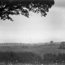
View from burial plot toward Lisle with tree on right (3.37817)
Date: 1930 – 1949Type: Photographic image
Description:View from burial plot toward Lisle with tree on right
Extent: 1 negative
Lisle, Illinois and vicinity, the Arboretum village; population 3,915, Sept., 1959. Compiled by [the] Directory Committee, First Congregational Church, Lisle, Illinois; drawn by Gordon G. Frey. (3.5900)
Date: January 1960Creator: First Congregational Church
Type: Map
Extent: 1 sheet
Lisle, Illinois and vicinity, the Arboretum village; population 8,400. [Revised] (3.5901)
Date: December 19 1975Creator: First Congregational Church
Type: Map
Extent: 1 sheet
Village of Lisle, Tollway Drainage Study [Revised] (3.6327)
Date: July 31 1981Creator: Lindley & Sons, Inc.
Type: Map
Description:C.2 lacks sheet one. Revised 1981-07-31. Additional changed marked in red.
Extent: 3 sheets, stapled
A Landscape Development Plan for the Community Center of the Lisle Park District (3.6457)
Date: March 1983Creator: Tyznik, Anthony
Type: Plan
Extent: 1 sheet
Plat of Survey and Topographic Map [of Arboretum land south of East-West Tollway] [no topographics] (3.6754)
Date: March 25 1970Creator: Steinbrecher, Harold F.
Type: Map
Description:Plan shown in survey was annexed to the City of Lisle in 1972.
This map doesn't show topographics. See related objects for a link to the map with topographics.
Extent: 1 sheet