Browsing by Subject/Keyword: decade:
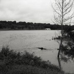
Dr. Malacek's land south of Arboretum during flood (3.33538)
Date: 1960sType: Photographic image
Description:Dr. Malacek's land south of Arboretum during flood
Extent: 1 negative filmstrip
An atlas of northeastern Illinois (3.5924)
Date: February 1969Creator: Northeast Illinois Planning Commission
Type: Map
Description:"Using a base of the United States Geological Survey flood hazard map quadrangles." Volume contains only quadrangles of the following areas: Elmhurst (HA-68), Hinsdale (HA-86), Lombard (HA-143), Romeoville (HA-146), Sag Bridge (HA-149), Naperville (HA-154), Wheaton (HA-148), West Chicago (HA-202), and Normantown (HA-210).
Extent: 1 volume (loose-leaf)
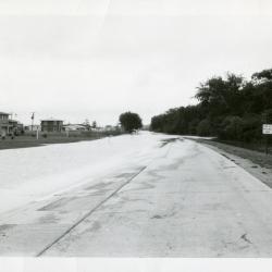
Route 53 north of Park Blvd in flood (3.60071)
Date: 1956 – 1960Type: Photographic image
Description:Route 53 north of Park Blvd in flood
Extent: 1 photograph
Floods in Wheaton, Illinois Quadrangle, northeastern Illinois (3.6815)
Date: 1965Creator: May, V. Jeff, Allen, Howard E.
Type: Map
Description:Map shows flooded areas 1954-63. Includes five figures profiling creek floods.
Extent: 1 sheet