Browsing by Subject/Keyword: decade:

General Information and Guide Map of The Morton Arboretum (3.34267)
Date: 1941Type: Map
Description:Doublesided brochure with general information and a guide map of The Morton Arboretum.
Guide map details Arboretum roads, trails, parking, plant collections, buildings and points of interest. Fifteen areas on the grounds highlighted in the key and identified with circled numbers on the map. Surfaced roads, gravel roads, and paths distinguished on the map by the type of line drawn. Compass showing directions north, south, east, west as well as scale indicator above top center of map.
Reverse side provides general information about the Arboretum, rules and regulations, and information about the Arboretum publication, Bulletin of Popular Information.
Extent: 1 sheet
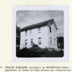
Charles Schroeder residence on Butterfield Road, taken for appraisal of farms at time estate was transferred (3.38238)
Date: 1940sType: Photographic image
Description:Charles Schroeder residence on Butterfield Road, taken for appraisal of farms at time estate was transferred
Extent: 1 photograph
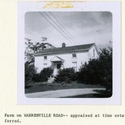
Farm on Warrenville Road, appraised at time estate was transferred (3.38239)
Date: 1940sType: Photographic image
Description:Farm on Warrenville Road, appraised at time estate was transferred
Extent: 1 photograph
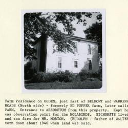
Farm residence on Ogden, formerly Ed Puffer farm, later called Arbor Farm (3.38240)
Date: 1940sType: Photographic image
Description:Farm residence on Ogden, just east of Belmont and Warrenville Roads (north side), formerly Ed Puffer farm, later called Arbor Farm. Entrance to Arboretum from this property. Kept hogs. Pond was observation point for the Holabirds. Eickhorsts lived there and ran farm for Mr. Morton. (Rudolph Eickhorst, father of Walter Eickhorst). House torn down about 1946 when land was sold.
Extent: 1 photograph
Map Showing the Morton Arboretum and the Adjoining Lands Owned by the Joy Morton Estate in DuPage County, Illinois, Compiled from Surveys and Deed Records (3.5347)
Date: September 1 1940Creator: Steinbrecher, Harold F.
Type: Map
Description:Map shows ms. annotations by C.E. Godshalk giving acreages as of March 21, 1965 and notes on purchases and sales of some land areas. A portion of the estate lies outside of the Arboretum boundaries. Collection has one copy showing various woodlands and buildings in colored shading added by Godshalk in the late 1950's; the Commonwealth Edison and Tollway rights-of-way are indicated.
Extent: 1 sheet
Map Showing the Morton Arboretum and the Adjoining Lands Owned by the Joy Morton Estate in DuPage County, Illinois, Compiled from Surveys and Deed Records (3.5348)
Date: September 1 1940Creator: Steinbrecher, Harold F.
Type: Map
Description:Map shows ms. annotations by C.E. Godshalk giving acreages as of March 21, 1965 and notes on purchases and sales of some land areas. A portion of the estate lies outside of the Arboretum boundaries. Collection has one copy showing various woodlands and buildings in colored shading added by Godshalk in the late 1950's; the Commonwealth Edison and Tollway rights-of-way are indicated.
Extent: 1 sheet
Map Showing the Morton Arboretum and the Adjoining Lands Owned by the Joy Morton Estate in DuPage County, Illinois, Compiled from Surveys and Deed Records (3.5707)
Date: September 1 1940Creator: Steinbrecher, Harold F.
Type: Map
Description:This copy shows various woodlands and buildings in colored shading added by Godshalk in the late 1950s. Collection includes maps showing ms. annotations by C.E. Godshalk giving acreages as of March 21, 1965 and notes on purchases and sales of some land areas.
The Commonwealth Edison and Tollway rights-of-way are indicated. A portion of the estate lies outside of the Arboretum boundaries.
Extent: 1 sheet
Map Showing the Morton Arboretum and the Adjoining Lands Owned by the Joy Morton Estate in DuPage County, Illinois, [Compiled from Surveys and Deed Records] (3.6676)
Date: September 1 1940Creator: Steinbrecher, Harold F.
Type: Map
Description:A portion of the estate lies outside of the Arboretum boundaries. Collection has one copy showing various woodlands and buildings in colored shading added by Godshalk in the late 1950s (Acc. # 478; 3.5707); the Commonwealth Edison and Tollway rights-of-way are indicated.
Extent: 1 sheet