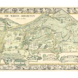
Morton Arboretum Map (3.19479)
Date: 1943Creator: Watts, May Theilgaard
Type: Map
Description:2014 reprint of The Morton Arboretum's first color map, circa 1943.
Detailed map of Arboretum grounds, showing roads, paths, landscaping, shelters, structures, enlargement of some specific features, hedge garden, some specific trees, and trails with markers numbered 1 - 42. Other features include a scale, a calendar, and a compass rose consisting of directions depicted with leaves. A highly ornamental border includes grid marks, as well as drawings of animal tracks and detailed drawings and labels of plants. The Morton Arboretum encompassed 813 acres at time of map.
Extent: 1 sheet

Thornhill Conference Center north entrance and walkway through spruce trees, soon after completion (3.36386)
Date: 1940sType: Photographic image
Description:Thornhill Conference Center north entrance and walkway through spruce trees, soon after completion
Extent: 1 negative

May T. Watts and class at the Arboretum, luncheon (3.33927)
Type: Photographic image
Description:May T. Watts and Helen Turner attend a luncheon at The Morton Arboretum Outpost with a large brick fireplace.
Extent: 1 photograph

Administration Building, front entrance and drive (3.3768)
Date: 1940sCreator: Mackay, Edward J.
Type: Photographic image
Description:Administration Building, front entrance and drive
Administration Building designed by Holabird & Root of Chicago, shown with parking court in front where lily pond later added.
Extent: 1 photograph
Walking Trails of The Morton Arboretum [base map for entire Arboretum] (3.5808)
Date: 1977Creator: Coulter, Ronald M.
Type: Map
Description:Base map presumably used in the preparation of the final version showing entire Arboretum. Written note on duplicate for this base map: Arboretum Trail and Road Map Collections Base Map
Extent: 1 sheet
Walking Trails of The Morton Arboretum [base map for East Side] (3.5807)
Date: 1977Creator: Coulter, Ronald M.
Type: Map
Description:Base map presumably used in the preparation of the final version showing eastern portion of the Arboretum. Note written on map: "Enlargement - Arb. Trail and Road Map - E. Side Collections Base Map
Extent: 1 sheet
Walking Trails of The Morton Arboretum [base map with trails and landmarks identified] (3.5801)
Date: 1977Creator: Coulter, Ronald M.
Type: Map
Description:Base map with landmarks, trails, parking, collections, etc. identified on map. Additional clear plastic overlay outlines various trails and possible new trails with red and green marker.
Extent: 2 sheets
Walking Trails of The Morton Arboretum [negative of Visitor Center area] (3.5804)
Date: 1976Creator: Coulter, Ronald M.
Type: Photographic image
Description:Photographic negative of Visitor Center area from base map presumably used in the preparation of the final version.
Extent: 1 sheet
[New Administration Entry, Color Garden and Pinetum Allée] (3.47517)
Creator: Walker, Catherine
Type: Plan
Description:Hardscape and lighting details with handwritten notes and adjustments. Sheets include:
West End: New Administration Entry
The Color Garden: Lower Terrace
The Color Garden: Center Terrace with Brimming Pool
The Color Garden: Upper Terrace
East End: Entrance to Pinetum Allée
East End: Entrance to Pinetum Allée
The Pinetum Allée: Four Columns to Seat Wall
The Color Garden: Lower Terrace
The Color Garden: Center Terrace with Brimming Pool
The Color Garden: Upper Terrace
East End: Entrance to Pinetum Allée
East End: Entrance to Pinetum Allée
The Pinetum Allée: Four Columns to Seat Wall
Extent: 7 Sheets
Equipment Storage Building Utility Plan (3.47513)
Date: June 17 2002Creator: Christopher B. Burke, Engineering West, Ltd.
Type: Plan
Description:Utility plan with handwritten notes and revisions.
"Project No. 00-927E"
Extent: 1 Sheet
Site Improvement Plans for Equipment Storage Building Title Sheet (3.47512)
Date: May 22 2002Creator: Christopher B. Burke, Engineering West, Ltd.
Type: Plan
Description:Title sheet for improvement plans with handwritten notes and revisions.
"Project No. 00-927E"
Extent: 1 Sheet
Site Improvement Plans for Equipment Storage Building (3.47511)
Date: February 13 2003Creator: Christopher B. Burke, Engineering West, Ltd.
Type: Plan
Description:"Project No. 00-927E"
Index:
Title Sheet
Existing Conditions
Geometric Plan
Grading & Drainage Plan
Utility Plan
Details
Specifications
Existing water atlas map (by Roake & Associates) provided for reference.
Extent: 9 Sheets
New Equipment Storage Facility (3.47480)
Date: May 15 2002Creator: Daniel W. Delimata Architects, Inc., Integrated Building Systems, Inc.
Type: Plan
Description:Building plans for an equipment storage facility in 2002.
Table of Contents:
T1 Title Sheet
A1 Elevations
A2 Floor Plan, Door Details
A3 Details
ME1 Mechanical and Electrical Plan
S1 Foundation Plan, Foundation Details
S2 Foundation Details, Saw Cut Plan
P1 Plumbing
F1 Preliminary Sprinkler Plans
"Original Submittal"
Extent: 9 Sheets
New Equipment Storage Facility (3.47477)
Date: May 15 2002Creator: Integrated Building Systems, Inc. , Daniel W. Delimata Architects, Inc.
Type: Plan
Description:Technical drawing and plans showing locations of FACP Control Panel, Pull Station, Audio/Visual. Includes floor plan and door jam details.
Extent: 1 Sheet
Southfarm Proposed Women's Locker Room (3.47254)
Date: December 17 2003Creator: Pelkonen, Peggy
Type: Plan
Description:Aerial survey indicating the location of a trailer with an elevation benchmark.
"Boring Location Plan"
Extent: 1 Sheet
Arbordale Utility Infrastructure Study, Exhibit 6, Proposed Utility Systems (3.47247)
Creator: Patrick Engineering, Inc.
Type: Plan
Description:Plans showing building structure, existing, and proposed utility lines, including water, sanitary, electric, gas, storm, and telecom.
Extent: 1 Sheet
Children's Garden Support Building Fire Alarm Electrical Plan (3.47227)
Date: February 2004Creator: David Woodhouse Architects
Type: Plan
Description:Electrical plan of the fire alarm system in the Children's Garden Support Building in 2004. Color coding highlights have been added.
Extent: 1 sheet
Sterling Pond Dam Reconstruction: New Dam Layout and Grading Plan (3.47220)
Date: April 2002Creator: Montgomery Watson Harza (MWH)
Type: Plan
Description:Plan of new dam layout with topographic map of Sterling Pond area.
Topographic map provided by Christopher B.Burke Engineering, LTD. (2002).
Extent: 1 Sheet
Sterling Pond Dam Reconstruction: Alternative New Dam Layout and Grading Plan (3.47219)
Date: April 2002Creator: Montgomery Watson Harza (MWH)
Type: Plan
Description:Plan of new dam layout with topographic map of Sterling Pond area.
Topographic map provided by Christopher B.Burke Engineering, LTD. (2002).
Handwritten numbers and equations.
Extent: 1 Sheet
Sterling Pond Dam Reconstruction: Alternative New Dam Layout and Grading Plan (3.47218)
Date: July 2002Creator: Montgomery Watson Harza (MWH)
Type: Plan
Description:Plan of new dam layout with topographic map of Sterling Pond area.
Topographic map provided by Christopher B.Burke Engineering, LTD. (2002)
Extent: 1 Sheet
Bur Reed Marsh Boardwalk Site Plan (3.44615)
Date: January 17 2000Creator: Christopher B. Burke, Engineering West, Ltd.
Type: Plan
Description:Sheet 1: Topographical survey of area and plan of the Bur Reed Marsh boardwalk with small insert map of the Woody Plant Collections indicating the project site.
Sheet 2: Bur Reed Marsh boardwalk design plan.
Extent: 2 sheets
New Maintenance Building for The Morton Arboretum (3.44612)
Creator: Daniel W. Delimata Architects, Inc.
Type: Plan
Description:Plumbing Plan
Waste Piping Diagram
Water Piping Diagram
Includes note: "This work not in original contract"
Extent: 1 Sheet
Equipment Storage Building (3.44611)
Creator: Cybor Fire Protection Company
Type: Plan
Description:Sprinkler installation plan for Equipment Storage Building.
Includes: Plan View at Roof, Site Plan, Section A-A, Riser Detail, Riser Material, General Notes
Extent: 1 Sheet
Equipment Storage Building Geometric Plan (3.44610)
Date: May 7 2002Creator: Christopher B. Burke, Engineering West, Ltd.
Type: Plan
Description:Topographical survey and plan for an equipment storage building.
Extent: 1 sheet
Arbor Court Electrical Plan (3.40161)
Date: November 15 2002Creator: Hitchcock Design Group
Type: Plan
Description:90% Review Set (Not for Construction)
Extent: 1 sheet
West End: New Administration Entry (3.40152)
Date: June 14 1999Creator: Walker, Catherine
Type: Plan
Description:Hardscape and lighting details.
Extent: 1 sheet
[The Color Garden and Pinetum Allée] (3.40123)
Date: June 14 1999Creator: Walker, Catherine
Type: Plan
Description:Hardscape and lighting details for The Color Garden and the Pinetum Allée. Sheets include:
The Color Garden: Lower Terrace
The Color Garden: Center Terrace with Brimming Pool
The Color Garden: Upper Terrace
East End: Entrance to Pinetum Allée
The Pinetum Allée: Four Columns to Seat Wall
The Color Garden: Center Terrace with Brimming Pool
The Color Garden: Upper Terrace
East End: Entrance to Pinetum Allée
The Pinetum Allée: Four Columns to Seat Wall
Extent: 5 sheets
West End: New Administration Entry (3.40122)
Date: June 14 1999Creator: Walker, Catherine
Type: Plan
Description:A mylar plan that has handwritten notes and a drawing directly on it.
Extent: 1 sheet
West End: New Administration Entry (3.40116)
Date: June 14 1999Creator: Walker, Catherine
Type: Plan
Description:A plan of the New Administration Entry with notes and cost estimates written on the document.
Extent: 1 sheet
Site Improvement Plans for Prairie Visitor Station (3.40115)
Date: March 11 2002Creator: Christopher B. Burke, Engineering West, Ltd.
Type: Plan
Description:A nine page series of plans/plat surveys that provide detailed information on the planning of the Prairie Visitor Station. Eight pages are stapled together in a binder. The final sheet (A-3) has been removed and is loose.
The Table of Contents on the Title Sheet lists sheet C-2 (Site Plan), but this sheet is not included in this binder.
Extent: 8 sheets in binder, 1 loose sheet
Prairie Visitor Station: Landscape Plan (3.40106)
Creator: Pelkonen, Peggy
Type: Plan
Description:A landscape plan that plots out plants and seeds planted near the Prairie Visitor Station.
Extent: 1 sheet
Prairie Visitor Station Concept Plan (3.40105)
Date: July 12 2000Creator: Mehaffey, Scott A.
Type: Plan
Extent: 1 sheet
Perspective View of Proposed Prairie Visitor Station (3.39965)
Date: October 5 2001Type: Plan
Description:A colored drawing duplicated onto paper.
Extent: 1 sheet
Thornhill Educational Center: First and Second Floors (3.39962)
Date: 1992Creator: Bauer Latoza Studio
Type: Plan
Description:Two sheets of paper taped together showing the floor plans of the Thornhill Education Center's first and second floors.
Extent: 1 sheet