[Route 53, entry road, parking lot, Meadow Lake area landscape plan] (3.31967)
Type: Plan
Extent: 1 sheet
[Route 53, entry road, parking lot, Meadow Lake area landscape plan - colored version] (3.31968)
Type: Plan
Description:Areas highlighted in color pencil on landscape plan
Extent: 1 sheet
An Existing Landscape For IL Rte. 53 Between Sta. 966.00 And Sta. 980.00 (3.6541)
Creator: Tyznik, Anthony
Type: Plan
Extent: 1 sheet
[Meadow Lake Regrading Project] (3.32035)
Type: Plan
Description:Includes parking and road renovation; shows parts of Meadow Lake, parking lot, entry road, and Route 53.
Extent: 1 sheet
[Retaining wall project] (3.31984)
Type: Plan
Description:Shows south edge of The Morton Arboretum along I-88 east of Route 53.
Extent: 1 sheet
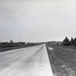
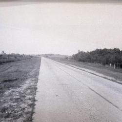
Route 53 when it was two lanes (3.33210)
Type: Photographic image
Description:Route 53 when it was two lanes
Extent: 1 negative
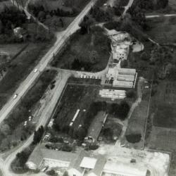
Aerial view of Administration Building, greenhouses, nursery, South Farm (3.38489)
Type: Photographic image
Description:Aerial view of Administration Building, greenhouses, nursery, South Farm
Extent: 1 filmstrip
[Proposed Foot/Bike Bridge and Ramp Across Route 53 North of Park Blvd.] (3.6490)
Creator: Tyznik, Anthony
Type: Plan
Description:Proposed idea for bike trail across Route 53 and Park Blvd. (highlighted in color pencil).
Extent: 1 sheet
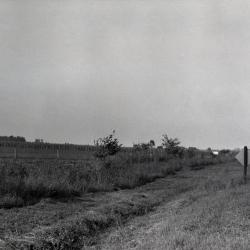
Route 53 when it was two lanes alongside open land (3.33211)
Type: Photographic image
Description:Route 53 when it was two lanes alongside open land
Extent: 1 negative
[Retaining Wall, I-88 Parapet Over Route 53] (3.32017)
Type: Plan
Description:One sheet with eight elevations of I-88 parapet over Route 53, with retaining wall, abutments, and wing walls.
Extent: 1 sheet
[Administration Building, Research Wing, and Greenhouses] (3.6808)
Type: Plan
Description:Map includes South Farm buildings, Route 53, service drive and "public parking" south of service drive.
Extent: 1 sheet
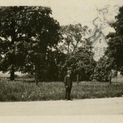
Future site of Clarence Godshalk's first Arboretum house (sketched in behind trees), Emil in foreground (3.38221)
Date: 1920sType: Photographic image
Description:Future site of Clarence Godshalk's first Arboretum house (sketched in behind trees), Emil in foreground
Extent: 1 photograph
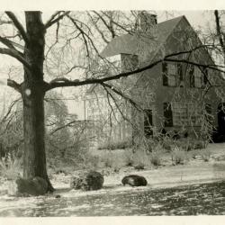
Clarence Godshalk's first Arboretum house, exterior side view of front from frozen Joliet Road, winter (3.38222)
Date: 1920sType: Photographic image
Description:Clarence Godshalk's first Arboretum house, exterior side view of front from frozen Joliet Road, winter
Extent: 1 photograph
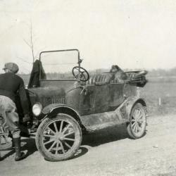
Clarence E. Godshalk and his dog, Punch, with Joy Morton's castoff Model T car (3.3531)
Date: 1920sType: Photographic image
Description:Clarence E. Godshalk and his dog, Punch, with Joy Morton's castoff Model T car
Photograph taken in front of Tony's house on Route 53, looking toward Lake Marmo
Extent: 1 photograph
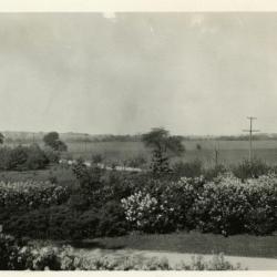
Lilacs, entrance, and highway (now Route 53) viewed from upstairs window of Clarence Godshalk's first Arboretum house, looking northeast (3.38216)
Date: 1920sType: Photographic image
Description:Lilacs, entrance, and highway (now Route 53) viewed from upstairs window of Clarence Godshalk's first Arboretum house, looking northeast
Extent: 1 photopgraph
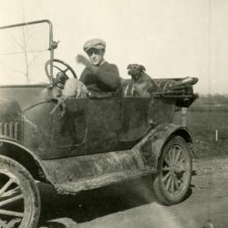
Clarence E. Godshalk and his dog, Punch, inside Joy Morton's castoff Model T car (3.3794)
Date: 1920sType: Photographic image
Description:Clarence E. Godshalk and his dog, Punch, inside Joy Morton's castoff Model T car, on Route 53, looking toward Lake Marmo
Extent: 1 photograph
Topographical Plat of Portion of Land to be Used for Morton Arboretum, Lisle, Illinois (3.5237)
Date: July 1921Creator: O. C. Simonds & Co.
Type: Map
Description:Surveys topography east of Route 53. Locations are shown for eight species of existing woodland cover.
Extent: 1 sheet

View of unpaved Joliet Road (now IL Route 53) and land/woods in the distance from Clarence Godshalk's first Arboretum house and lawn (3.37826)
Date: 1922Type: Photographic image
Description:View of unpaved Joliet Road (now IL Route 53) and land/woods in the distance from Clarence Godshalk's first Arboretum house and lawn
Extent: 1 photograph
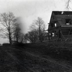
Arboretum entrance road (Joliet Road), showing Clarence Godshalk's first Arboretum house under construction along right side of road (3.36083)
Date: 1922Type: Photographic image
Description:Arboretum entrance road (Joliet Road), showing Clarence Godshalk's first Arboretum house under construction along right side of road
Extent: 1 negative
Plan for Rosaceae and Oleaceae shrub gardens: roses, spiraeas, lilacs, etc., Morton Arboretum (3.5641)
Date: 1922Creator: O. C. Simonds & Co.
Type: Plan
Description:Plants for the area bordering Joliet Road ( the present Route 53 ) in the central western portion of the Arboretum.
Extent: 1 sheet
Plan for Rosaceae and Oleaceae shrub gardens; roses, spiraeas, lilacs, etc., Morton Arboretum (3.5938)
Date: 1922Creator: O. C. Simonds & Co.
Type: Plan
Description:Plants for the area bordering Joliet Road (the present Route 53) in the central western portion of the Arboretum
Extent: 1 sheet
Morton Arboretum Section"A" [Part of the S 1/2 of the S 1/2 of Sec.34, T.39 N., R. 10 E, and such portion of Sec.35 … and part of the N 1/2 of Sec.3, T.38 N., R.10 E] (3.7204)
Date: December 9 1922Creator: Webster, Arthur L.
Type: Map
Description:The initial survey of the west portion of the Arboretum bordering Route 53 to the east and Thornhill Farm to the north, an area totaling 150.2 acres. A subsequent survey of an expanded Section "A" was carried out in 1934 by J. S. Lozier and Harold F. Steinbrecher; this was issued under the title: Revised plat of Section "A" (SURV:B III (d) 1).
Original. Includes general landscaping drawn in.
Extent: 1 sheet
Morton Arboretum Section "A" [Part of the S 1/2 of the S 1/2 of Section 34, T.39 N., R. 10 E, and such portion of Section 35 … and part of the N 1/2 of Section 3, T.38 N., R.10 E] (3.5296)
Date: December 9 1922Creator: Webster, Arthur L.
Type: Map
Description:The initial survey of the west portion of the Arboretum bordering Route 53 to the east and Thornhill Farm to the north, an area totaling 150.2 acres. A subsequent survey of an expanded Section "A" was carried out in 1934 by J. S. Lozier and Harold F. Steinbrecher; this was issued under the title: Revised plat of Section "A" (SURV:B III (d) 1).
Extent: 1 sheet
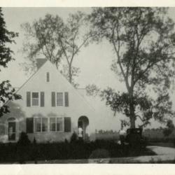
Clarence Godshalk's first Arboretum house, front exterior view, Harriet standing in doorway, Clarence at car (3.3824)
Date: August 1923Type: Photographic image
Description:Clarence Godshalk's first Arboretum house, front exterior view, Harriet standing in doorway, Clarence at car (Chevrolet)
Extent: 1 photograph

View from present Arboretum Center to Morton residence (3.37814)
Date: 1926Type: Photographic image
Description:View from present Arboretum Center (Administration Building) to Morton residence, looking west across Joliet Road (now Route 53)
Extent: 1 negative
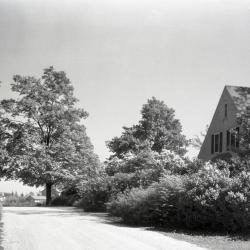
Arboretum west entrance road (Route 53/Joliet Road), Clarence Godshalk's first Arboretum house along right side of road (3.36092)
Date: 1930Type: Photographic image
Description:Arboretum west entrance road (Route 53/Joliet Road), Clarence Godshalk's first Arboretum house along right side of road
Extent: 1 negative
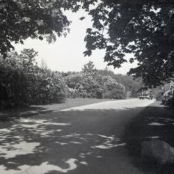
Car entering Arboretum west entrance at Route 53 (3.32121)
Date: 1930sType: Photographic image
Description:Car entering Arboretum west entrance at Route 53
*located at about 38-L on Arboretum map/grid
Extent: 1 negative
Route 53 when it was two lanes (3.32124)
Date: 1930sType: Photographic image
Description:Route 53 when it was two lanes
Extent: 1 negative
Car driving out of Arboretum west entrance toward Route 53 (3.32120)
Date: 1930sType: Photographic image
Description:Car driving out of Arboretum west entrance toward Route 53
*located at about 38-L on Arboretum map/grid
Extent: 1 negative
Morton Arboretum Section "B" (3.6005)
Date: January 22 1931Creator: Webster, Arthur L.
Type: Map
Description:Surveys the original area of Section "B" along the north boundary of the Arboretum extending eastward from Route 53.
Extent: 1 sheet
Morton Arboretum Section "B" (3.6145)
Date: June 6 1932Creator: Webster, Arthur L.
Type: Map
Description:Surveys the original area of Section "B" along the north boundary of the Arboretum extending eastward from Route 53. Includes parcels "Morton to Arboretum" and "Rogers to Morton" dated June 6, 1932.
Extent: 1 sheet
Assessment Plat No. 1, Lands Belonging to Trustees Under the Will of Joy Morton, Deceased, Lisle, Township, DuPage County, Illinois (3.5305)
Date: September 29 1934Creator: Lozier, J. S.
Type: Map
Description:Surveys a "U"-shaped area, 94.056 acres, that spans Route 53 and extends northward from Warrenville Road into the South Farm area. The major interchange of the East-West Tollway and Route 53 is located within the present day tract.
Extent: 1 sheet
Revised Plat of Section "A", Morton Arboretum (3.5998)
Date: September 29 1934Creator: Lozier, J. S.
Type: Map
Description:Surveys the area west of Route 53 and south of Thornhill, a tract totaling 201.83 acres. The revised plat supersedes an earlier survey by Arthur L. Webster made in 1922 (SURV:B II(b)1).
Includes ms notes by C.E. Godshalk on lands deeded to the Arboretum.
Extent: 1 sheet
Revised Plat of Section "A," Morton Arboretum (3.5321)
Date: September 29 1934Creator: Lozier, J. S.
Type: Map
Description:Surveys the area west of Route 53 and south of Thornhill, a tract totaling 201.83 acres. The revised plat supersedes an earlier survey by Arthur L. Webster made in 1922 (SURV:B II (b) 1).
Extent: 1 sheet
[Survey of Parts of Sections 34 and 35, Milton Township and Part of Section 3, Lisle Township, DuPage County, Illinois] (3.6368)
Date: September 29 1934Creator: Lozier, J. S.
Type: Map
Description:Portion of Arboretum west of Route 53. Pencil corrections and "Total 204.935 Acres," "3.799 Acres," "9.735 Acres," and "4120 Acres."
Extent: 1 sheet