Browsing by Subject/Keyword: decade:
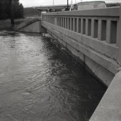
Old Route 53 two lane bridge over DuPage River (3.33537)
Date: 1960sType: Photographic image
Description:Old Route 53 two lane bridge over DuPage River
New highway bridge being built in background
Extent: 1 negative filmstrip

A Guide Map of The Morton Arboretum (3.34269)
Date: 1969Creator: Tyznik, Anthony
Type: Map
Description:A guide map of The Morton Arboretum created by Tony Tyznik in 1969. The background is a dark green with the inner Arboretum being a light green and Arboretum roads highlighted in solid orange and checkered orange lines.
Extent: 1 sheet
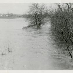
Route 53 in flood, north of Park Blvd (3.37483)
Date: 1959 – 1960Type: Photographic image
Description:Route 53 in flood, north of Park Blvd
Extent: 1 photograph
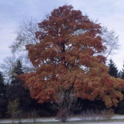
Acer saccharum (sugar maple), habit, fall (3.37971)
Date: September 1969Creator: Hall, Marion Trufant
Type: Photographic image
Description:Acer saccharum (sugar maple), full view of tree with golden-orange fall foliage situated next to a paved road west of Highway 53
Extent: 1 slide
Morton Arboretum map [proposed land use 1969] (3.5764)
Date: December 1969Creator: Hart, Nancy
Type: Plan
Description:Shows Arboretum structures and major connecting roads/trails from the Thornhill area to Meadow Lake and South Farm. An updated version of this map was done at a later date by Anthony Tyznik. Cover sheet states: 1969 Proposed Land Use Morton Arboretum.
Extent: 1 sheet attached to posterboard
Route 53 north of Park Blvd in flood (3.60071)
Date: 1956 – 1960Type: Photographic image
Description:Route 53 north of Park Blvd in flood
Extent: 1 photograph
Route 53 (3.7031)
Date: 1965Creator: Patterson, Rhodes
Type: Map
Description:Photos, Arboretum map, calendar for October, November, December. Design: Hayward Blake. Printer: Low's Incorporated.
Extent: 1 sheet