Making Ice at the Arboretum (in the Good old Days) (3.10823)
Date: December 21 1979 – March 20 1980Creator: Godshalk, Clarence E.
Type: Article
Woody Plant Collections at the Morton Arboretum: Content and Arrangement (3.10860)
Date: December 21 1981 – March 20 1982Creator: Schulenberg, Ray
Type: Article

Landscape Features of The Morton Arboretum (3.11007)
Date: September 21 – December 20 1990Creator: Hootman, Rick, Kelsey, Pat
Type: Article
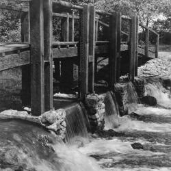
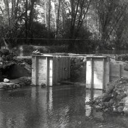
Bridge and dam across DuPage River (west branch) (3.2979)
Date: 1950sCreator: Miller, W. L.
Type: Photographic image
Description:Bridge and dam across DuPage River (west branch)
Bridge and dam with gates designed by Clarence Godshalk to control water level of Lake Jopamaca.
Replaced the artificial concrete & stone rapids built in 1930's. This bridge/gate taken out around 1980
Extent: 1 photograph
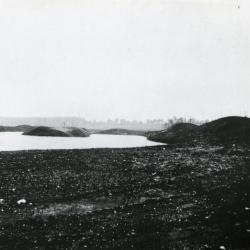
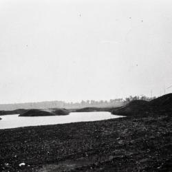
Lake Jopamaca Early Digging (3.3023)
Type: Photographic image
Description:Lake Jopamaca Early Digging
Extent: 1 photograph
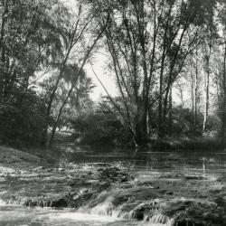
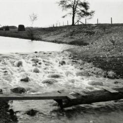
The Waterfall (3.3031)
Date: 1930sCreator: Hartshorn, Ken
Type: Photographic image
Description:The Waterfall - the rapids built in DuPage River to raise water level in Lake Jopamaca. These were made from concrete with stones set in while soft. Later replaced by dam with gates to control water level. Used to see large northern pike go up over the rapids in Spring
Extent: 1 photograph
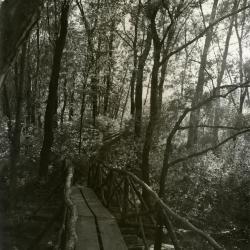
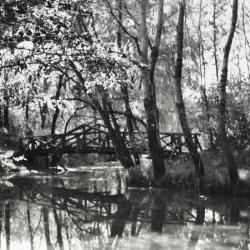
Footbridge over Lake Jopamaca leading into Ozarks Collection (3.3038)
Date: 1930sType: Photographic image
Description:Footbridge over Lake Jopamaca leading into Ozarks Collection
Extent: 1 photograph
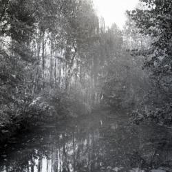
Looking southwest from bridge over DuPage River toward Lake Jopamaca (3.3040)
Date: October 1941Type: Photographic image
Description:Looking southwest from bridge over DuPage River toward Lake Jopamaca
Extent: 1 photograph
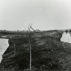
Ozarks first planting alongside nearly constructed Lake Jopamaca, DuPage River to the right (3.3070)
Date: March 21 – June 20 1922Type: Photographic image
Description:Looking north at Ozarks first planting alongside nearly constructed Lake Jopamaca, DuPage River to the right
Extent: 1 photograph
Lunching & Learning with Clarence Godshalk: Evolution of the Arboretum - From Farm to Arboretum (3.31582)
Date: January 25 1978Type: Audio
Description:Lunching and Learning program presented by Clarence Godshalk as he describes the evolution of the Arboretum, from farm land to Arboretum.
Extent: 1 audio cassette
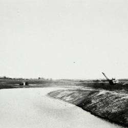
Lake Jopamaca in Ozarks after it was completed (3.33518)
Date: 1922Type: Photographic image
Description:Looking south over Lake Jopamaca in Ozarks soon after it was completed.
Lake dug by Yale and Regan with drag line. Grading done by Mr. Godshalk with men and mule teams.
Extent: 1 negative filmstrip
Lake Jopamaca in the Ozarks, dug by drag line (shown in background) (3.33531)
Date: 1922Type: Photographic image
Description:Lake Jopamaca in the Ozarks, dug by drag line (shown in background)
Extent: 1 negative filmstrip
Rapids built in DuPage River to raise water level in Lake Jopamaca (3.33532)
Date: 1922Type: Photographic image
Description:First rapids built in DuPage River to raise water level in Lake Jopamaca, made of sod, fence wire, etc. (the rapids did not last)
Extent: 1 negative filmstrip
Footbridge over inlet to Lake Jopamaca (3.33539)
Date: 1930sType: Photographic image
Description:First footbridge designed by Clarence Godshalk over inlet to Lake Jopamaca
Extent: 1 negative filmstrip
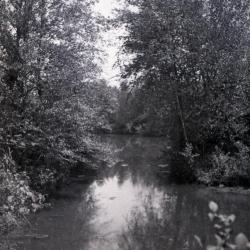
Walking path along Lake Jopamaca looking south (3.33543)
Type: Photographic image
Description:Walking path along Lake Jopamaca looking south
*located at about 30-S on Arboretum map/grid
Extent: 1 negative
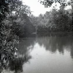
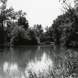
Lake Jopamaca looking north (3.33552)
Type: Photographic image
Description: Lake Jopamaca looking north
*located at about 27-O on Arboretum map/grid
Extent: 1 negative
Lake Jopamaca looking north (3.33553)
Type: Photographic image
Description:Lake Jopamaca looking north
*located at about 27-P on Arboretum map/grid
Extent: 1 negative
Lake Jopamaca looking north (3.33554)
Type: Photographic image
Description:Lake Jopamaca looking north
*located at about 27-P on Arboretum map/grid
Extent: 1 negative
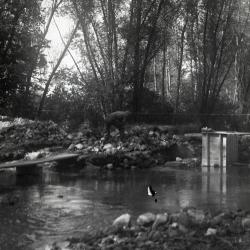
DuPage River dam, construction (3.33565)
Type: Photographic image
Description:Construction of DuPage River dam, with gates to control water level to Lake Jopamaca
Dam torn out in 1982
Extent: 1 negative
DuPage River dam (3.33567)
Date: 1940sType: Photographic image
Description:DuPage River dam with removable planks to slow water coming into Lake Jopamaca from the DuPage River and prevent silt buildup
Dam torn out in 1982
Extent: 1 negative
DuPage River dam, construction (3.33568)
Date: 1940sType: Photographic image
Description: Construction of DuPage River dam, with gates to control water level to Lake Jopamaca
Dam torn out in 1982
Extent: 1 negative
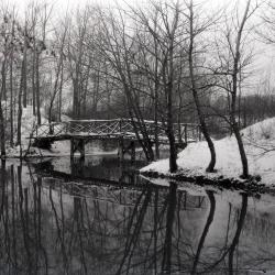
Jopamaca footbridge over DuPage River in winter (3.33981)
Type: Photographic image
Description:Jopamaca footbridge over DuPage River in winter
Extent: 1 negative
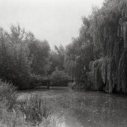
Lake Jopamaca and footbridge, looking east toward DuPage River (3.33982)
Date: 1930 – 1949Type: Photographic image
Description:Lake Jopamaca and footbridge, looking east toward DuPage River
Extent: 1 negative
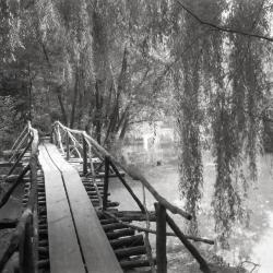
Lake Jopamaca footbridge, looking south (3.33984)
Date: 1930 – 1949Type: Photographic image
Description:Lake Jopamaca footbridge, looking south
Extent: 1 negative
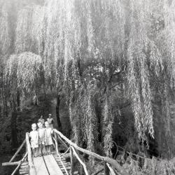
Three boys on Lake Jopamaca Footbridge (3.33985)
Date: 1930sType: Photographic image
Description:Three boys on Lake Jopamaca footbridge with two women in background
Extent: 1 negative
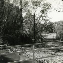
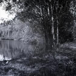
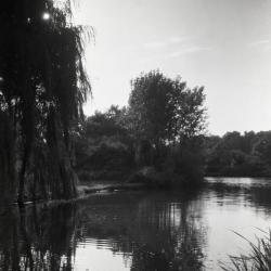
Lake Jopamaca vegetation along west side shoreline (3.34005)
Date: 1930 – 1949Type: Photographic image
Description:Lake Jopamaca vegetation along west side shoreline
Extent: 1 negative
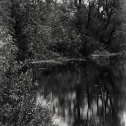
Lake Jopamaca in summer looking west (3.34006)
Date: 1930 – 1949Type: Photographic image
Description:Lake Jopamaca in summer looking west
Extent: 1 negative

Map & Visitor Guide, The Morton Arboretum (3.34271)
Date: 1982 – 1986Type: Map
Description:Double-sided brochure, Map & Visitor Guide for The Morton Arboretum
Map details Arboretum roads, trails, plant collections, buildings and boundaries. Includes photographs of various Arboretum buildings with descriptive information.
Reverse side provides general information about the Arboretum, trails for walking and hiking, driving through the Arboretum, areas and collections of special interest, native plant communities, wildlife at the Arboretum, regulations, facilities and services, and information on membership. A section of the map is enlarged to identify landmarks around the Visitor Center, Administration Building, and Thornhill Education Center.
Extent: 1 sheet
[Planting Plan for the Poplars and Birches in the Lake Jopamaca Area] (3.5687)
Date: 1920sCreator: Teuscher, Henry
Type: Plan
Description:Plan shows Joy Morton's signature of approval.
Extent: 1 sheet
Tony Byrne talking to Clarence Godshalk about a typical day at the Arboretum as Superintendent in 1922 (3.67330)
Type: Audio
Description:Tony Byrne interviewing Clarence Godshalk on what work he typically was involved in as The Morton Arboretum's superintendent in the 1920s.