Browsing by object type: century:
Mowing and Natural Areas Management (3.100236)
Date: June 8 2001Creator: Pelkonen, Peggy
Type: Map
Description:Map illustrates the schedule and means by which the grounds are maintained.
Extent: 1 sheet
Natural Area Management (3.100237)
Date: June 8 2001Creator: Pelkonen, Peggy
Type: Map
Description:Map illustrates the schedule and means by which the grounds are burn managed.
Extent: 1 sheet
Collections Master Plan, Collection Zones (3.100238)
Date: December 2000Type: Map
Description:A map of The Morton Arboretum divided into numbered sections which represent the Arboretum's collections.
Extent: 1 sheet
Site Plan, Planned Improvements (3.100239)
Date: May 15 2002Creator: Pelkonen, Peggy
Type: Map
Description:Map of The Morton Arboretum showing existing roads and structures, waterbodies and wetlands, trails, service access, road removals, proposed improvements, and proposed retention.
Extent: 1 sheet on foamcore
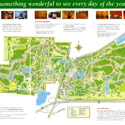
The Morton Arboretum Visitor Map Fall 2005 (3.106101)
Date: 2005Creator: Pulse Design, Inc.
Type: Map
Description:Double-sided brochure, Visitor Map and guide for The Morton Arboretum.
Map details Arboretum roads, trails, plant collections, buildings and boundaries. Includes more detailed maps of the areas around the Thornhill Education Center ad the Visitor Center. Text surrounding the maps lists West and East Side highlights and trails.
Reverse side provides general information about the Arboretum, seasonal highlights, programs, and events.
Extent: 1 sheet

Vegetation of the Chicago Region as Mapped by the Public Land Survey 1821-1845 (3.113833)
Date: 2014Creator: Halsey, Sam, McBride, Jenny
Type: Map
Description:A map created in 2006 portraying vegetation of the Chicago Region from 1821-1845.

Vegetation of the Northwest Indiana as Mapped by the Public Land Survey 1829-1835 (3.113834)
Date: 2015Creator: McBride, Jenny, Halsey, Sam
Type: Map
Description:A map created in 2006 portraying vegetation of Northwest Indiana from 1829-1835.

Vegetation of the Southwest Michigan as Mapped by the Public Land Survey 1828-1842 (3.113835)
Date: 2015Type: Map
Description:A map created in 2006 portraying vegetation of Southwest Michigan from 1828-1942.

Vegetation of the Southeast Wisconsin as mapped by the Public Land Survey 1833-1836 (3.113836)
Date: 2015Creator: Halsey, Sam
Type: Map
Description:A map created in 2006 portraying vegetation of Southeast Wisconsin from 1833-1836.

Vegetation of the Prairie Peninsula Region of Southern Lake Michigan as Mapped by the Public Land Survey 1829-1835 (3.113837)
Date: 2015Creator: Halsey, Sam, McBride, Jenny
Type: Map
Description:A map created in 2006 portraying vegetation of Prairie Peninsula Region of Southern Lake Michigan from 1829-1835.
Nature Connects Map (3.31593)
Date: 2015Type: Map
Description:A visitor map of the locations of all 13 LEGO sculptures of the Nature Connects: Art with LEGO Bricks by Sean Kenney exhibit.
Morton Arboretum Willoway Brook tributary stream enhancement project, phase II, DuPage County, Illinois (3.31598)
Date: March 28 2005Type: Map
Description:Thomas Burke, Jr.
Extent: 11 sheets bound
Children's Garden: Adventure Woods--Planting Overstory Plan A (3.35371)
Date: 2003Creator: Hitchcock Design Group
Type: Map
Extent: 1 sheet
Compensatory Storage Facility As-Built (3.44574)
Date: February 24 2004Creator: Christopher B. Burke, Engineering West, Ltd.
Type: Map
Description:Topographic map prepared for purpose of depicting existing grading on 9-17-2003.
Project number 00-927AA
Extent: 1 Sheet
Meadow Lake Improvements Vicinity Topographic Map (3.44576)
Date: December 2 2002Creator: Montgomery Watson Harza (MWH)
Type: Map
Description:
Extent: 1 sheet
Main Entrance/Main Road, Phase 2, Overall Plan (3.44577)
Date: November 21 2002Creator: Christopher B. Burke, Engineering West, Ltd.
Type: Map
Description:Includes planting plans for East Branch, DuPage River Detention Facility and Compensatory/Wetland Mitigation Storage Facility. Includes Planting Specifications.
Extent: 5 Sheets
Equipment Storage Building Existing Conditions (3.44613)
Date: May 22 2002Creator: Christopher B. Burke, Engineering West, Ltd.
Type: Map
Description:Project No. 00-927E
Extent: 1 Sheet
As-Built Survey [Meadow Lake] Prepared for Doestch Brothers Excavating Company [June 2005] (3.47223)
Date: June 22 2005Type: Map
Description:Topographical survey of Meadow Lake
"Project No. 04-412"
This survey is based on field work performed on 12-10-2003 and 07-13-2004 through 07-26-2004.
Surveyor's certificate dated June 22, 2005.
Extent: 1 Sheet
As-Built Survey [Meadow Lake] Prepared for Doestch Brothers Excavating Company [March 2005] (3.47224)
Date: March 8 2005Type: Map
Description:Topographical survey of Meadow Lake
"Project No. 04-412"
This survey is based on field work performed on 12-10-2003 and 07-13-2004 through 07-26-2004.
Surveyor's Certificate dated March 8, 2005.
Extent: 1 Sheet
Aerial Image of Arboretum Grounds (3.47230)
Date: December 2007Creator: Pelkonen, Peggy
Type: Map
Description:Aerial image of Arboretum grounds in 2007 with handwritten notes and circled regions showing detention basins.
Black and white with some color.
Extent: 1 Sheet
Record Grading Map of Arbordale Plant Production Facility - Detention Basin Modifications (3.47232)
Date: August 20 2004Creator: V3 Consultants, Inc.
Type: Map
Description:Record grading map with topographical survey of the Arbordale Plant Production Facility Detention Basin.
"Project No. 03081"
"Group No. V09"
Extent: 1 sheet
East Branch Detention As-Built [handwritten notes] (3.47233)
Date: February 24 2004Creator: Christopher B. Burke, Engineering West, Ltd.
Type: Map
Description:Topographical Map of the East Branch Detention Basin in 2004 with handwritten notes and adjustments.
"Project No. 00-927AA"
Handwritten note: "See "Arbordale Plant Production Facility Detention Basin Modifications" As-Built for weir & Control Structure As-Built"
Extent: 1 Sheet
East Branch Detention As-Built (3.47234)
Date: February 24 2004Creator: Christopher B. Burke, Engineering West, Ltd.
Type: Map
Description:Topographical Map of the East Branch Detention Basin in 2004.
"Project No. 00-927AA"
As-Built Compensatory Storage/ Wetland Mitigation Area (3.47235)
Date: October 14 2005Type: Map
Description:Topographic map depicting landscaped areas, floodplains, edge of flagged wetlands, pipe culvert locations.
"Project No. 00-927AA"
Extent: 1 Sheet
Plat of Survey of the Morton Arboretum (3.47242)
Date: June 30 2000Creator: Roake & Associates, Inc.
Type: Map
Description:"Being parts of sections 33, 34, 35 and 36, Township 39 North range 10 East, and parts of sections 1, 2, 3, and 4, Township 38 North range 10 East of the third principal meridian in DuPage County, IL"
Hand-drawn circled area with handwritten note "Project site" on first page.
Extent: 2 Sheets
Concept Park Boulevard Entrance (3.47501)
Date: January 9 2001Creator: Christopher B. Burke, Engineering West, Ltd.
Type: Map
Description:Color aerial map showing existing entrance and exit to be removed and proposed entrance, exit, and parking facility in 2001.
"Project No. 00-910"
Extent: 1 Sheet
Plat of Survey of the Morton Arboretum (3.47506)
Date: June 30 2000Type: Map
Description:"Being parts of sections 33, 34, 35 and 36, Township 39 North range 10 East, and parts of sections 1, 2, 3, and 4, Township 38 North range 10 East of the third principal meridian in DuPage County, IL"
Hand-drawn circled area with handwritten note "Project site" on first page.
Extent: 2 Sheets
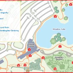
[Topographic Survey of Visitor Center, Arbor Court, Maze Garden, and Children's Garden] (3.47509)
Date: October 29 2002Creator: Hitchcock Design Group
Type: Map
Description:Topographic survey and map of the Visitor Center, Arbor Court, Maze Garden, and Children's Garden.
Scale, date, and HDG written in marker in lower right corner.
Extent: 1 Sheet

Vegetation of the Chicago Region as Mapped by the Public Land Survey 1821-1845 (3.56016)
Date: 2006Creator: McBride, Jenny
Type: Map
Description:A map created in 2006 portraying vegetation of the Chicago Region from 1821-1845.
Morton Arboretum plant evaluation area (3.6768)
Date: January 24 2000Creator: Halloran & Yauch, Inc.
Type: Map
Description:"Godshalk Meadow" Inset "site map (1" = 600') shows location west of Route 53 entrance. "As-Built"
Extent: 1 sheet
Morton Arboretum west side entrance Rt. 53 Lisle (3.6821)
Date: January 24 2000Creator: Halloran & Yauch, Inc.
Type: Map
Description:Inset drawing: "Quick coupling valve installation". "As-Built"
Extent: 1 sheet
Morton Arboretum Administration & east side 53 entrance (3.6823)
Date: January 24 2000Creator: Halloran & Yauch, Inc.
Type: Map
Description:"As-Built"
Extent: 1 sheet
Morton Arboretum plant evaluation area (3.6824)
Date: January 24 2000Creator: Halloran & Yauch, Inc.
Type: Map
Description:"Godshalk Meadow" Inset "site map (1" = 600') shows location west of Route 53 entrance. "As-Built"
Extent: 1 sheet
Sanitary/Sewer plan & profile - 3 South 555 Leask Lane, Lisle, IL 60137 (3.7020)
Date: July 21 2000Creator: Harding Lawson Associates
Type: Map
Extent: 1 sheet
Water service connection, The Morton Arboretum, 3 South 555 Leask Lane, Lisle, IL (3.7023)
Date: September 28 2000Creator: Harding Lawson Associates
Type: Map
Description:Pencil revision
Extent: 3 sheets stapled
Water service connection, The Morton Arboretum, 3 South 555 Leask Lane, Lisle, IL (3.7025)
Date: September 28 2000Creator: Harding Lawson Associates
Type: Map
Description:Pencil revisions and color printed highlights.
Extent: 3 sheets stapled