Browsing by object type: decade:
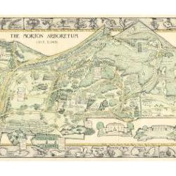
Morton Arboretum Map (3.19479)
Date: 1943Creator: Watts, May Theilgaard
Type: Map
Description:2014 reprint of The Morton Arboretum's first color map, circa 1943.
Detailed map of Arboretum grounds, showing roads, paths, landscaping, shelters, structures, enlargement of some specific features, hedge garden, some specific trees, and trails with markers numbered 1 - 42. Other features include a scale, a calendar, and a compass rose consisting of directions depicted with leaves. A highly ornamental border includes grid marks, as well as drawings of animal tracks and detailed drawings and labels of plants. The Morton Arboretum encompassed 813 acres at time of map.
Extent: 1 sheet

Morton Arboretum Map (3.19481)
Date: 1943Creator: Watts, May Theilgaard
Type: Map
Description:Detailed map of Arboretum grounds, showing roads, paths, landscaping, shelters, structures, enlargement of some specific features, hedge garden, some specific trees, and trails with markers numbered 1 - 42. Other features include a scale, a calendar, and a compass rose consisting of directions depicted with leaves. A highly ornamental border includes grid marks, as well as drawings of animal tracks and detailed drawings and labels of plants. Some replacement illustration and text has been adhered to the map. The Morton Arboretum encompassed 813 acres at time of map. One section is partially missing.
Extent: 1 sheet

General Information and Guide Map of The Morton Arboretum (3.34267)
Date: 1941Type: Map
Description:Doublesided brochure with general information and a guide map of The Morton Arboretum.
Guide map details Arboretum roads, trails, parking, plant collections, buildings and points of interest. Fifteen areas on the grounds highlighted in the key and identified with circled numbers on the map. Surfaced roads, gravel roads, and paths distinguished on the map by the type of line drawn. Compass showing directions north, south, east, west as well as scale indicator above top center of map.
Reverse side provides general information about the Arboretum, rules and regulations, and information about the Arboretum publication, Bulletin of Popular Information.
Extent: 1 sheet

General Information and Guide Map of The Morton Arboretum (3.34268)
Date: 1942Type: Map
Description:Doublesided brochure with general information and a guide map of The Morton Arboretum.
Guide map details Arboretum roads, trails, parking, plant collections, buildings and points of interest. Vegetation illustrated throughout map. Three stylized trees under compass showing directions north, south, east, west as well as scale indicator above top center of map.
Reverse side provides general information about the Arboretum, rules and regulations, outstanding features, buildings, Arboretum publications, and location.
Extent: 1 sheet
Map Showing the Morton Arboretum and the Adjoining Lands Owned by the Joy Morton Estate in DuPage County, Illinois, Compiled from Surveys and Deed Records (3.5347)
Date: September 1 1940Creator: Steinbrecher, Harold F.
Type: Map
Description:Map shows ms. annotations by C.E. Godshalk giving acreages as of March 21, 1965 and notes on purchases and sales of some land areas. A portion of the estate lies outside of the Arboretum boundaries. Collection has one copy showing various woodlands and buildings in colored shading added by Godshalk in the late 1950's; the Commonwealth Edison and Tollway rights-of-way are indicated.
Extent: 1 sheet
Map Showing the Morton Arboretum and the Adjoining Lands Owned by the Joy Morton Estate in DuPage County, Illinois, Compiled from Surveys and Deed Records (3.5348)
Date: September 1 1940Creator: Steinbrecher, Harold F.
Type: Map
Description:Map shows ms. annotations by C.E. Godshalk giving acreages as of March 21, 1965 and notes on purchases and sales of some land areas. A portion of the estate lies outside of the Arboretum boundaries. Collection has one copy showing various woodlands and buildings in colored shading added by Godshalk in the late 1950's; the Commonwealth Edison and Tollway rights-of-way are indicated.
Extent: 1 sheet
Stromquist's Assessment Plat of Part of the South East Quarter (SE 1/4) of Section Thirty-four (34) and Part of the South West Quarter of Section Thirty-five (35), Township Thirty-nine (39) North, Range ten (10) East of the Third Principal Meridian in Milton Township, DuPage County, Illinois (3.5349)
Date: July 12 1946Creator: Steinbrecher, Harold F.
Type: Map
Description:Survey of 9.67 acres bordering Route 53 near the northern boundary of the Arboretum and Thornhill.
Includes pencil drawings.
Extent: 1 sheet
Plat of Survey of Part of the South East Quarter of Section 33 and Part of the South West Quarter of Section 34 in Township 39 North, Range 10 East of the Third Principal Meridian, DuPage County, Illinois (3.5350)
Date: May 24 1940Creator: Steinbrecher, Harold F.
Type: Map
Description:Survey of 3 contiguous tracts with acreages as follows: 35.795, 50.00, and 11.345, located in the northwest corner of the Arboretum.
Extent: 1 sheet
Plat of Survey of Part of the South West Quarter of Section 34, Township 39 North, Range 10 East of the Third Principal Meridian, and Part of the North West Quarter of Section 3, Township 38 North, Range 10 East of the 3rd Prin. Meridian in DuPage County, Illinois (3.5351)
Date: August 30 1940Creator: Steinbrecher, Harold F.
Type: Map
Description:Survey of 17.164 acres in the Sterling Pond area.
Extent: 1 sheet
Plat of Dedication for Public Highway, Sec. 1, T. 38N., R. 10E. of the 3rd P.M., S.A. Route 3 [Warrenville Road] DuPage County (3.5352)
Date: 1940Creator: Illinois Division of Highways
Type: Map
Description:Series of surveys detailing acreage in Lisle, Illinois Township dedicated by the Arboretum to rights-of-way along Warrenville Road: [1] Section 1, 0.389 acres; [2] Sections 1-2, 0.895 acres; [3] Section 2, 1.182 acres; [4] Section 2, 1.124 acres; [5] Section 2-3, 1.417 acres.
Extent: 1 sheet
Plat of Dedication for Public Highway, Secs. 1 & 2, T.38N., R.10E. of the 3rd P.M., S.A. Route 3 [Warrenville Road] DuPage County (3.5353)
Date: 1940Creator: Illinois Division of Highways
Type: Map
Description:Series of surveys detailing acreage in Lisle, Illinois Township dedicated by the Arboretum to rights-of-way along Warrenville Road: [1] Section 1, 0.389 acres; [2] Sections 1-2, 0.895 acres; [3] Section 2, 1.182 acres; [4] Section 2, 1.124 acres; [5] Section 2-3, 1.417 acres.
Extent: 1 sheet
Plat of Dedication for Public Highway, Sec. 2, T.38N., R.10E. of the 3rd P.M., S.A. Route 3 [Warrenville Road] DuPage County (3.5354)
Date: 1940Creator: Illinois Division of Highways
Type: Map
Description:Series of surveys detailing acreage in Lisle, Illinois Township dedicated by the Arboretum to rights-of-way along Warrenville Road: [1] Section 1, 0.389 acres; [2] Sections 1-2, 0.895 acres; [3] Section 2, 1.182 acres; [4] Section 2, 1.124 acres; [5] Section 2-3, 1.417 acres.
Extent: 1 sheet
Plat of Dedication for Public Highway, Sec. 2, T.38N., R.10E. of the 3rd P.M., S.A. Route 3 [Warrenville Road] DuPage County (3.5355)
Date: 1940Creator: Illinois Division of Highways
Type: Map
Description:Series of surveys detailing acreage in Lisle, Illinois Township dedicated by the Arboretum to rights-of-way along Warrenville Road: [1] Section 1, 0.389 acres; [2] Sections 1-2, 0.895 acres; [3] Section 2, 1.182 acres; [4] Section 2, 1.124 acres; [5] Section 2-3, 1.417 acres.
Extent: 1 sheet
Plat of Dedication for Public Highway, Secs. 2 & 3, T.38N., R.10E. of the 3rd P.M., S.A. Route 3 [Warrenville Road] DuPage County (3.5356)
Date: 1940Creator: Illinois Division of Highways
Type: Map
Description:Series of surveys detailing acreage in Lisle, Illinois Township dedicated by the Arboretum to rights-of-way along Warrenville Road: [1] Section 1, 0.389 acres; [2] Sections 1-2, 0.895 acres; [3] Section 2, 1.182 acres; [4] Section 2, 1.124 acres; [5] Section 2-3, 1.417 acres.
Extent: 1 sheet
Plat of Survey of a Tract of Land Sold to the University of Illinois by the Trustees Under the Will of Joy Morton, Deceased (3.5357)
Date: June 22 1944Creator: Steinbrecher, Harold F.
Type: Map
Description:Surveys a tract of 10.815 acres located on the eastern boundary of the Arboretum, Lisle, Illinois Township, Section 1. Map also contains an inset titled: Inset Map Showing Area Leased to University of Illinois by the Joy Morton Est. The tract shown in the inset, 40.283 acres located both in Lisle, Illinois and Milton Townships, is contiguous with that parcel sold by the Arboretum to the University. The inset has a scale of 1 inch = 200 feet.
Extent: 1 sheet
Plat of Survey of that Part of the South East Quarter of Section 34, Township 39 North, Range 10 East of the Third Principal Meridian, Being Also Part of Assessment Plat No. 4, Lands Belonging to Trustees Under the Will of Joy Morton, Deceased, Milton Township, DuPage County, Illinois (3.5359)
Date: December 9 1943Creator: Steinbrecher, Harold F.
Type: Map
Description:Survey of 12.079 acres in the Thornhill area.
Extent: 1 sheet
Preliminary Drainage Investigations on the Mertz tract and the Mey Farm for Mr. Sterling Morton and the Estate of Joy Morton, Owners. (3.5583)
Date: 1940sCreator: Steinbrecher, Harold F.
Type: Map
Extent: 1 sheet
Morton Family Burial Plot, The Morton Arboretum, Lisle, Illinois: Fence Details (3.5636)
Date: June 4 1941Creator: Holabird & Root
Type: Map
Extent: 1 sheet
Map Showing the Morton Arboretum and the Adjoining Lands Owned by the Joy Morton Estate in DuPage County, Illinois, Compiled from Surveys and Deed Records (3.5707)
Date: September 1 1940Creator: Steinbrecher, Harold F.
Type: Map
Description:This copy shows various woodlands and buildings in colored shading added by Godshalk in the late 1950s. Collection includes maps showing ms. annotations by C.E. Godshalk giving acreages as of March 21, 1965 and notes on purchases and sales of some land areas.
The Commonwealth Edison and Tollway rights-of-way are indicated. A portion of the estate lies outside of the Arboretum boundaries.
Extent: 1 sheet
[Map of U.S. counties] Revised (3.5930)
Date: 1942Creator: United States. Bureau of the Census.
Type: Map
Extent: 1 sheet
International map of the world (1:1,000,000): Chicago (3.5932)
Date: 1948Creator: Geological Survey (U.S.)
Type: Map
Extent: 1 sheet
Geologic map of Illinois compiled by J. Marvin Weller [and others] (3.6031)
Date: 1945Creator: Weller, J. Marvin
Type: Map
Description:Subsequent printings in 1953, 1958, and 1961. Revision in 1967 by H.B. Willman (REF:B III (a) 1).
Extent: 1 sheet
Petersen-Tate Assessment Plat No. 2… (3.6075)
Date: June 30 1948Creator: Steinbrecher, Harold F.
Type: Map
Extent: 1 sheet
Plat of Survey of That Part of the South East Quarter of Section Thirty-three (33), Township Thirty-nine (39) North, Range Ten (10) East of the Third Principal Meridian in DuPage County, Illinois (3.6079)
Date: April 15 1943Creator: Steinbrecher, Harold F.
Type: Map
Extent: 1 sheet
Plat of Survey of Part of the South East Quarter of Section 33 and Part of the South West Quarter of Section 34, in Township 39 North, Range 10 East of the Third Principal Meridian, DuPage County, Illinois (3.6088)
Date: October 31 1940Creator: Steinbrecher, Harold F.
Type: Map
Extent: 1 sheet
Tate Farm Assessment Plat of part of Section three, Township thirty-eight north, Range ten east, of the third principal meridian, in DuPage County, Illinois (3.6096)
Date: May 15 1945Creator: Steinbrecher, Harold F.
Type: Map
Description:Encompasses land along south edge of Warrenville Road on either side of Route 53 and the East Branch of the DuPage River.
Extent: 1 sheet
International map of the world (1:1,000,000): Chicago (3.6518)
Date: 1948Creator: Geological Survey (U.S.)
Type: Map
Extent: 1 sheet
[Topographic maps of the United States] Illinois topography… mapped, edited, and published by the Geological Survey in cooperation with State of Illinois Geological Survey (3.6552)
Date: 1922 – 1954Creator: Geological Survey (U.S.)
Type: Map
Description:Sheets 2-6 are same as REF:B I (a) 1 - REF:B II (b) 1. Sheet 1 - Belvedere Quadrangle - Illinois - Wisconsin. Sheet 2 - Herscher Quadrangle. Sheet 3 - Kankakee Quadrangle. Sheet 4 - Momence Quadrangle - Illinois - Indiana. Sheet 5 - Wilmington Quadrangle. Sheet 6 - Yorkville Quadrangle.
Extent: 6 sheets
Map Showing the Morton Arboretum and the Adjoining Lands Owned by the Joy Morton Estate in DuPage County, Illinois, [Compiled from Surveys and Deed Records] (3.6676)
Date: September 1 1940Creator: Steinbrecher, Harold F.
Type: Map
Description:A portion of the estate lies outside of the Arboretum boundaries. Collection has one copy showing various woodlands and buildings in colored shading added by Godshalk in the late 1950s (Acc. # 478; 3.5707); the Commonwealth Edison and Tollway rights-of-way are indicated.
Extent: 1 sheet
Topographical Map of Gravel Pit on the Thoman Farm - Estate of Joy Morton near Glen Ellyn Illinois (3.6781)
Date: October 10 – November 20 1940Creator: Steinbrecher, Harold F.
Type: Map
Extent: 1 sheet
Topographical Map of Gravel Pit on the Thoman Farm - Estate of Joy Morton near Glen Ellyn Illinois [with markings]] (3.6783)
Date: October 10 – November 20 1940Creator: Steinbrecher, Harold F.
Type: Map
Description:This copy includes red pencil outline labeled "Bank on Nov. 20, 1940" and notes "Red shows levels on Nov. 20, 1940" and "3918 cu. yds. removed from Oct. 10 to Nov. 20"
Extent: 1 sheet
Outline specifications for proposed private sewage disposal system at Parking Lot 5 - The Morton Arboretum (3.6793)
Date: 1940sType: Map
Description:Stone Cottage - later used as guard office, later as Plant Clinic. Pencil notes and revisions on all 3 copies.
Extent: 1 sheet
Outline specifications for proposed private sewage disposal system at Parking Lot 5 - The Morton Arboretum (3.6794)
Date: 1940sType: Map
Description:Stone Cottage - later used as guard office, later as Plant Clinic. Pencil notes and revisions on all 3 copies.
Extent: 1 sheet
Outline specifications for proposed private sewage disposal system at Parking Lot 5 - The Morton Arboretum (3.6795)
Date: 1940sType: Map
Description:Stone Cottage - later used as guard office, later as Plant Clinic. Pencil notes and revisions on all 3 copies.
Extent: 1 sheet
[Guide Map of The Morton Arboretum, Lisle, Illinois, 1940s?] (3.6814)
Date: 1940sCreator: Godshalk, Clarence E.
Type: Map
Description:Map mounted on cardboard, labels pasted on, no title, "C. Godshalk" on reverse.
Extent: 1 sheet
Topographic Survey - A. J. McMaster (3.7252)
Date: February 20 1941Type: Map
Description:Topographic map
Extent: 1 sheet