Browsing by Subject/Keyword: decade:
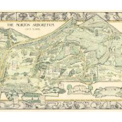
Morton Arboretum Map (3.19479)
Date: 1943Creator: Watts, May Theilgaard
Type: Map
Description:2014 reprint of The Morton Arboretum's first color map, circa 1943.
Detailed map of Arboretum grounds, showing roads, paths, landscaping, shelters, structures, enlargement of some specific features, hedge garden, some specific trees, and trails with markers numbered 1 - 42. Other features include a scale, a calendar, and a compass rose consisting of directions depicted with leaves. A highly ornamental border includes grid marks, as well as drawings of animal tracks and detailed drawings and labels of plants. The Morton Arboretum encompassed 813 acres at time of map.
Extent: 1 sheet

Morton Arboretum Map (3.19481)
Date: 1943Creator: Watts, May Theilgaard
Type: Map
Description:Detailed map of Arboretum grounds, showing roads, paths, landscaping, shelters, structures, enlargement of some specific features, hedge garden, some specific trees, and trails with markers numbered 1 - 42. Other features include a scale, a calendar, and a compass rose consisting of directions depicted with leaves. A highly ornamental border includes grid marks, as well as drawings of animal tracks and detailed drawings and labels of plants. Some replacement illustration and text has been adhered to the map. The Morton Arboretum encompassed 813 acres at time of map. One section is partially missing.
Extent: 1 sheet

General Information and Guide Map of The Morton Arboretum (3.34267)
Date: 1941Type: Map
Description:Doublesided brochure with general information and a guide map of The Morton Arboretum.
Guide map details Arboretum roads, trails, parking, plant collections, buildings and points of interest. Fifteen areas on the grounds highlighted in the key and identified with circled numbers on the map. Surfaced roads, gravel roads, and paths distinguished on the map by the type of line drawn. Compass showing directions north, south, east, west as well as scale indicator above top center of map.
Reverse side provides general information about the Arboretum, rules and regulations, and information about the Arboretum publication, Bulletin of Popular Information.
Extent: 1 sheet

General Information and Guide Map of The Morton Arboretum (3.34268)
Date: 1942Type: Map
Description:Doublesided brochure with general information and a guide map of The Morton Arboretum.
Guide map details Arboretum roads, trails, parking, plant collections, buildings and points of interest. Vegetation illustrated throughout map. Three stylized trees under compass showing directions north, south, east, west as well as scale indicator above top center of map.
Reverse side provides general information about the Arboretum, rules and regulations, outstanding features, buildings, Arboretum publications, and location.
Extent: 1 sheet

Clarence Godshalk's second Arboretum house (Superintendent's Residence), exterior front view in winter with new high roof added in 1940 (3.38215)
Date: 1940sType: Photographic image
Description:Clarence Godshalk's second Arboretum house (Superintendent's Residence), exterior front view in winter with new high roof added in 1940
Extent: 1 photograph
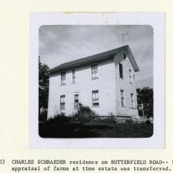
Charles Schroeder residence on Butterfield Road, taken for appraisal of farms at time estate was transferred (3.38238)
Date: 1940sType: Photographic image
Description:Charles Schroeder residence on Butterfield Road, taken for appraisal of farms at time estate was transferred
Extent: 1 photograph
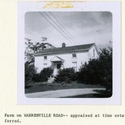
Farm on Warrenville Road, appraised at time estate was transferred (3.38239)
Date: 1940sType: Photographic image
Description:Farm on Warrenville Road, appraised at time estate was transferred
Extent: 1 photograph
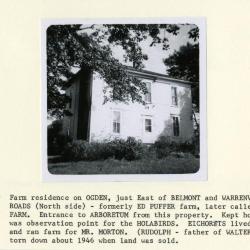
Farm residence on Ogden, formerly Ed Puffer farm, later called Arbor Farm (3.38240)
Date: 1940sType: Photographic image
Description:Farm residence on Ogden, just east of Belmont and Warrenville Roads (north side), formerly Ed Puffer farm, later called Arbor Farm. Entrance to Arboretum from this property. Kept hogs. Pond was observation point for the Holabirds. Eickhorsts lived there and ran farm for Mr. Morton. (Rudolph Eickhorst, father of Walter Eickhorst). House torn down about 1946 when land was sold.
Extent: 1 photograph
Remodeling of Farmhouse: T. H. Slusser (3.5481)
Date: April 1947Creator: Polito, Frank
Type: Plan
Description:Sheet 1 has subtitle: Planting plan, by Ralph Rodney Root, Landscape Engineer.
Extent: 2 sheets stapled
Remodeling of Farmhouse: T. H. Slusser; Foundation Plan for T. H. Slusser (3.5483)
Date: circa 1947Creator: Polito, Frank
Type: Plan
Description:Foundation plan for T. H. Slusser.
Extent: 1 sheet
Remodeling of Farmhouse: T. H. Slusser; Fireplace Details (3.5484)
Date: circa April 1947Creator: Polito, Frank
Type: Plan
Description:Fireplace details for Mr. Thomas H. Slusser: living elevation.
Extent: 1 sheet
Remodeling of Farmhouse: T. H. Slusser; Fireplace: Alternate Elevation (3.5485)
Date: circa April 1947Creator: Polito, Frank
Type: Plan
Description:Fireplace for Mr. Thomas H. Slusser: alternate elevation.
Extent: 1 sheet
[A development plan for a residential community in the Arboretum] (3.5763)
Date: 1940sCreator: Schafer, Joe
Type: Plan
Description:A landscape design developed in connection with planning for Arbordale. The community shown here was projected for the area south and east of South Farm. The plan was drawn on the Lozier/Steinbrecher Assessment plat no. 1 (Lands Belonging To Trustees Under The Will Of Joy Morton, Deceased) issued Sept. 29, 1934 (See SURV:B III (b) 1). Authorship was assigned by C. E. Godshalk in a ms. note. Additions added in colored pencil.
Extent: 1 sheet
[A Development Plan for a Residential Community Within the Arboretum] (3.5766)
Date: 1940sCreator: Godshalk, Clarence E.
Type: Plan
Description:A landscape design developed in connection with planning for Arbordale. The community shown here was projected for an area roughly the same as that occupied currently by Arbordale. The plan was drawn on the Lozier/Steinbrecher Assessment plat no. 1 issued Sept. 29, 1934
Authorship is shown in a ms. note written on the map by C.E. Godshalk: "CEG did this."
Extent: 1 sheet
Superintendent's Residence at the Morton Arboretum, Near Lisle, Illinois, New Roof and Dormer Windows (3.6375)
Date: February 26 1940Creator: Holabird & Root
Type: Plan
Description:Includes 10 page stapled booklet of "Memorandum Specifications for New Roof."
Extent: 1 sheet and booklet
Superintendent's Residence at the Morton Arboretum Near Lisle, Illinois, New Roof and Dormer Windows (3.6377)
Date: February 26 1940Creator: Holabird & Root
Type: Plan
Description:Includes red pencil corrections and revision note that says "Electric outlet added 4/17/40."
Extent: 1 sheet