Browsing by Subject/Keyword: century:
1991/03/04: Gerard Donnelly to Gerould Wilhelm (3.44243)
Date: March 4 1991Creator: Donnelly, Gerard T.
Type: Document
Description:Memo from Gerard Donnelly to Gerould Wilhelm reviewing a research proposal on the restoration and management of different Arboretum plant communities, including two overlay sheets on the maps in the research proposal.
Extent: 14 sheets
1991/04/08: Memo from Gerard T. Donnelly to George Ware, Duane Henry, and Craig Johnson (3.38497)
Date: April 8 1991Creator: Donnelly, Gerard T.
Type: Document
Description:Arboretum memo from Gerard T. Donnelly to George Ware, Duane Henry, and Craig Johnson deliniating a procedure to determine responsibilities in regards to controlled burns.
Extent: 1 sheet
Access Map, Schulenberg Prairie of the Morton Arboretum (3.6332)
Date: 1989 – 1990Creator: Butkovich, Dianne
Type: Map
Description:Marked "Not using"
Extent: 1 sheet

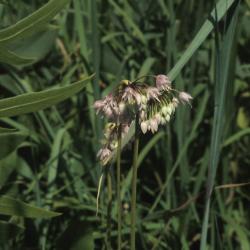
Allium cernuum (Nodding Wild Onion), flower, full (3.69286)
Date: August 27 1976Creator: Hedborn Jr., Edward A.
Type: Photographic image
Description:Allium cernuum (Nodding Wild Onion), flower, full
Allium cernuum (Nodding Wild Onion), inflorescence (3.69297)
Date: August 21 1976Creator: Hedborn Jr., Edward A.
Type: Photographic image
Description:Allium cernuum (Nodding Wild Onion), inflorescence

Allium cernuum (Nodding Wild Onion), inflorescence (3.69298)
Date: August 27 1976Creator: Hedborn Jr., Edward A.
Type: Photographic image
Description:Allium cernuum (Nodding Wild Onion), inflorescence

Asclepias sullivantii (Sullivant's Milkweed), flower, full, bud, flower (3.80727)
Date: July 3 1976Creator: Hedborn Jr., Edward A.
Type: Photographic image
Description:Asclepias sullivantii (Sullivant's Milkweed), flower, full, bud, flower
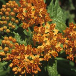
Asclepias tuberosa (Butterfly Milkweed), flower, full, bud, flower (3.80804)
Date: July 3 1976Creator: Hedborn Jr., Edward A.
Type: Photographic image
Description:Asclepias tuberosa (Butterfly Milkweed), flower, full, bud, flower
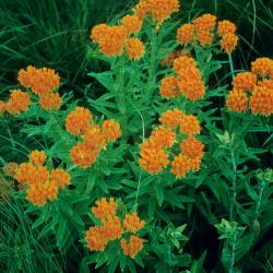
Asclepias tuberosa (Butterfly Milkweed), habit, summer (3.80815)
Date: July 1 1970Creator: Hedborn Jr., Edward A.
Type: Photographic image
Description:Asclepias tuberosa (Butterfly Milkweed), habit, summer
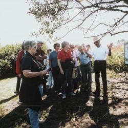
Bob Betz leading group tour of Schulenberg Prairie (3.3582)
Date: 1987Creator: Irving, Gary
Type: Photographic image
Description:Bob Betz (far right) leading group tour of Schulenberg Prairie
Charles Lewis and Sherry (Rubino) Lewis at center left
Extent: 1 photograph
Dalea candida (White Prairie Clover), fruit, immature (3.83979)
Date: July 3 1976Creator: Hedborn Jr., Edward A.
Type: Photographic image
Description:Dalea candida (White Prairie Clover), fruit, immature
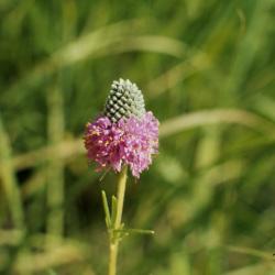
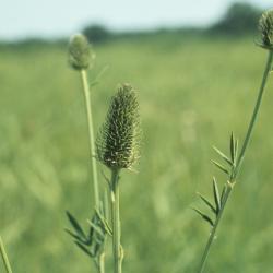
Dalea purpurea (Purple Prairie-clover), flower, full (3.83984)
Date: July 3 1976Creator: Hedborn Jr., Edward A.
Type: Photographic image
Description:Dalea purpurea (Purple Prairie-clover), flower, full
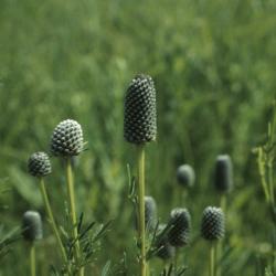
Dalea purpurea (Purple Prairie-clover), inflorescence (3.83991)
Date: July 3 1976Creator: Hedborn Jr., Edward A.
Type: Photographic image
Description:Dalea purpurea (Purple Prairie-clover), inflorescence
Interpretive Trail, Willoway Creek at The Morton Arboretum (3.7088)
Date: January 26 1998Creator: Mehaffey, Scott A.
Type: Plan
Extent: 3 sheets
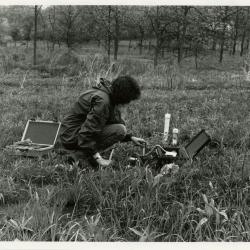
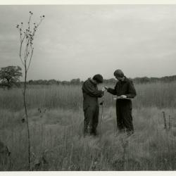
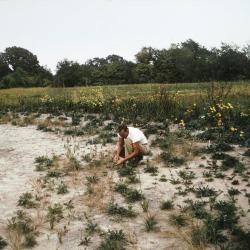
Kim Allen monitoring soil moisture in Schulenberg Prairie (3.4501)
Date: circa 1990Type: Photographic image
Description:Kim Allen monitoring soil moisture in Schulenberg Prairie
Extent: 1 photograph
Lecture by Ray Schulenberg: The Story of The Morton Arboretum Prairie Restoration (3.31580)
Date: September 11 1987Type: Audio
Description:Lecture titled "The Story of The Morton Arboretum Prairie Restoration" given by Ray Schulenberg as part of the 25th Anniversary Celebration of The Morton Arboretum Prairie.
Extent: 1 audio cassette

Map & Visitor Guide, The Morton Arboretum (3.34271)
Date: 1982 – 1986Type: Map
Description:Double-sided brochure, Map & Visitor Guide for The Morton Arboretum
Map details Arboretum roads, trails, plant collections, buildings and boundaries. Includes photographs of various Arboretum buildings with descriptive information.
Reverse side provides general information about the Arboretum, trails for walking and hiking, driving through the Arboretum, areas and collections of special interest, native plant communities, wildlife at the Arboretum, regulations, facilities and services, and information on membership. A section of the map is enlarged to identify landmarks around the Visitor Center, Administration Building, and Thornhill Education Center.
Extent: 1 sheet
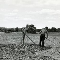
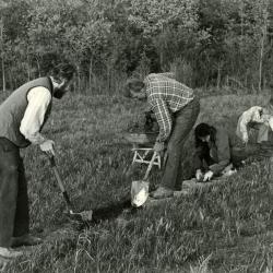
Men hoeing ground to plant prairie (3.3561)
Date: 1970sCreator: Stickney, William S.
Type: Photographic image
Description:Men hoeing ground to plant prairie
Extent: 1 photograph
Pat Kelsey (left) and Rick Hootman soil testing in the prairie (3.4515)
Date: 1986 – 1987Type: Photographic image
Description:Pat Kelsey (left) and Rick Hootman soil testing in the prairie
Extent: 1 photograph
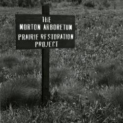
Prairie Restoration Project sign at old prairie (3.3558)
Date: 1970sType: Photographic image
Description:Prairie Restoration Project sign at old prairie
Extent: 1 photograph
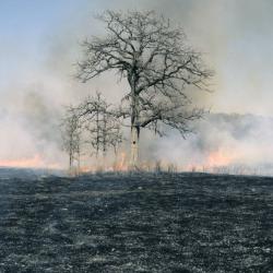
Quercus macrocarpa (Bur Oak), habitat, fire (3.46549)
Date: 1998Creator: Hedborn Jr., Edward A.
Type: Photographic image
Description:Quercus macrocarpa (Bur Oak), habitat, fire
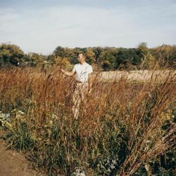
Ray Schulenberg in fall prairie with big bluestem (3.3584)
Date: 1970sType: Photographic image
Description:Ray Schulenberg in fall prairie with big bluestem
Extent: 1 photograph
Ray Schulenberg planting plugs in the prairie (3.3583)
Date: 1970sType: Photographic image
Description:Ray Schulenberg planting plugs in the prairie
Extent: 1 photograph
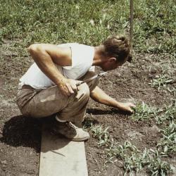
Ray Schulenberg planting plugs in the prairie (3.3586)
Date: 1970sType: Photographic image
Description:Ray Schulenberg planting plugs in the prairie
Extent: 1 photograph
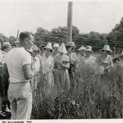
Ray Schulenberg speaking to group of women in the prairie (3.5134)
Date: 1964 – 1965Creator: Purrington, Frank L.
Type: Photographic image
Description:Ray Schulenberg speaking to group of women in the prairie
Extent: 1 photograph
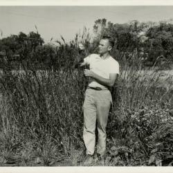
Ray Schulenberg studying plant in prairie during prairie restoration (3.5137)
Date: 1963Type: Photographic image
Description:Ray Schulenberg studying plant in prairie during prairie restoration
Extent: 1 photograph
Soils Mapped on the Schulenberg Prairie of the Morton Arboretum (3.6772)
Date: 1990Creator: Hootman, Rick, Allen, Kimberly
Type: Map
Description:Key names of soil series and percent of slopes.
Extent: 1 sheet on board
Stream stabilization, Willoway Creek at the Morton Arboretum, DuPage County, Illinois (3.7085)
Date: January 7 – 20 1998Creator: Rust Environment & Infrastructure
Type: Map
Extent: 8 sheets
Stream stabilization, Willoway Creek at the Morton Arboretum, DuPage County, Illinois (3.7086)
Date: January 7 – 20 1998Creator: Rust Environment & Infrastructure
Type: Map
Extent: 1 sheet
Stream stabilization, Willoway Creek at the Morton Arboretum, DuPage County, Illinois (3.7087)
Date: January 7 – 20 1998Creator: Rust Environment & Infrastructure
Type: Map
Extent: 1 sheet
The Schulenberg Prairie of The Morton Arboretum (3.6394)
Date: 1987Type: Plan
Description:Sign design.
Extent: 1 sheet
Topographic Map of Willoway Creek Area Along Schulenberg Prairie by K.A. Altvatter, Richard G. Hootman, and Patrick D. Kelsey (3.6105)
Date: 1989Creator: Allen, Kimberly
Type: Map
Description:Individual location elevations.
Extent: 1 sheet
Topographic Map of Willoway Creek Area Along Schulenberg Prairie by K.A. Altvatter, Richard G. Hootman, and Patrick D. Kelsey [ink on mylar] (3.6106)
Date: 1989Creator: Allen, Kimberly
Type: Map
Description:Copy 3 is an ink on mylar topographic map 220 cm x 92 cm (scale is 1 inch = 20 feet).
Extent: 1 sheet
Topographic Map of Willoway Creek Area Along Schulenberg Prairie by K.A. Altvatter, Richard G. Hootman, and Patrick D. Kelsey [preliminary] (3.6104)
Date: 1989Creator: Allen, Kimberly
Type: Map
Description:# 810 (3.6038) is stamped PRELIMINARY, but it is a duplicate of copy 1, # 876 (3.6104) which is not marked as preliminary. Recorded # 810 as a duplicate in this record.
Extent: 1 sheet
Volunteers at work in the prairie, laying stones for path (3.3560)
Date: 1970sType: Photographic image
Description:Volunteers at work in the prairie, laying stones for path
Extent: 1 photograph
Wood Valley Estates [development plan for a tract on the Slusser Farm] (3.5826)
Date: April 16 1958Creator: Steinbrecher, Harold F.
Type: Plan
Description:A private housing development, never carried out, on an area in the southwest corner of the Arboretum bordering Leask Lane. The area is currently within the Schulenberg Prairie of the Arboretum.
Extent: 1 sheet