1986/10/13: Rick Hootman to George Ware et al. (3.37614)
Date: October 13 1986Creator: Hootman, Rick
Type: Document
Description:Arboretum memo from Rick Hootman to Dr. Hall, Charles Lewis, Tony Tyznik, George Ware, and Duane Henry. Notes from meeting of Oct. 9, 1986 concerning berm erosion, berm plants, and new amenity lake.
Extent: 2 sheets
A Berm Detail for the Morton Arboretum [of the southern boundary] (3.5269)
Date: 1988Creator: Tyznik, Anthony
Type: Map
Description:Revised version of the Western section issued in June, 1988.
Extent: 1 sheet
A Berm Detail for The Morton Arboretum [of the southern boundary] (3.6764)
Date: December 12 1986Creator: Tyznik, Anthony
Type: Map
Description:A revision of SURV:A III (c) 1 (3.6763)
Extent: 2 sheets
A Berm Detail for the Morton Arboretum [of the southern boundary] [ink drawing on parchment] (3.6763)
Date: February 1986Creator: Tyznik, Anthony
Type: Map
Description:Set of topographic maps giving berm elevations along the East-West Tollway from the Route 53 intersection to the eastern boundary of the Arboretum. Coverage of the area is given as follows: [1] Western section inclusive of the King's grove area; [2] Central section inclusive of the area into the East Woods; [3] Puffer marsh area.
Collection has a revised version of the Western section issued in June, 1988 and a CD scan by Pat Kelsey, 4-18-2006.
Extent: 3 sheets

A Guide Map of The Morton Arboretum (3.34269)
Date: 1969Creator: Tyznik, Anthony
Type: Map
Description:A guide map of The Morton Arboretum created by Tony Tyznik in 1969. The background is a dark green with the inner Arboretum being a light green and Arboretum roads highlighted in solid orange and checkered orange lines.
Extent: 1 sheet
A Landscape Development Plan for the Tollway Berm - West Section [10/1989, colored] (3.6527)
Date: October 1989Creator: Tyznik, Anthony
Type: Plan
Description:This copy includes colored pencil shading.
Extent: 2 sheets, attached with tape
A Landscape Development Plan for the Tollway Berm - West Section [10/1989] (3.6526)
Date: October 1989Creator: Tyznik, Anthony
Type: Plan
Extent: 2 sheets
A Landscape Development Plan for the Tollway Berm, West and East Sections, The Morton Arboretum [10/1992, colored, including pencil modifications] (3.6530)
Date: October 1992Creator: Tyznik, Anthony
Type: Plan
Description:Partially colored with colored pencil and includes pencil corrections.
Extent: 2 sheets
A Landscape Development Plan for the Tollway Berm, West and East Sections, The Morton Arboretum [10/1992] (3.6529)
Date: October 1992Creator: Tyznik, Anthony
Type: Plan
Extent: 2 sheets
A [Proposed] Landscape Screen Planting Plan for the Northern Illinois Gas Company Valve Nest (3.6454)
Creator: Tyznik, Anthony
Type: Plan
Description:East side near Commonwealth Edison tower; perhaps located south of East-West Tollway
Extent: 1 sheet
Access map, Morton Arboretum (3.6329)
Date: 1989 – 1990Creator: Butkovich, Dianne
Type: Map
Extent: 1 sheet
Access map, Morton Arboretum (3.6330)
Date: 1989 – 1990Creator: Butkovich, Dianne
Type: Map
Extent: 1 sheet
Access map, Morton Arboretum (3.6331)
Date: 1989 – 1990Creator: Butkovich, Dianne
Type: Map
Extent: 1 sheet
Assessment Plat No. 1, Lands Belonging to Trustees Under the Will of Joy Morton, Deceased, Lisle, Township, DuPage County, Illinois (3.5305)
Date: September 29 1934Creator: Lozier, J. S.
Type: Map
Description:Surveys a "U"-shaped area, 94.056 acres, that spans Route 53 and extends northward from Warrenville Road into the South Farm area. The major interchange of the East-West Tollway and Route 53 is located within the present day tract.
Extent: 1 sheet
Berm Landscape Plan - West Section and East Section [11/1992, additional handwritten notes] (3.32004)
Date: November 17 – 19 1992Creator: Tyznik, Anthony
Type: Plan
Description:West section is on sheets 1 and 2, east section on sheets 3-6.
Handwritten plant changes on plan.
Extent: 6 sheets bound and stapled
Berm Plan - West Section and East Section [03/1993, latest version] (3.6538)
Date: March 16 1993Creator: Tyznik, Anthony
Type: Plan
Description:West section is on sheets 1 and 2, east section on sheets 3-6.
Includes note: "copy with Bachtell's amendments, latest version March 16, 1993."
Missing sheet 6.
Extent: 5 sheets
Berm Plan - West Section and East Section [11/1992] (3.6537)
Date: November 17 – 19 1992Creator: Tyznik, Anthony
Type: Plan
Description:West section is on sheets 1 and 2, east section on sheets 3-6.
Extent: 6 sheets

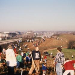
Bill Hess and others planting tree on top of berm during Earth Day celebration and berm planting (3.57683)
Date: May 1990Creator: Luthringer, Ruth
Type: Photographic image
Description:Bill Hess and others planting tree on top of berm during Earth Day celebration and berm planting
Extent: 1 slide
Concept Design for I-88 and Route 53 Interchange Landscape, Scheme A (3.32006)
Date: December 15 2004Creator: Mehaffey, Scott A.
Type: Plan
Extent: 1 sheet
Concept Design for I-88 and Route 53 Interchange Landscape, Scheme B (3.32007)
Date: December 15 2004Creator: Mehaffey, Scott A.
Type: Plan
Extent: 1 sheet
Concept Design for I-88 and Route 53 Interchange Landscape, Scheme C (3.32008)
Date: December 15 2004Creator: Mehaffey, Scott A.
Type: Plan
Extent: 1 sheet
Concept Park Boulevard Entrance (3.47501)
Date: January 9 2001Creator: Christopher B. Burke, Engineering West, Ltd.
Type: Map
Description:Color aerial map showing existing entrance and exit to be removed and proposed entrance, exit, and parking facility in 2001.
"Project No. 00-910"
Extent: 1 Sheet
Crabapple Injury Assessment, East Malus Collection, The Morton Arboretum, 1984-1985 (3.6039)
Date: 1985Creator: Green, Tom
Type: Map
Extent: 1 sheet
Cross-Sections Ramp C (3.36165)
Date: March 7 2006Creator: Bowman, Barrett & Associates, Inc.
Type: Plan
Extent: 2 sheets
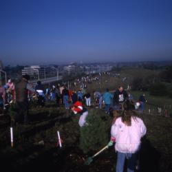
Crowd on top of berm planting trees during Earth Day celebration and berm planting (3.57697)
Date: May 1990Creator: Smith, Shannon
Type: Photographic image
Description:Crowd on top of berm planting trees during Earth Day celebration and berm planting
Extent: 1 slide
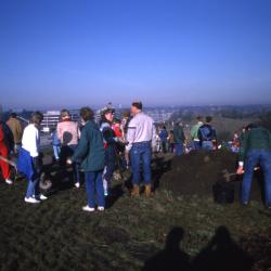
Crowd on top of berm with mulch pile at right and camera stand at left during Earth Day celebration and berm planting (3.57696)
Date: May 1990Creator: Smith, Shannon
Type: Photographic image
Description:Crowd on top of berm with mulch pile at right and camera stand at left during Earth Day celebration and berm planting
Extent: 1 slide
East-West Tollway [limited berm diagram] (3.67077)
Type: Document
Description:Diagram of a small portion of the Illinois East-West Tollway berm and its limiting effects on the Morton Arboretum.
Extent: 1 sheet
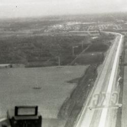
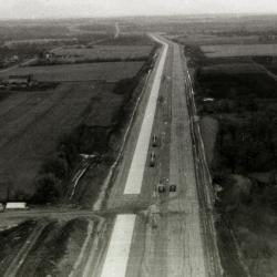
East/West Tollway and Arbor Lake construction, aerial view (3.44603)
Date: circa 1957Type: Photographic image
Description:East/West Tollway and Arbor Lake construction, aerial view
Extent: 1 filmstrip
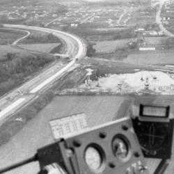
East/West Tollway construction near The Morton Arboretum, aerial view (3.44601)
Date: circa 1957Type: Photographic image
Description:East/West Tollway construction near The Morton Arboretum, aerial view
Extent: 1 filmstrip
East/West Tollway construction near The Morton Arboretum, aerial view (3.44602)
Date: circa 1957Type: Photographic image
Description:East/West Tollway construction near The Morton Arboretum, aerial view
Extent: 1 filmstrip
Existing and proposed watersheds, North-South Tollway plan (3.5865)
Date: March 1 1986Creator: Illinois State Toll Highway Authority
Type: Map
Description:The principal title above appears in ms. added to drawing 6 in the State Toll Highway Authority's aerial survey on which the plan for the North-South Tollway was drawn in (See BOUND:C III (c) 1). Watershed features are also drawn in in this work which appears in 3 sheets labelled in ms.: drawing no. 88-89, and 91.
Extent: 3 sheets stapled

Experimental devices to catch salt from East-West Tollway near Puffer Lake (3.31922)
Date: January 1972Type: Photographic image
Description:Arboretum scientists have installed experimental devices at intervals to catch salt and other fallout at various distances from the East-West Tollway near Puffer Lake.
Extent: 1 negative
Groups of people scattered along berm, including Bill Hess with shovel in foreground, during Earth Day celebration and berm planting (3.57682)
Date: May 1990Creator: Luthringer, Ruth
Type: Photographic image
Description:Groups of people scattered along berm, including Bill Hess with shovel in foreground, during Earth Day celebration and berm planting
Extent: 1 slide
Highway improvements, vicinity of Morton Arboretum, and related Arboretum traffic system (3.6060)
Date: October 18 1956Creator: George W. Barton and Associates
Type: Map
Extent: 1 sheet
I-88 & Route 53 Interchange Landscape Plan [revision 4] (3.31974)
Date: December 15 2009Creator: Gravel, David, Jacobson, Susan L. B., ehdd, inc.
Type: Plan
Description:Planting plan and design heavily notated in ink listing possible plant choices and issues with these choices, revision 4
Extent: 1 sheet
I-88 & Route 53 Interchange Landscape Plan [revision 4] (3.31975)
Date: December 15 2009Creator: Gravel, David, Jacobson, Susan L. B.
Type: Plan
Description:Planting plan and design, revision 4
Specifies sheet 1 of 5, but sheets 2 through 5 not present
Sticky note attached with plant names: "Aesculus arnoldiana 'Autumn Splendor' or Aesculus flava due to fungal disease on H. [A?] hippocastanum; ?Perennial nature of Echinaceae?"
Extent: 1 sheet