Browsing by Subject/Keyword: decade:
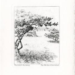
Notecards: Views of the Arboretum (3.27751)
Date: 1940 – 1960Creator: Watts, May Theilgaard
Type: Print
Description:Nine notecards showing 5 different views of The Morton Arboretum. Notecards are black ink etchings on cream paper, folded, with a deckle edge, accompanied by nine matching cream envelopes with a deckle edge and housed in a two-sided, gray leatherette portfolio with an orange paper tie. All notecards are blank with the exception of one which has a letter written inside.
Text in blue on front of the portfolio: THE MORTON ARBORETUM LISLE, ILLINOIS
Title on the bottom left and The Morton Arboretum on the bottom right of each notecard:
- From the hedge collection [1 card]
- Illustration depicts stone steps leading up to hedge collection and evergreen trees
- Along a small stream [3 cards]
- Illustration depicts a stream, bridge, tress, and shrubbery in winter
- Thornhill Building [2 cards]
- Illustration depicts view up the hill to the Thornhill building, with bare trees and mushrooms in foreground, clouds and trees behind building in background
- Along walk to Thornhill Building [2 cards, one containing correspondence regarding plans for a field trip]
- Illustration depicts trees and flowers in forest
- White oak [1 card]
- Illustration depicts a winter white oak in forest with shrubbery
Extent: 9 notecards with envelopes
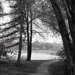
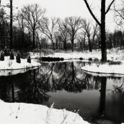
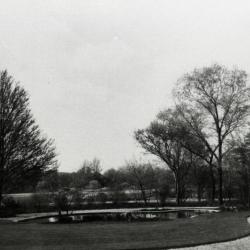
Meadow Lake along Illinois Trees Trail Loop (3.31782)
Date: 1969Type: Photographic image
Description:Meadow Lake along Illinois Trees Trail Loop
Extent: 1 negative
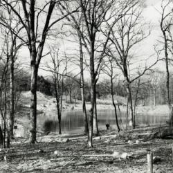
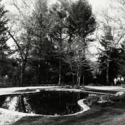
View of Sterling Pond looking north from Clarence Godshalk's yard in winter (3.31809)
Date: 1960sType: Photographic image
Description:View of Sterling Pond looking north from Clarence Godshalk's yard in winter. Open area across Sterling Pond used to be a gravel pit before 1959 when pond was dug.
Extent: 1 negative filmstrip
Sterling Pond looking north through bare trees from Clarence Godshalk's yard (3.31810)
Date: 1960sType: Photographic image
Description:Sterling Pond looking north through bare trees from Clarence Godshalk's yard. Open area across Sterling Pond used to be a gravel pit before 1959 when pond was dug.
Extent: 1 negative filmstrip
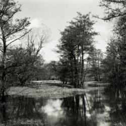
Pond west of Sterling Pond Bridge over inlet in winter (3.31811)
Date: 1960sType: Photographic image
Description:Pond west of Sterling Pond Bridge over inlet in winter
Extent: 1 negative filmstrip
Sterling Pond looking north from Clarence Godshalk's yard (3.31812)
Date: 1960sType: Photographic image
Description:Sterling Pond looking north from Director Clarence Godshalk's yard. Open area across Sterling Pond used to be a gravel pit before 1959 when pond was dug.
Extent: 1 negative filmstrip
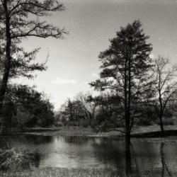
Sterling Pond looking north (3.31813)
Date: 1960sType: Photographic image
Description:Sterling Pond looking north
Extent: 1 negative filmstrip

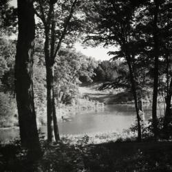
Pond on south side of Japanese Island in winter (3.31814)
Date: 1960sType: Photographic image
Description:Pond on south side of Japanese Island in winter
Extent: 1 negative filmstrip
Pond on south side of Japanese Island (3.31815)
Date: 1960sType: Photographic image
Description:Pond on south side of Japanese Island
Extent: 1 negative filmstrip

Old Route 53 two lane bridge over DuPage River (3.33537)
Date: 1960sType: Photographic image
Description:Old Route 53 two lane bridge over DuPage River
New highway bridge being built in background
Extent: 1 negative filmstrip

A Guide Map of The Morton Arboretum (3.34269)
Date: 1969Creator: Tyznik, Anthony
Type: Map
Description:A guide map of The Morton Arboretum created by Tony Tyznik in 1969. The background is a dark green with the inner Arboretum being a light green and Arboretum roads highlighted in solid orange and checkered orange lines.
Extent: 1 sheet

Lake Marmo stream overflow in winter (3.36860)
Date: December 1969Type: Photographic image
Description:Lake Marmo stream overflow in winter
Extent: 1 negative

Lake Marmo bridge and dam overflow (3.36861)
Date: July 1969Type: Photographic image
Description:Lake Marmo bridge and dam overflow
Extent: 1 negative
Administration Building lily pond, view from building entrance (3.38484)
Date: 1961Type: Photographic image
Description:Administration Building lily pond, view from building entrance
Extent: 1 filmstrip
Administration Building lily pond, visitors walking up path (3.38486)
Date: 1950 – 1969Type: Photographic image
Description:Administration Building lily pond, visitors walking up path
Extent: 1 filmstrip
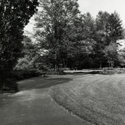
Path leading up to Administration Building lily pond (3.38487)
Date: 1950 – 1969Type: Photographic image
Description:Path leading up to Administration Building lily pond
Extent: 1 filmstrip
Morton Arboretum [Aerial Photograph and] Conservation Plan Map, Kane-DuPage Soil Conservation District. (3.5416)
Date: June 1964Creator: U.S. Soil Conservation Service
Type: Map
Description:Photomosaic produced from aerial photographs believed to have been taken in the 1940s. "Photo nos. BWS-8N-11, 8N-12, 8N-13, 4N-63, 4N-64, 4N-65, 4N-66, &4N-67." The photograph has been marked in ink with water features and major highways.
Extent: 1 sheet