
Vegetation of the Chicago Region as Mapped by the Public Land Survey 1821-1845 (3.113833)
Date: 2014Creator: Halsey, Sam, McBride, Jenny
Type: Map
Description:A map created in 2006 portraying vegetation of the Chicago Region from 1821-1845.

Vegetation of the Northwest Indiana as Mapped by the Public Land Survey 1829-1835 (3.113834)
Date: 2015Creator: McBride, Jenny, Halsey, Sam
Type: Map
Description:A map created in 2006 portraying vegetation of Northwest Indiana from 1829-1835.

Vegetation of the Southwest Michigan as Mapped by the Public Land Survey 1828-1842 (3.113835)
Date: 2015Type: Map
Description:A map created in 2006 portraying vegetation of Southwest Michigan from 1828-1942.

Vegetation of the Southeast Wisconsin as mapped by the Public Land Survey 1833-1836 (3.113836)
Date: 2015Creator: Halsey, Sam
Type: Map
Description:A map created in 2006 portraying vegetation of Southeast Wisconsin from 1833-1836.

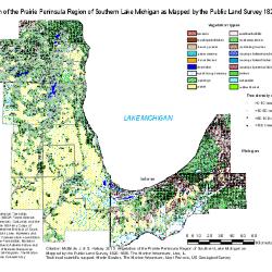
Vegetation of the Prairie Peninsula Region of Southern Lake Michigan as Mapped by the Public Land Survey 1829-1835 (3.113837)
Date: 2015Creator: Halsey, Sam, McBride, Jenny
Type: Map
Description:A map created in 2006 portraying vegetation of Prairie Peninsula Region of Southern Lake Michigan from 1829-1835.
Grassland-Forest Transition in the Prairie Peninsula Region of Northwest Indiana as Recorded by the US Public Land Survey (1829-1835) as part of a Report to the Indiana Department of Natural Resources, Lake Michigan Coastal Program (3.54103)
Date: 2015Creator: Bowles, Marlin L., Halsey, Sam, McBride, Jenny
Type: Article
Comparison of reintroduction and enhancement effects on metapopulation viability (3.55354)
Date: 2015Creator: Halsey, Sam, Bell, Timothy J.
Type: Article
Predicting population viability of a monocarpic perennial dune thistle using individual-based models (3.55437)
Date: 2017Creator: Halsey, Sam, Bell, Timothy J., Bowles, Marlin L.
Type: Article
Historic Vegetation Maps (3.91112)
Date: 2014 – 2015Creator: McBride, Jenny, Halsey, Sam
Type: Document
Description:Maps of the Chicago region showing historic vegetation as mapped by the Public Land Survey, 1829-1845. Areas include northeastern Illinois, parts of Wisconsin, Indiana, and Michigan, and a map showing the whole region.