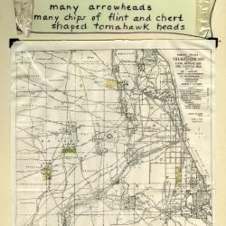
Arboretum Landscape Teaching Aid Series: Indian Trails and Villages (3.19508)
Date: 1940 – 1960Creator: Watts, May Theilgaard
Type: Drawing
Description:Primarily textual teaching aid depicting Arboretum landscape. This material describes a Native American chipping station and village located on what later became The Morton Arborteum grounds. It also includes a map showing locations of other Native American sites and trails throughout the Chicagoland area. An arrowhead wrapped in plastic is still attached on the left, while a second arrowhead appears to be missing on the right.
Header: INDIANS had a chipping station and a village here ----
Text and illustrations from top to bottom:
- [Depicted in stylized scroll] [Arrowhead wrapped in plastic] THE RECORD many arrowheads many chips of flint and chert shaped tomahawk heads [plastic wrapping]
- Map: INDIAN TRAILS AND VILLAGES OF CHICAGO AND OF COOK, DUPAGE AND WILL COUNTIES, ILLS. (1804) AS SHOWN BY WEAPONS AND IMPLEMENTS OF THE STONE-AGE / COPYRIGHTED 1900 & 1901 ALBERT F. SCHARF. / - INDEX - [with map symbols]
- INDIAN VILLAGES (NUMBERED) [teepee symbol]
- MINOR INDIAN VILLAGES [triangle with "x" at top]
- INDIAN CAMPS [triangle]
- CHIPPING STATIONS [inverted triangle]
- PRINCIPAL INDIAN TRAILS LETTERED AND NUMBERED [line]
- PORTAGE [concave depression]
- SPRINGS [inverted "J"]
- HEIGHTS AND SIGNAL STATIONS [cross]
- INDIAN MOUNDS [circle with dot in center]
- MOUND BUILDERS TRAIL [mound symbol]
- Text at bottom of map: AN ARCHEOLOGICAL MAP OF CHICAGO AND VICINITY / This map, the work of Albert F. Scharf, is reproduced by the courtesy of Mr. Scharf and the Chicago Historical Society.
- Text below map: Arboretum in green
Extent: 1 sheet
A complete history of Illinois from 1673 to 1873 : embracing the physical features of the country, its early explorations, aboriginal inhabitants, French and British occupation, conquest by Virginia, territorial condition, and the subsequent civil, military and political events of the state / by Alexander Davidson and Bernard Stuvé. (3.20763)
Date: 1874Creator: Davidson, Alexander.
Type: Book
Extent: x, 944 p. 25 cm.
The Morton Arboretum Quarterly V. 04 No. 04 (3.34565)
Date: December 21 1968 – March 20 1969Type: Serial
Description:
- The Arboretum Landscape – A Sesquicentennial Perspective (49-61)
- Blue Beech, Carpinus caroliniana: Birch Family (Betulaceae) (62-63)
- The Lookout/ Climatological Summary (64)
Extent: 16 pages
Atlas of the State of Illinois, to which are added various general maps, history, statistics and illustrations (3.37835)
Date: 1876Type: Book
Extent: 293 pages, illustrations, portraits, color maps (5 folded) 46 cm
A gazetteer of Illinois : in three parts, containing a general view of the state, a general view of each county, and a particular description of each town, settlement, stream, prairie, bottom, bluff, etc., alphabetically arranged (3.37843)
Date: 1837Creator: Peck, John Mason, 1789-1858.
Type: Book
Extent: xi, 328 pages ; 15 cm
The pioneer history of Illinois : containing the discovery, in 1673, and the history of the country to the year eighteen hundred and eighteen, when the state government was organized (3.37847)
Date: 1852Creator: Reynolds, John, 1788-1865
Type: Book
Extent: 348 pages ; 17 cm
1976/04/12: Robbin Moran to George Ware (3.40004)
Date: April 12 1976Creator: Moran, Robbin
Type: Document
Description:A letter from Robbin Moran to George Ware asking him to review a draft of his paper on the presettlement vegetation of Lake County. A draft copy of the paper is enclosed along with the original envelope.
Extent: 31 sheets, 1 envelope