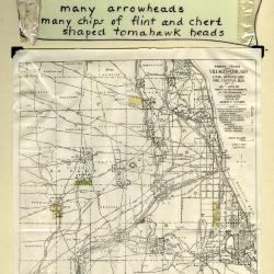
Arboretum Landscape Teaching Aid Series: Indian Trails and Villages (3.19508)
Date: 1940 – 1960Creator: Watts, May Theilgaard
Type: Drawing
Description:Primarily textual teaching aid depicting Arboretum landscape. This material describes a Native American chipping station and village located on what later became The Morton Arborteum grounds. It also includes a map showing locations of other Native American sites and trails throughout the Chicagoland area. An arrowhead wrapped in plastic is still attached on the left, while a second arrowhead appears to be missing on the right.
Header: INDIANS had a chipping station and a village here ----
Text and illustrations from top to bottom:
- [Depicted in stylized scroll] [Arrowhead wrapped in plastic] THE RECORD many arrowheads many chips of flint and chert shaped tomahawk heads [plastic wrapping]
- Map: INDIAN TRAILS AND VILLAGES OF CHICAGO AND OF COOK, DUPAGE AND WILL COUNTIES, ILLS. (1804) AS SHOWN BY WEAPONS AND IMPLEMENTS OF THE STONE-AGE / COPYRIGHTED 1900 & 1901 ALBERT F. SCHARF. / - INDEX - [with map symbols]
- INDIAN VILLAGES (NUMBERED) [teepee symbol]
- MINOR INDIAN VILLAGES [triangle with "x" at top]
- INDIAN CAMPS [triangle]
- CHIPPING STATIONS [inverted triangle]
- PRINCIPAL INDIAN TRAILS LETTERED AND NUMBERED [line]
- PORTAGE [concave depression]
- SPRINGS [inverted "J"]
- HEIGHTS AND SIGNAL STATIONS [cross]
- INDIAN MOUNDS [circle with dot in center]
- MOUND BUILDERS TRAIL [mound symbol]
- Text at bottom of map: AN ARCHEOLOGICAL MAP OF CHICAGO AND VICINITY / This map, the work of Albert F. Scharf, is reproduced by the courtesy of Mr. Scharf and the Chicago Historical Society.
- Text below map: Arboretum in green
Extent: 1 sheet

Stone tool (3.34338)
Type: Photographic image
Description:A stone tool based on Native American design for a Cub Scouts talk. It was made using linden tree bark.
Extent: 1 slide
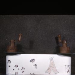
Reel drawings: Native Americans (3.34343)
Type: Photographic image
Description:Drawings on paper affixed to two sets of reels with cranks. The drawings appear to show incomplete depictions of Native American life, including a group of people, a teepee, and a pot hanging over a fire.
Extent: 1 slide
The Morton Arboretum Quarterly V. 04 No. 04 (3.34565)
Date: December 21 1968 – March 20 1969Type: Serial
Description:
- The Arboretum Landscape – A Sesquicentennial Perspective (49-61)
- Blue Beech, Carpinus caroliniana: Birch Family (Betulaceae) (62-63)
- The Lookout/ Climatological Summary (64)
Extent: 16 pages
Indian trail and villages (3.7058)
Date: 1912Creator: Scharf, Albert F.
Type: Map
Description:Scharf copyright 1900 and 1901. Blue pencil map in margin - NW 1/4 Sec. 29. This copy only lists Chicago Historical Society at bottom and 1912 date.
Extent: 1 sheet
Indian trail and villages (3.7059)
Date: 1912Creator: Scharf, Albert F.
Type: Map
Description:Scharf copyright 1900 and 1901. Includes colored pencil highlights.
Extent: 1 sheet
Indian trail and villages (3.7060)
Date: 1912Creator: Scharf, Albert F.
Type: Map
Description:Scharf copyright 1900 and 1901.
Extent: 1 sheet
Indian Days in DuPage County (3.7064)
Date: 1966Creator: Gallo, Gene
Type: Map
Description:Map shows trails, Indian settlements, pioneer cabins (Scott and Naper) and events. Sidebars describe tribes and chiefs (with drawings).
Extent: 1 sheet