[Retaining wall project] (3.31984)
Type: Plan
Description:Shows south edge of The Morton Arboretum along I-88 east of Route 53.
Extent: 1 sheet
Plan and Profile I-88 East-West Tollway Mainline (3.36164)
Creator: Bowman, Barrett & Associates, Inc.
Type: Plan
Extent: 10 sheets
[Retaining Wall, I-88 Parapet Over Route 53] (3.32017)
Type: Plan
Description:One sheet with eight elevations of I-88 parapet over Route 53, with retaining wall, abutments, and wing walls.
Extent: 1 sheet
East-West Tollway [limited berm diagram] (3.67077)
Type: Document
Description:Diagram of a small portion of the Illinois East-West Tollway berm and its limiting effects on the Morton Arboretum.
Extent: 1 sheet
A [Proposed] Landscape Screen Planting Plan for the Northern Illinois Gas Company Valve Nest (3.6454)
Creator: Tyznik, Anthony
Type: Plan
Description:East side near Commonwealth Edison tower; perhaps located south of East-West Tollway
Extent: 1 sheet
Assessment Plat No. 1, Lands Belonging to Trustees Under the Will of Joy Morton, Deceased, Lisle, Township, DuPage County, Illinois (3.5305)
Date: September 29 1934Creator: Lozier, J. S.
Type: Map
Description:Surveys a "U"-shaped area, 94.056 acres, that spans Route 53 and extends northward from Warrenville Road into the South Farm area. The major interchange of the East-West Tollway and Route 53 is located within the present day tract.
Extent: 1 sheet
Preliminary Drainage Investigations on the Mertz tract and the Mey Farm for Mr. Sterling Morton and the Estate of Joy Morton, Owners. (3.5583)
Date: 1940sCreator: Steinbrecher, Harold F.
Type: Map
Extent: 1 sheet
[Tollway Right-of-way and Easements in] Assessment Plat No. 2 (3.5370)
Date: 1950sType: Map
Description:Acreages dedicated to right-of-way are shown by colored shading. These data are shown on the plat made by J.S. Lozier and H.F. Steinbrecher titled: Assessment Plat No.2, and issued Oct.1, 1934.
Extent: 1 sheet
[Tollway Right-of-way and Easements Over the Southern Portion of the Thoman Farm] (3.5371)
Date: 1950sType: Map
Description:Acreages decicated to right -of-way are shown by colored shading. These data are shown on the composite survey copied by H.F. Steinbrecher from earlier plats titled: Plat showing the Thoman Farm, and issued ca. 1935.
Extent: 1 sheet
[Tollway Right-of-way and Easements Along Finley Road in] Assessment Plat No. 3 (3.5372)
Date: 1950sType: Map
Description:Acreages dedicated to right-of-way are shown by colored shading. These data are shown on the plat made by J.S. Lozier and H.F. Steinbrecher titled: Assessment plat no. 3, and issued Sept. 24, 1934.
Extent: 1 sheet
[Tollway Right-of-way and Easements Along Route 53 in] Assessment Plat No. 1 (3.5369)
Date: 1950sType: Map
Description:Acreages dedicated to right-of-way are shown by colored shading. These data are shown on the plat made by J.S. Lozier and H.F. Steinbrecher titled: Assessment Plat No. 1, and issued Sept.29, 1934.
Extent: 1 sheet
[Original toll road studies] (3.5885)
Date: circa 1955Creator: Godshalk, Clarence E.
Type: Map
Description:The proposed roadway is drawn in ms. on the plat survey made by H. F. Steinbrecher titled: Map showing the Morton Arboretum and the adjoining lands owned by the Joy Morton Estate (and dated Sept. 1, 1940).
Extent: 1 sheet
[Proposed East-West Tollway routes through the] Morton Arboretum. Revised. (3.5883)
Date: February 15 1955Type: Map
Description:First issued Jan. 13, 1955. "Drwg. No. 900-74-1".
Extent: 1 sheet
Traffic plan showing proposed toll road, prepared for the Morton Arboretum (3.5882)
Date: March 2 1955Creator: Associated Consultants
Type: Map
Extent: 1 sheet
Northern Illinois Toll Highway Parcel No. E-2-70, Sec. 3, T.38N., R.10E. of the 3rd P.M., DuPage County, Illinois (3.6092)
Date: 1956Creator: Illinois State Toll Highway Authority
Type: Map
Description:This map is a portion along the East-West Tollway easement in Lot 7 of Petersen-Tate Assessment Plat no. 2. This copy (Copy 2), dated from about 1956, includes surveyed area of 0.583 acres of the permanent easement.
Extent: 1 sheet
Highway improvements, vicinity of Morton Arboretum, and related Arboretum traffic system (3.6060)
Date: October 18 1956Creator: George W. Barton and Associates
Type: Map
Extent: 1 sheet
Northern Illinois Toll Highway Parcel No. E-2-23, Morton Arboretum, Section 2 & 3, T. 38N., R.10E. of the 3rd P.M., DuPage County, Illinios (3.5378)
Date: November 1 1956Creator: Illinois State Toll Highway Authority
Type: Map
Description:Area surveyed, 24.679 acres, shows interchange of East-West Tollway and Route 53. Includes notes in colored pencil.
Extent: 1 sheet
Northern Illinois Toll Highway: east-west route, plan & profile, Sta. 7520 to [Sta. 7637] Contract E-2A, Hurst-Rosche, Inc. (3.5884)
Date: 1957Creator: Illinois State Toll Highway Authority
Type: Map
Description:Sheets have the following numbering sequences: printed, "Sheet 15[-23] of 70"; stamped, 8265-8273; and in ms., 15-23.
Extent: 9 sheets stapled
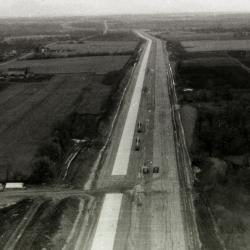
East/West Tollway construction near The Morton Arboretum, aerial view (3.44602)
Date: circa 1957Type: Photographic image
Description:East/West Tollway construction near The Morton Arboretum, aerial view
Extent: 1 filmstrip
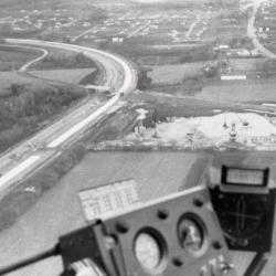
East/West Tollway and Arbor Lake construction, aerial view (3.44603)
Date: circa 1957Type: Photographic image
Description:East/West Tollway and Arbor Lake construction, aerial view
Extent: 1 filmstrip
[State Route 53 profile (Sta. 01-00 to Sta. 49+15.48), an engineering drawing for the widening and improving of the roadway] (3.5888)
Date: circa 1957Type: Map
Description:The Route 53 roadway extending from the East-West Tollway to the Valley View subdivision, showing re-routing of the road and the eastern branch of the DuPage River.
Extent: 2 sheets in binder
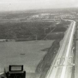
East/West Tollway construction near The Morton Arboretum, aerial view (3.44601)
Date: circa 1957Type: Photographic image
Description:East/West Tollway construction near The Morton Arboretum, aerial view
Extent: 1 filmstrip
Northern Illinois Toll Highway Parcel No. E-2-25, Morton Arboretum, Section 1 & 2, T.38N., R. 10E. of the 3rd P.M., DuPage County, Illinois (3.5381)
Date: January 24 1957Creator: Illinois State Toll Highway Authority
Type: Map
Description:Shows four tracts of Arboretum land, comprising 39.53 acres, surveyed for the East-West Tollway and Finley Road.
Extent: 1 sheet
Northern Illinois Toll Highway Parcel No. E-2-25, Morton Arboretum, Section 1&2, T.38N., R. 10E. of the 3rd P.M., DuPage County, Illinois (3.5382)
Date: January 24 1957Creator: Illinois State Toll Highway Authority
Type: Map
Description:Shows four tracts of Arboretum land, comprising 39.53 acres, surveyed for the East-West Tollway and Finley Road. Areas are outlined in colored pencil.
Extent: 1 sheet
Sketch Showing the Present and Proposed Right of Way and Easement Lines of the Proposed Toll Highway Near the Employee Residences at Morton Arboretum (3.5374)
Date: March 27 1957Creator: Steinbrecher, Harold F.
Type: Map
Description:"This sketch is approximate and is not the result of a survey made in the field." The location of four residential structures along Route 53 near South Farm, since removed, are shown.
Extent: 1 sheet
Preliminary [Survey of Commonwealth Edison Right-of-way] Except Thru Parcels 320-311 [From Butterfield Road to East-West Tollway] (3.5365)
Date: August 3 1958Creator: James, Schaeffer, & Schimming, Inc.
Type: Map
Description:Various revisions, Aug. 14, 1953 - April 21, 1954 have been incorporated into the survey. "Total of 193 trees of 10" diameter or over in the limits of the 210.00 feet strip as shown on this plat."
Extent: 2 sheets
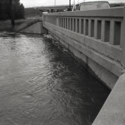
Old Route 53 two lane bridge over DuPage River (3.33537)
Date: 1960sType: Photographic image
Description:Old Route 53 two lane bridge over DuPage River
New highway bridge being built in background
Extent: 1 negative filmstrip
Morton Arboretum [Aerial Photograph and] Conservation Plan Map, Kane-DuPage Soil Conservation District. (3.5416)
Date: June 1964Creator: U.S. Soil Conservation Service
Type: Map
Description:Photomosaic produced from aerial photographs believed to have been taken in the 1940s. "Photo nos. BWS-8N-11, 8N-12, 8N-13, 4N-63, 4N-64, 4N-65, 4N-66, &4N-67." The photograph has been marked in ink with water features and major highways.
Extent: 1 sheet
Intersection design study: F. A. P. route 431 (Ill. Rte. 53 freeway) with U.S. Route 34 (Ogden Ave.) Sec. no. 22-2, DuPage County. Preliminary. (3.5846)
Date: circa 1965Creator: Tornrose, Campbell, & Assoc.
Type: Map
Description:"Preliminary print, Illinois Division of Highways, Mobility Studies Unit, subject to revisions" stamped on map. An early proposal for the North-South Tollway.
Extent: 1 sheet
Plat of Easement to the Village of Downers Grove, Illinois (3.6778)
Date: December 17 1968Creator: Wight & Company
Type: Map
Description:Survey shows area ceded by Arboretum to Downers Grove north of East-West Tollway and west of Finley Road. Includes grant of easement document describing six parcels and aerial photograph of area with red pencil notes.
Extent: 3 sheets

A Guide Map of The Morton Arboretum (3.34269)
Date: 1969Creator: Tyznik, Anthony
Type: Map
Description:A guide map of The Morton Arboretum created by Tony Tyznik in 1969. The background is a dark green with the inner Arboretum being a light green and Arboretum roads highlighted in solid orange and checkered orange lines.
Extent: 1 sheet
Plat of Survey and Topographic Map [of Arboretum land south of East-West Tollway] (3.5398)
Date: March 25 1970Creator: Steinbrecher, Harold F.
Type: Map
Description:Land shown in survey was annexed to the City of Lisle, Illinois in 1972.
Extent: 1 sheet
Plat of Survey and Topographic Map [of Arboretum land south of East-West Tollway] [no topographics] (3.6754)
Date: March 25 1970Creator: Steinbrecher, Harold F.
Type: Map
Description:Plan shown in survey was annexed to the City of Lisle in 1972.
This map doesn't show topographics. See related objects for a link to the map with topographics.
Extent: 1 sheet
Plat of Survey [of Arboretum land south of the East-West Tollway] (3.5400)
Date: February 19 1971Creator: Steinbrecher, Harold F.
Type: Map
Description:Land shown in survey was annexed to the City of Lisle, Illinois in 1972.
Extent: 1 sheet
Plat of Survey [of Arboretum land south of the East-West Tollway] [with note] (3.5401)
Date: February 19 1971Creator: Steinbrecher, Harold F.
Type: Map
Description:Land shown in survey was annexed to the City of Lisle, Illinois in 1972.
Note on survey: "Standard T Chemical Purchase 21.079 acres net."
Extent: 1 sheet

Looking south from Puffer Lake inlet across the East-West Tollway with office building in background (3.31921)
Date: January 1972Type: Photographic image
Description:Looking south from Puffer Lake inlet across the East-West Tollway with office building in background. Water is sifted, filtered, treated and stored in a natural swamp-marsh-lake sequence, helping preserve the quality and quantity of DuPage County water.
Extent: 1 negative