Browsing by Subject/Keyword: decade:
Lunching & Learning with Clarence Godshalk: Evolution of the Arboretum - From Farm to Arboretum (3.31582)
Date: January 25 1978Type: Audio
Description:Lunching and Learning program presented by Clarence Godshalk as he describes the evolution of the Arboretum, from farm land to Arboretum.
Extent: 1 audio cassette
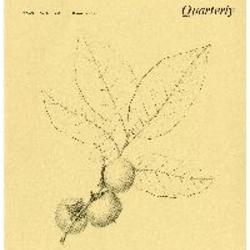
The Morton Arboretum Quarterly V. 05 No. 04 (3.34569)
Date: December 21 1969 – March 20 1970Type: Serial
Description:
- The Morton Arboretum: planning for its Second Half-Century (49-53)
- River Birch, Betula nigra: Birch Family (Betulaceae) (54-55)
- The River and the Watershed (56-64)
- Climatological Summary (64)
Extent: 16 pages
Tract Map of The Morton Arboretum 1982 Sheet 2 (3.36143)
Date: March 8 1972Creator: Steinbrecher, Harold F.
Type: Map
Description:Dated March 8, 1972. Revised on November 29, 1979. Surroundings updated on May 25, 1982.
A complied tract map of the Morton Arboretum, being parts of Sections 33, 34, 35, and 36, township 39 North, Range 10 East of the 3rd Principal Meridian, and parts of Sections 1, 2, 3, and 4,, township 38 North, Range 10 East of the third Principal Meridian in DuPage County, Illinois. [1979 ed.] (3.5408)
Date: November 29 1979Creator: Steinbrecher, Harold F.
Type: Map
Description:First issued in 1 sheet version Nov. 22, 1971. A revision was issued March 7, 1972 in 2 sheets:Map on sheet 1 and narrative table on sheet 2. The map on sheet 1 was upgraded with scale readings in a version dated July 5, 1972. This map is the second revision, which was issued Nov. 29, 1979. All issuances, 1971-1982, are represented in the collections.
Sheet 1 shows plats throughout the Arboretum; and sheet 2, a tabular layout, identifies 40 tracts keyed numerically to areas shown on the map. Data supplied for tracts include name, location, prior ownership, previous land usage, acreage, and date of plat surveys.
Extent: 2 sheets
A complied tract map of the Morton Arboretum, being parts of Sections 33, 34, 35, and 36, township 39 North, Range 10 East of the 3rd Principal Meridian, and parts of Sections 1, 2, 3, and 4,, township 38 North, Range 10 East of the third Principal Meridian in DuPage County, Illinois. [1972 ed.] (3.5409)
Date: March 7 1972Creator: Steinbrecher, Harold F.
Type: Map
Description:First issued in 1 sheet version Nov. 22, 1971. This map is a revision, which was issued March 7, 1972 in 2 sheets: Map on sheet 1 and narrative table on sheet 2. The map on sheet 1 was upgraded with scale readings in a version dated July 5, 1972. A second revision was issued Nov. 29, 1979. All issuances, 1971-1982, are represented in the collections.
Sheet 1 shows plats throughout the Arboretum; and sheet 2, a tabular layout, identifies 40 tracts keyed numerically to areas shown on the map. Data supplied for tracts include name, location, prior ownership, previous land usage, acreage, and date of plat surveys.
Extent: 2 sheets
A complied tract map of the Morton Arboretum, being parts of Sections 33, 34, 35, and 36, township 39 North, Range 10 East of the 3rd Principal Meridian, and parts of Sections 1, 2, 3, and 4,, township 38 North, Range 10 East of the third Principal Meridian in DuPage County, Illinois. [1971 ed.] (3.5410)
Date: November 22 1971Creator: Steinbrecher, Harold F.
Type: Map
Description:This map is the first version which was issued as 1 sheet Nov. 22, 1971. A revision was issued March 7, 1972 in 2 sheets: Map on sheet 1 and narrative table on sheet 2. The map on sheet 1 was upgraded with scale readings in a version dated July 5, 1972. A second revision was issued Nov. 29, 1979. All issuances, 1971-1982, are represented in the collections.
Sheet 1 shows plats throughout the Arboretum; and sheet 2, a tabular layout, identifies 40 tracts keyed numerically to areas shown on the map. Data supplied for tracts include name, location, prior ownership, previous land usage, acreage, and date of plat surveys.
Extent: 1 sheet
Proposed future Morton Arboretum space development: needs and their suggested relationships [colored] (3.5742)
Date: 1970sCreator: Tyznik, Anthony
Type: Plan
Description:Based on the map prepared by Nancy Hart Stieber, Morton Arboretum map [proposed land use 1969]. This version is colored in marker.
Extent: 1 sheet
Proposed future Morton Arboretum space development: needs and their suggested relationships (3.5743)
Date: 1970sCreator: Tyznik, Anthony
Type: Plan
Description:Based on the map prepared by Nancy Hart Stieber, Morton Arboretum map [proposed land use 1969].
Extent: 1 sheet
Proposed future Morton Arboretum space development: needs and their suggested relationships [revision including Visitor Center and Amphitheater near Education Annex] (3.6578)
Date: 1970sCreator: Tyznik, Anthony
Type: Plan
Description:Based on the map prepared by Nancy Hart Stieber, Morton Arboretum map [proposed land use 1969]. This version includes additional notations for Visitor Center and Amphitheater near Education Annex.
Extent: 1 sheet
Proposed future Morton Arboretum space development: needs and their suggested relationships [revision including Visitor Center and Amphitheater near Education Annex, partially colored] (3.6579)
Date: 1970sCreator: Tyznik, Anthony
Type: Plan
Description:Based on the map prepared by Nancy Hart Stieber, Morton Arboretum map [proposed land use 1969]. This version includes additional notations for Visitor Center and Amphitheater near Education Annex and is partially colored with colored pencil.
Extent: 1 sheet