Letter from Mertha Fulkerson to William Beckstrom (3.1238)
Date: March 6 1957Creator: Fulkerson, Mertha.
Type: Document
Description:Letter from Mertha Fulkerson to William Beckstrom
Botanical wall chart - Pyrus, Rosaceae (3.18597)
Date: 1957Creator: Hagemann, Lehrmittelverlag, Hagemann, Lehrmittelverlag, Jung, Koch, Quentell
Type: Print
Botanical wall chart - Daucus carota - Queen Anne's Lace (3.18601)
Date: 1957Creator: Jung, Koch, Quentell
Type: Print
Botanical wall chart - Fungus - Polyporus (3.18603)
Date: 1957Creator: Jung, Koch, Quentell
Type: Print
Botanical wall chart - Fern Reproduction (3.18606)
Date: 1957Creator: Jung, Koch, Quentell
Type: Print
Description:;;;
Extent: ;;;

Vernal Witch-hazel (3.19477)
Date: 1940 – 1960Creator: Watts, May Theilgaard
Type: Drawing
Description:Illustration of the Vernal witch-hazel plant, including three detailed views and some descriptive text. Background sketches include trees at top and center, and shrubs at center and bottom.
Header: VERNAL WITCH-HAZEL, HAMAMELIS vernalis
Illustrations as depicted, from top to bottom, left to right:
- a single pistil, labeled PISTIL
- two stamens, front view and side view, labeled STAMEN
- a single twig in bloom
- a flower
Extent: 1 sheet

Skunk Cabbage (3.19478)
Date: 1940 – 1960Creator: Watts, May Theilgaard
Type: Drawing
Description:Illustration of the skunk cabbage plant with environment, including three detailed views of flowering parts. Background sketches include a willow tree, cattails, and skunk cabbage in and near water.
Header: SKUNK CABBAGE
Illustrations as depicted, from top to bottom, left to right:
- enlarged view of the spathe
- enlarge view of a single flower
- enlarged view of the spadix
Extent: 1 sheet

Emergent Plant Series: #1, Submerged Plant Stage (3.19485)
Date: 1950sCreator: Watts, May Theilgaard
Type: Drawing
Description:Part of a series of numbered illustrations about the stages of pond growth. This material includes an aerial view of a pond with trees and hills in background, and a cross-section view of five types of submerged aquatic plants attached to pond bottom.
Header: SUBMERGED PLANT STAGE / PLANTS ATTACHED TO BOTTOM / only their flowers reach the surface
Drawings and text from top to bottom, left to right:
- pond and surrounding landscape
- cross-section:
- WATER WEED--Elodea canadensis
- EEL GRASS--Vallisneria spiralis
- PONDWEED--Potamogeton crispus
- HORNWORT--Ceratophyllum demersum
- WATER MILFOIL--Myriophyllum spicatum
Extent: 1 sheet

Emergent Plant Series: #2, Floating-Leaf Plant Stage (3.19486)
Date: 1950sCreator: Watts, May Theilgaard
Type: Drawing
Description:Part of a series of numbered illustrations about the stages of pond growth. This material includes an aerial view of a pond showing some plants at the surface of its bay with trees and hills in background, and a cross-section view of aquatic plants attached to pond bottom, with leaves and flowers of shallower plants extended to water's surface.
Header: FLOATING-LEAF PLANT STAGE / PLANTS ATTACHED TO BOTTOM / leaves and flowers floating at surface
Drawings and text from top to bottom, left to right:
- pond and surrounding landscape
- cross-section [divided into 4 sections]:
- FLOATING LEAF ZONE
- water lily
- cow lily
- SUBMERGED PLANT ZONE
- water weed
- eel grass
- pondweed
- hornwort
- water milfoil
- SUBMERGED PLANT STAGE
- FLOATING LEAF ZONE
- FLOATING LEAF ZONE
Extent: 1 sheet

Emergent Plant Series: #3, Emergent-Plant Stage (3.19487)
Date: 1950sCreator: Watts, May Theilgaard
Type: Drawing
Description:Part of a series of numbered illustrations about the stages of pond growth. This material includes an aerial view of a pond showing some plants at the surface of its edges and its bays with trees and hills in background, and a cross-section view of aquatic plants attached to pond bottom, with leaves and flowers of shallower plants extended up to and above the water's surface.
Header: EMERGENT-PLANT STAGE / PLANTS UPRIGHT / only roots and base under water
Drawings and text from top to bottom, left to right:
- pond and surrounding landscape
- cross-section [divided into 6 sections]:
- EMERGENT ZONE
- cat-tails
- arrowhead
- bur reed
- pickerel weed
- bullrush
- FLOATING-LEAF ZONE
- SUBMERGED-PLANT ZONE
- SUBMERGED-PLANT ZONE
- FLOATING-LEAF ZONE
- EMERGENT ZONE
- EMERGENT ZONE
Extent: 1 sheet

Emergent Plant Series: #4, Pioneer Tree Stage (3.19488)
Date: 1950sCreator: Watts, May Theilgaard
Type: Drawing
Description:Part of a series of numbered illustrations about the stages of pond growth. This material includes an aerial view of a pond showing trees and plants at its edges and bays with additional trees and hills in the background, and a cross-section view of aquatic plants attached to pond bottom, with leaves and flowers of shallower plants extended up to and above the water's surface.
Header: PIONEER TREE STAGE / WILLOWS ARE FIRST
Drawings and text from top to bottom, left to right:
- pond and surrounding landscape
- cross-section [divided into 4 sections]:
- Tree Zone
- willow
- silver maple
- Emergent plant one
- Floating leaf zone
- Submerged plant zone
- Tree Zone
Extent: 1 sheet

Emergent Plant Series: #5, Lowland Forest Stage (3.19489)
Date: 1950sCreator: Watts, May Theilgaard
Type: Drawing
Description:Part of a series of numbered illustrations about the stages of pond growth. This material includes an aerial view of a pond showing trees and plants at its edges and bays with additional forest trees and hills in the background, and illustrations of trees and a cross-section view of aquatic plants attached to pond bottom.
Header: LOWLAND FOREST STAGE / TREES THAT TOLERATE WET FEET
Drawings and text from top to bottom, left to right:
- pond and surrounding landscape
- cross-section [divided into 9 sections]:
- LOWLAND FOREST ZONE
- elm
- ash
- hackberry
- linden
- PIONEER TREE ZONE
- EMERGENT-PLANT ZONE
- FLOATING-LEAF ZONE
- SUBMERGED PLANT ZONE
- FLOATING-LEAF ZONE
- EMERGENT-PLANT ZONE
- PIONEER TREE ZONE
- LOWLAND FOREST ZONE
- LOWLAND FOREST ZONE
Extent: 1 sheet
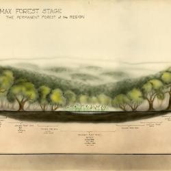
Emergent Plant Series: #6, Climax Forest Stage (3.19490)
Date: 1950sCreator: Watts, May Theilgaard
Type: Drawing
Description:Part of a series of numbered illustrations about the stages of pond growth. This material includes a view of a pond in the center with forest trees and hills in the background, and a cross-section of illustrations of forest trees, and trees and emergent plants of the water's edge.
Header: CLIMAX FOREST STAGE / THE PERMAMENT FOREST of the REGION
Drawings and text from top to bottom, left to right:
- pond and surrounding landscape
- cross-section [divided into 7 sections]:
- CLIMAX FOREST
- red oak
- white oak
- hickory
- LOWLAND FOREST ZONE
- elm
- ash
- hackberry
- linden
- PIONEER TREE ZONE
- willow
- silver maple
- EMERGENT ZONE
- cat-tails
- arrowhead
- bur reed
- pickerel weed
- bull-rush
- PIONEER TREE ZONE
- LOWLAND FOREST ZONE
- CLIMAX FOREST
- CLIMAX FOREST
Extent: 1 sheet

Four Oaks (3.19491)
Date: 1940 – 1959Creator: Watts, May Theilgaard
Type: Drawing
Description:Illustrations of four oaks: Chinkapin oak, Swamp white oak, White oak and Bur oak. Each tree is illustrated by silhouette, and is accompanied by an outline of its leaf and drawings of its twig with a winter bud and its acorn.
upper left: Quercus muehlenbergii, Chinkapin oak
upper right: Quercus bicolor, Swamp white oak
lower left: Quercus alba, White oak
lower right Quercus macrocarpa, Bur oak
Extent: 1 sheet
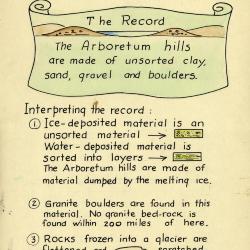
Arboretum Landscape Teaching Aid Series: The Great Ice Sheet (3.19496)
Date: 1940 – 1960Creator: Watts, May Theilgaard
Type: Drawing
Description:Primarily textual teaching aid depicting Arboretum landscape. This material shows how the Arboretum Hills were pushed from Canada and Wisconsin.
Header: THE GREAT ICE SHEET brought THE ARBORETUM HILLS from Canada to Wisconsin
Text and illustrations from top to bottom:
- [Depicted in stylized scroll with an illustration of a body of water between two hills] The Record: The Arboretum hills are made of unsorted clay, sand, gravel and boulders.
- Interpreting the record:
- 1) Ice-deposited material is an unsorted material [arrow pointing right to illustration of ice-deposited material] Water-deposited material is sorted into layers [arrow pointing right to illustration of water-deposited material] The Arboretum hills are made of material dumped by the melting ice.
- 2) Granite boulders are found in this material. No granite bed-rock is found within 200 miles of here.
- 3) Rocks frozen into a glacier are flattened and scratched like this [arrow pointing left to illustration of a rock] (see rock at end of table) Water-borne rocks are rounded and smoothed.
Extent: 1 sheet
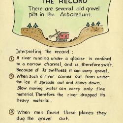
Arboretum Landscape Teaching Aid Series: A River Emerged From Under A Glacier (3.19497)
Date: 1940 – 1960Creator: Watts, May Theilgaard
Type: Drawing
Description:Primarily textual teaching aid depicting Arboretum landscape. This material shows the origin of gravel pits at the Arboretum.
Header: A RIVER EMERGED FROM UNDER A GLACIER
Text and illustrations from top to bottom:
- [Depicted in stylized scroll with illustration of a steam shovel in gravel pit] The Record: There are several old gravel pits in the Arboretum.
- Interpreting the record:
- 1) A river running under a glacier is confined to a narrow channel, and is, therefore swift. Because of its swiftness it can carry gravel.
- 2) When such a river comes out from under the ice it spreads out and slows down. Slow moving water can carry only fine material. Therefore the river dropped its heavy material.
- 3) When men found these places they dug the gravel out.
Extent: 1 sheet
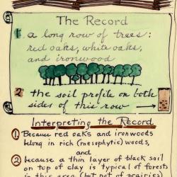
Arboretum Landscape Teaching Aid Series: A Fence Long Gone Marked A Boundary (3.19498)
Date: 1940 – 1960Creator: Watts, May Theilgaard
Type: Drawing
Description:Primarily textual teaching aid depicting Arboretum landscape. This material shows how a fence once marked a boundary through a forest.
Header: A fence (long gone) marked a boundary through a forest (long gone)
Text and illustrations from top to bottom:
- [Depicted in stylized scroll] The Record:
- 1. A long row of trees: red oaks, white oaks, and ironwood [an illustration of a row of trees]
- 2. the soil profile on both sides of this row [arrow pointing right to illustration of a cross-section of soil]
- Interpreting the record:
- 1) Because red oaks and ironwoods belong in rich (mesophytic) woods, and
- 2) because a thin layer of black soil on top of clay is typical of forests in this area (but not of prairies) and
- 3) because there would have been forest-margin trees, like hawthorn, if this fence had edged a forest - We read the record as above [arrow extending upward to header]
Extent: 1 sheet
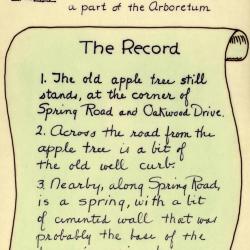
Arboretum Landscape Teaching Aid Series: An Apple Tree was Planted on a Farm (3.19499)
Date: 1940 – 1960Creator: Watts, May Theilgaard
Type: Drawing
Description:Primarily textual teaching aid depicting Arboretum landscape. This material describes the remains of the farm that later became the Arboretum, including an apple tree that still stood at the time.
[Illustration of a farmer with a shovel standing next to a sapling] Header: AN APPLE TREE was planted on a farm, many years ago / The farm later became a part of the Arboretum
Text and illustrations from top to bottom:
- [Depicted in stylized scroll] The Record:
- 1) The old apple tree still stands, at the corner of Spring Road and Oakwood Drive.
- 2) Across the road from the apple tree is a bit of the old well curb.
- 3) Nearby, along Spring Road, is a spring, with a bit of cemented wall that was probably the base of the farmer's spring house. [illustration of a tree]
Extent: 1 sheet
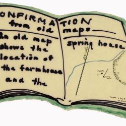
Arboretum Landscape Teaching Aid Series: Confirmation from Old Maps (3.19500)
Date: 1940 – 1960Creator: Watts, May Theilgaard
Type: Drawing
Description:Primarily textual teaching aid depicting Arboretum landscape. This material is depicted in the shape of an open book. It shows a drawing of an old map of the farm that later became the Arboretum.
Header: CONFIRMATION from old maps
Text and illustrations from top to bottom, left to right:
- text: An old map shows the location of the farmhouse and the spring house
- map illustration: a road extending from bottom to top, a stream extending from left to right, trees at top and right, and a small patch of farm land at center with a wall and two structures, one labeled "Solomon Mertz" and the other "Spring house"
- text, bottom right: FROM 1874 ATLAS OF DUPAGE COUNTY
Extent: 1 sheet