A Design for a Water Storage Lake with Controlled Water Release, The Morton Arboretum, Lisle, Illinois (3.5569)
Date: January 1987Creator: Tyznik, Anthony
Type: Plan
Description:"Flood elevation calculations using TR-55 method" served as basis for the development of Crabapple Lake. Lake dimensions and 100-year flood elevations shown by colored shading.
Extent: 1 sheet
A Design for a Water Storage Lake with Controlled Water Release, The Morton Arboretum, Lisle, Illinois (3.5570)
Date: January 1987Creator: Tyznik, Anthony
Type: Plan
Extent: 1 sheet
An atlas of northeastern Illinois (3.5924)
Date: February 1969Creator: Northeast Illinois Planning Commission
Type: Map
Description:"Using a base of the United States Geological Survey flood hazard map quadrangles." Volume contains only quadrangles of the following areas: Elmhurst (HA-68), Hinsdale (HA-86), Lombard (HA-143), Romeoville (HA-146), Sag Bridge (HA-149), Naperville (HA-154), Wheaton (HA-148), West Chicago (HA-202), and Normantown (HA-210).
Extent: 1 volume (loose-leaf)
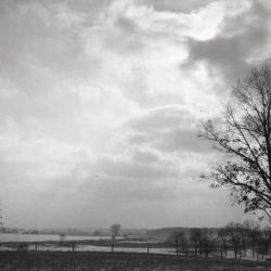
Dr. Malacek's land south of Arboretum during flood (3.33538)
Date: 1960sType: Photographic image
Description:Dr. Malacek's land south of Arboretum during flood
Extent: 1 negative filmstrip
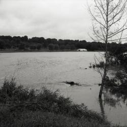
DuPage River valley, spring flooding (3.38264)
Date: 1920sType: Photographic image
Description:DuPage River valley, spring flooding
Extent: 1 negative
East Branch Valley View project area (3.6286)
Date: June 5 1995Creator: Department of Environmental Concerns
Type: Map
Extent: 1 sheet
Floods in Wheaton, Illinois Quadrangle, northeastern Illinois (3.6815)
Date: 1965Creator: May, V. Jeff, Allen, Howard E.
Type: Map
Description:Map shows flooded areas 1954-63. Includes five figures profiling creek floods.
Extent: 1 sheet
Liquidambar styraciflua (sweet-gum), habit, flooding (3.70038)
Date: 2005 – 2012Creator: Hagstrom, John
Type: Photographic image
Description:Liquidambar styraciflua (sweet-gum), habit, tree in very wet area, leaves beginning to turn fall color, highway in background
Lisle, Illinois Township Proposed Zoning (3.5380)
Date: August 1956Creator: DuPage County Board of Supervisors
Type: Map
Description:Flood crest elevations of the Oct.1954 flood are given.
Extent: 1 sheet
Milton Township Proposed Zoning (3.5379)
Date: August 1956Creator: Illinois State Toll Highway Authority
Type: Map
Description:Flood crest elevations of the Oct.1954 flood are given.
Extent: 1 sheet
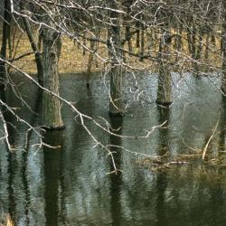
Quercus bicolor (swamp white oak), bare trees in flooded woodland (3.38405)
Type: Photographic image
Description:Quercus bicolor (swamp white oak), bare trees in section of flooded woodland
Extent: 1 slide
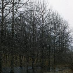
Quercus bicolor (swamp white oak), bare trees in flooded woodland (3.38409)
Type: Photographic image
Description:Quercus bicolor (swamp white oak), bare trees in section of flooded woodland
Extent: 1 slide
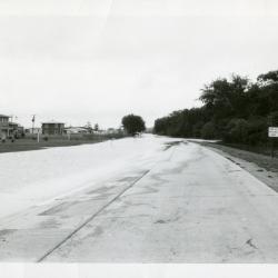
Route 53 north of Park Blvd in flood (3.60071)
Date: 1956 – 1960Type: Photographic image
Description:Route 53 north of Park Blvd in flood
Extent: 1 photograph
The Morton Arboretum [guide map and collections grid, including notes on flooding] (3.6568)
Date: 1982Creator: Coulter, Ronald M.
Type: Map
Description:Approximate limits of DuPage River floodwaters December 3, 1982.
E. Hedborn - December 6, 1982 from field observations of debris and personal observations. Flooding marked in colored marker; ink notes of details.
Extent: 1 sheet
Valley View area, Eagle Lake alternative (3.6287)
Date: July 11 1995Creator: Department of Environmental Concerns
Type: Map
Extent: 1 sheet
[Observations of August 14, 1987 flood levels in Arboretum] (3.6567)
Date: 1987Type: Map
Description:Areas of flooding shown in ink and colored pencil. Aerial photos are sheets 1 and 2. Printed maps are sheets 3-5.
Extent: 5 sheets