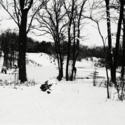
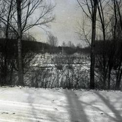
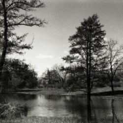
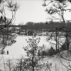
View of Sterling Pond looking north from Clarence Godshalk's yard in winter (3.31809)
Date: 1960sType: Photographic image
Description:View of Sterling Pond looking north from Clarence Godshalk's yard in winter. Open area across Sterling Pond used to be a gravel pit before 1959 when pond was dug.
Extent: 1 negative filmstrip
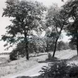
Arboretum unpaved road alongside body of water on left (3.33191)
Date: 1922 – 1949Type: Photographic image
Description:Arboretum unpaved road alongside body of water on left
Extent: 1 negative

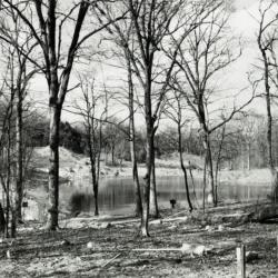
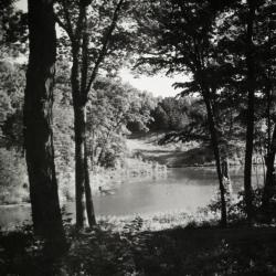
Looking east over Lake Marmo from bottom of Pine Hill (3.34018)
Date: 1922Type: Photographic image
Description:Looking east over Lake Marmo from bottom of Pine Hill
Extent: 1 photograph

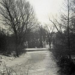
Lake Marmo stream overflow in winter (3.36860)
Date: December 1969Type: Photographic image
Description:Lake Marmo stream overflow in winter
Extent: 1 negative
Lights (3.39930)
Date: November 30 2012Creator: Jacobson, Susan L. B.
Type: Plan
Description:Survey for lights project.
Extent: 1 sheet
Sterling Pond looking north through bare trees from Clarence Godshalk's yard (3.31810)
Date: 1960sType: Photographic image
Description:Sterling Pond looking north through bare trees from Clarence Godshalk's yard. Open area across Sterling Pond used to be a gravel pit before 1959 when pond was dug.
Extent: 1 negative filmstrip
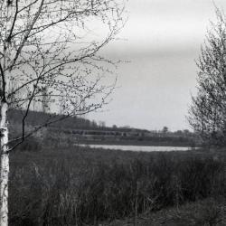
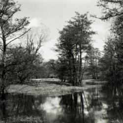
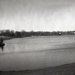
Looking southwest from bridge over DuPage River toward Lake Jopamaca (3.3040)
Date: October 1941Type: Photographic image
Description:Looking southwest from bridge over DuPage River toward Lake Jopamaca
Extent: 1 photograph

Pond west of Sterling Pond Bridge over inlet in winter (3.31811)
Date: 1960sType: Photographic image
Description:Pond west of Sterling Pond Bridge over inlet in winter
Extent: 1 negative filmstrip
Lake Marmo looking north from snow covered road (3.33283)
Type: Photographic image
Description:Lake Marmo looking north from snow covered road
*located at about 14-S on Arboretum map/grid
Extent: 1 negative
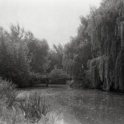
Lake Jopamaca and footbridge, looking east toward DuPage River (3.33982)
Date: 1930 – 1949Type: Photographic image
Description:Lake Jopamaca and footbridge, looking east toward DuPage River
Extent: 1 negative
Existing Noise Contouring Map (3.47257)
Date: April 1999Creator: HDR Engineering, Inc.
Type: Map
Description:Topographical map of the Arboretum grounds in 1999 with noise contour lines and measurements of sound in dB(A).
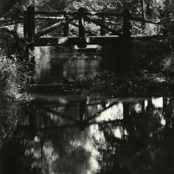
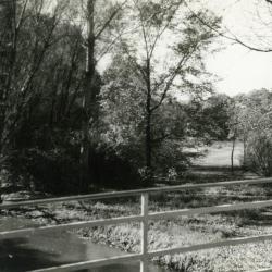
Bridge over Lake Marmo inlet looking upstream (3.3048)
Date: 1940Type: Photographic image
Description:Bridge over Lake Marmo inlet looking upstream
Extent: 1 photograph
Sterling Pond looking north from Clarence Godshalk's yard (3.31812)
Date: 1960sType: Photographic image
Description:Sterling Pond looking north from Director Clarence Godshalk's yard. Open area across Sterling Pond used to be a gravel pit before 1959 when pond was dug.
Extent: 1 negative filmstrip

Lake Marmo looking east in winter (3.33284)
Type: Photographic image
Description:Lake Marmo looking east in winter
*located at about 10-U on Arboretum map/grid
Extent: 1 negative
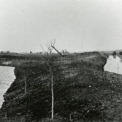
Streambank Stabilization Willoway Creek at The Morton Arboretum DuPage County, Illinois (3.33784)
Date: January 7 1998Creator: Rust Environment & Infrastructure
Type: Plan
Extent: 8 sheets

Acer saccharum (sugar maple), fall color (3.37885)
Date: October 1995Creator: Shouba, Jack
Type: Photographic image
Description:Acer saccharum (sugar maple), large tree situated on the bank of a body of water showing bright orange and golden fall foliage
Extent: 1 slide
Topographic Sketch of Morton Arboretum, Lisle, Illinois (3.5243)
Date: August 1921Creator: O. C. Simonds & Co.
Type: Map
Description:Conceptual oxbow ponds/wetlands along East Branch of the DuPage River are indicated.
Extent: 1 sheet
Sterling Pond looking north (3.31813)
Date: 1960sType: Photographic image
Description:Sterling Pond looking north
Extent: 1 negative filmstrip
South side of Lake Marmo looking west in winter (3.33285)
Type: Photographic image
Description:South side of Lake Marmo looking west in winter
*located at about 14-S on Arboretum map/grid
Extent: 1 negative
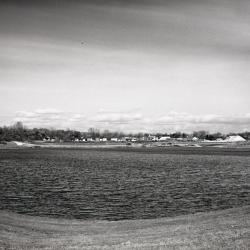
Arbor Lake with Arbordale housing development in background (3.36466)
Date: 1958Type: Photographic image
Description:Arbor Lake with Arbordale housing development in background
Extent: 1 negative
Looking north from Ozarks to European Group (3.38263)
Date: 1920sType: Photographic image
Description:Looking north from Ozarks to European Group
Extent: 1 negative
Topographic Sketch of Morton Arboretum, Lisle, Illinois [handwritten notes] (3.5244)
Date: August 1921Creator: O. C. Simonds & Co.
Type: Map
Description:Native woodland cover is shown by colored shading. Conceptual oxbow ponds/wetlands along East Branch of the DuPage River are indicated. Ms. Note by C.E. Godshalk: "This must have been Mr. Simond's 1st idea…." He has drawn in original Lisle, Illinois Farm buildings.
This copy has notes and markings.
Extent: 1 sheet

Pond on south side of Japanese Island in winter (3.31814)
Date: 1960sType: Photographic image
Description:Pond on south side of Japanese Island in winter
Extent: 1 negative filmstrip

Lake Marmo looking east in winter (3.33286)
Type: Photographic image
Description:Lake Marmo looking east in winter
*located at about 10-U on Arboretum map/grid
Extent: 1 negative
Arbor Lake partially filled with Arbordale houses in background (3.36468)
Date: 1958Type: Photographic image
Description:Arbor Lake partially filled with Arbordale houses in background
Extent: 1 negative

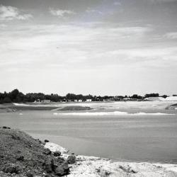
Puffer Lake with Lacy Farm and Arbor Farm in background (3.36989)
Date: 1923 – 1924Type: Photographic image
Description:Puffer Lake
Buildings in center background Alice Lacy Farm. Buildings and silo in right background Arbor Farm, formerly Puffer Farm.
Extent: 1 photograph
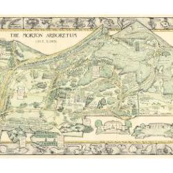
Morton Arboretum Map (3.19479)
Date: 1943Creator: Watts, May Theilgaard
Type: Map
Description:2014 reprint of The Morton Arboretum's first color map, circa 1943.
Detailed map of Arboretum grounds, showing roads, paths, landscaping, shelters, structures, enlargement of some specific features, hedge garden, some specific trees, and trails with markers numbered 1 - 42. Other features include a scale, a calendar, and a compass rose consisting of directions depicted with leaves. A highly ornamental border includes grid marks, as well as drawings of animal tracks and detailed drawings and labels of plants. The Morton Arboretum encompassed 813 acres at time of map.
Extent: 1 sheet

Lake Marmo looking north (3.3056)
Date: 1940sType: Photographic image
Description:Lake Marmo looking north
Extent: 1 negative
Pond on south side of Japanese Island (3.31815)
Date: 1960sType: Photographic image
Description:Pond on south side of Japanese Island
Extent: 1 negative filmstrip

Lake Marmo looking north in winter (3.33287)
Type: Photographic image
Description:Lake Marmo looking north in winter
*located at about 11-T on Arboretum map/grid
Extent: 1 negative

Morton Arboretum Map: Preliminary Drawing for Colored Map (3.19480)
Date: 1943Creator: Watts, May Theilgaard
Type: Drawing
Description:Preliminary drawing for detailed colored map of Arboretum grounds that was printed in 1943, showing roads, paths, landscaping, shelters, enlargement of some specific features, hedge garden, and center of hedge garden. Blank spaces indicate water and text placement. Tree symbols show exceptional specimens on east and west sides. The Morton Arboretum encompassed 813 acres at time of map. Drawing is in two pieces.
Extent: 2 sheets

Morton Arboretum Map (3.19481)
Date: 1943Creator: Watts, May Theilgaard
Type: Map
Description:Detailed map of Arboretum grounds, showing roads, paths, landscaping, shelters, structures, enlargement of some specific features, hedge garden, some specific trees, and trails with markers numbered 1 - 42. Other features include a scale, a calendar, and a compass rose consisting of directions depicted with leaves. A highly ornamental border includes grid marks, as well as drawings of animal tracks and detailed drawings and labels of plants. Some replacement illustration and text has been adhered to the map. The Morton Arboretum encompassed 813 acres at time of map. One section is partially missing.
Extent: 1 sheet
Ozarks first planting alongside nearly constructed Lake Jopamaca, DuPage River to the right (3.3070)
Date: March 21 – June 20 1922Type: Photographic image
Description:Looking north at Ozarks first planting alongside nearly constructed Lake Jopamaca, DuPage River to the right
Extent: 1 photograph
Looking south over Sterling Pond in winter (3.31779)
Date: February 1970Type: Photographic image
Description:Looking south over Sterling Pond in winter
Extent: 1 negative
Arbor Lake with staff houses in background (3.31780)
Date: 1959Type: Photographic image
Description:Arbor Lake with staff houses in background
Extent: 1 negative
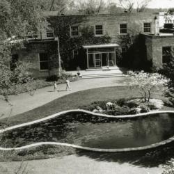
Administration Building front entrance and lily pond, aerial view (3.3769)
Type: Photographic image
Description:Administration Building front entrance and lily pond, aerial view
Extent: 1 photograph