Browsing by Subject/Keyword: object type:
Topographic Sketch of Morton Arboretum, Lisle, Illinois [handwritten notes] (3.5244)
Date: August 1921Creator: O. C. Simonds & Co.
Type: Map
Description:Native woodland cover is shown by colored shading. Conceptual oxbow ponds/wetlands along East Branch of the DuPage River are indicated. Ms. Note by C.E. Godshalk: "This must have been Mr. Simond's 1st idea…." He has drawn in original Lisle, Illinois Farm buildings.
This copy has notes and markings.
Extent: 1 sheet
Topographic Sketch of Morton Arboretum, Lisle, Illinois (3.5243)
Date: August 1921Creator: O. C. Simonds & Co.
Type: Map
Description:Conceptual oxbow ponds/wetlands along East Branch of the DuPage River are indicated.
Extent: 1 sheet

General Information and Guide Map of The Morton Arboretum (3.34267)
Date: 1941Type: Map
Description:Doublesided brochure with general information and a guide map of The Morton Arboretum.
Guide map details Arboretum roads, trails, parking, plant collections, buildings and points of interest. Fifteen areas on the grounds highlighted in the key and identified with circled numbers on the map. Surfaced roads, gravel roads, and paths distinguished on the map by the type of line drawn. Compass showing directions north, south, east, west as well as scale indicator above top center of map.
Reverse side provides general information about the Arboretum, rules and regulations, and information about the Arboretum publication, Bulletin of Popular Information.
Extent: 1 sheet

General Information and Guide Map of The Morton Arboretum (3.34268)
Date: 1942Type: Map
Description:Doublesided brochure with general information and a guide map of The Morton Arboretum.
Guide map details Arboretum roads, trails, parking, plant collections, buildings and points of interest. Vegetation illustrated throughout map. Three stylized trees under compass showing directions north, south, east, west as well as scale indicator above top center of map.
Reverse side provides general information about the Arboretum, rules and regulations, outstanding features, buildings, Arboretum publications, and location.
Extent: 1 sheet
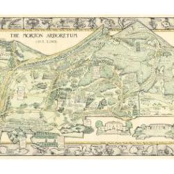
Morton Arboretum Map (3.19479)
Date: 1943Creator: Watts, May Theilgaard
Type: Map
Description:2014 reprint of The Morton Arboretum's first color map, circa 1943.
Detailed map of Arboretum grounds, showing roads, paths, landscaping, shelters, structures, enlargement of some specific features, hedge garden, some specific trees, and trails with markers numbered 1 - 42. Other features include a scale, a calendar, and a compass rose consisting of directions depicted with leaves. A highly ornamental border includes grid marks, as well as drawings of animal tracks and detailed drawings and labels of plants. The Morton Arboretum encompassed 813 acres at time of map.
Extent: 1 sheet

Morton Arboretum Map (3.19481)
Date: 1943Creator: Watts, May Theilgaard
Type: Map
Description:Detailed map of Arboretum grounds, showing roads, paths, landscaping, shelters, structures, enlargement of some specific features, hedge garden, some specific trees, and trails with markers numbered 1 - 42. Other features include a scale, a calendar, and a compass rose consisting of directions depicted with leaves. A highly ornamental border includes grid marks, as well as drawings of animal tracks and detailed drawings and labels of plants. Some replacement illustration and text has been adhered to the map. The Morton Arboretum encompassed 813 acres at time of map. One section is partially missing.
Extent: 1 sheet
Morton Arboretum [Aerial Photograph and] Conservation Plan Map, Kane-DuPage Soil Conservation District. (3.5416)
Date: June 1964Creator: U.S. Soil Conservation Service
Type: Map
Description:Photomosaic produced from aerial photographs believed to have been taken in the 1940s. "Photo nos. BWS-8N-11, 8N-12, 8N-13, 4N-63, 4N-64, 4N-65, 4N-66, &4N-67." The photograph has been marked in ink with water features and major highways.
Extent: 1 sheet

A Guide Map of The Morton Arboretum (3.34269)
Date: 1969Creator: Tyznik, Anthony
Type: Map
Description:A guide map of The Morton Arboretum created by Tony Tyznik in 1969. The background is a dark green with the inner Arboretum being a light green and Arboretum roads highlighted in solid orange and checkered orange lines.
Extent: 1 sheet

Map & Visitor Guide, The Morton Arboretum (3.34271)
Date: 1982 – 1986Type: Map
Description:Double-sided brochure, Map & Visitor Guide for The Morton Arboretum
Map details Arboretum roads, trails, plant collections, buildings and boundaries. Includes photographs of various Arboretum buildings with descriptive information.
Reverse side provides general information about the Arboretum, trails for walking and hiking, driving through the Arboretum, areas and collections of special interest, native plant communities, wildlife at the Arboretum, regulations, facilities and services, and information on membership. A section of the map is enlarged to identify landmarks around the Visitor Center, Administration Building, and Thornhill Education Center.
Extent: 1 sheet
The Morton Arboretum Inventory & Collections & Cultural Names (3.44609)
Date: April 25 1990Creator: Sidwell Company
Type: Map
Description:Four topographical maps with drawn area boundaries and area names written in marker. Page 5 is missing.
Extent: 4 Sheets
Map of Natural Area Management Types (3.44607)
Date: March 26 1992Creator: Butkovich, Dianne
Type: Map
Description:Printed topographical map with hand-drawn lines and hand-numbered regions.
Attached Key includes notes on natural area types, restoration areas, and restoration techniques.
Extent: 1 Sheet
Existing Noise Contouring Map (3.47257)
Date: April 1999Creator: HDR Engineering, Inc.
Type: Map
Description:Topographical map of the Arboretum grounds in 1999 with noise contour lines and measurements of sound in dB(A).
Lake Marmo Visitor Station Survey Worksheet (3.44608)
Date: May 5 1999Type: Map
Description:Topographic map of Lake Marmo and Visitor Station with elevation bench marks.
Extent: 1 Sheet
Morton Arboretum Willoway Brook tributary stream enhancement project, phase II, DuPage County, Illinois (3.31598)
Date: March 28 2005Type: Map
Description:Thomas Burke, Jr.
Extent: 11 sheets bound
Aerial Image of Arboretum Grounds (3.47230)
Date: December 2007Creator: Pelkonen, Peggy
Type: Map
Description:Aerial image of Arboretum grounds in 2007 with handwritten notes and circled regions showing detention basins.
Black and white with some color.
Extent: 1 Sheet