Lunching & Learning with Clarence Godshalk: Evolution of the Arboretum - From Farm to Arboretum (3.31582)
Date: January 25 1978Type: Audio
Description:Lunching and Learning program presented by Clarence Godshalk as he describes the evolution of the Arboretum, from farm land to Arboretum.
Extent: 1 audio cassette
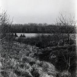
Puffer Lake looking north (3.31783)
Date: 1920sType: Photographic image
Description:Puffer Lake looking north
Extent: 1 negative
Path near Puffer Lake looking south (3.31784)
Date: 1930sType: Photographic image
Description:Path near Puffer Lake looking south
Extent: 1 negative
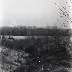
Landscape along path near Puffer Lake looking south (3.31785)
Date: 1930sType: Photographic image
Description:Landscape along path near Puffer Lake looking south
Extent: 1 negative

Puffer Lake with heron looking right (3.31904)
Date: 1930 – 1949Type: Photographic image
Description:Puffer Lake with heron looking right
Extent: 1 negative

Puffer Lake with heron looking left (3.31905)
Date: 1930 – 1949Type: Photographic image
Description:Puffer Lake with heron looking left
Extent: 1 negative

Snow covered planting lane near Puffer Lake (3.31906)
Date: January 1972Type: Photographic image
Description:Snow covered planting lane near Puffer Lake
Extent: 1 negative

Shrub Collection near Puffer Lake with intersecting power lines (3.31907)
Date: January 1972Type: Photographic image
Description:Shrub Collection near Puffer Lake with intersecting power lines
Extent: 1 negative

Larch trees camouflaging power towers near Puffer Lake (3.31909)
Date: January 1972Type: Photographic image
Description:Early plantings of larch near Puffer Lake help camouflage power towers. Rare Kentucky coffee-tree appears in the upper portion of the photo.
Extent: 1 negative

Puffer Lake with cattails in foreground (3.31910)
Date: January 1972Type: Photographic image
Description:Puffer Lake Bird Sanctuary retains some of its birds, cattails, and water, but power lines dominate the scenery.
Extent: 1 negative

Looking north across snow covered Puffer Lake (3.31911)
Date: January 1972Type: Photographic image
Description:Looking north across Puffer Lake from the former site of the bird observatory.
Extent: 1 negative

Snow covered lane between Puffer Lake and the Arboretum boundary (3.31912)
Date: January 1972Type: Photographic image
Description:Lanes between Puffer Lake and the Arboretum boundary benefit from wildlife plantings set out in the early 1940's.
Extent: 1 negative

View of shrub collection through bur oaks near Puffer Lake (3.31913)
Date: January 1972Type: Photographic image
Description:Where vegetation under bur oaks has been removed, it is possible to see the eastern portion of the Arboretum shrub collection in the distance - near Puffer Lake
Extent: 1 negative

View of shrub collection near Puffer Lake (3.31914)
Date: January 1972Type: Photographic image
Description:A close-up view of a small portion of the gridded Arboretum shrub collection. Note extensive maintenance required - located near Puffer Lake
Extent: 1 negative

Puffer Lake southern boundary (3.31915)
Date: January 1972Type: Photographic image
Description:View of the southern boundary of Puffer Lake. Willows and cattails are all that remain of the richer flora visible last summer.
Extent: 1 negative

Old hawthorn tree near Puffer Lake (3.31916)
Date: January 1972Type: Photographic image
Description:This old hawthorn tree and other unique specimens are to be found along the proposed FA-61 right-of-way - near Puffer Lake
Extent: 1 negative

Pheasant and rabbit footprints along planted lane near Puffer Lake (3.31917)
Date: January 1972Type: Photographic image
Description:Pheasants and rabbits use the planted lanes extensively, as this photo taken January, 1972 indicates - near Puffer Lake
Extent: 1 negative

View of street tree collection near Puffer Lake (3.31918)
Date: January 1972Type: Photographic image
Description:The valuable street tree collection now reaching useful size. While not included in the projected FA-61 right-of-way, it is close enough to be affected as leaf damage in the fall of 1971 indicated. - near Puffer Lake
Extent: 1 negative

Close-up view of experimental pollutant collection equipment near Puffer Lake (3.31919)
Date: January 1972Type: Photographic image
Description:Close-up view of experimental pollutant collection equipment near Puffer Lake
Extent: 1 negative

Grove of bur oak trees near Puffer Lake (3.31920)
Date: January 1972Type: Photographic image
Description:A grove of old bur oak trees preserves original soil and water relationships near Puffer Lake. Heavy vegetation beneath provides impenetrable wildlife retreat. The hill would be destroyed by FA-61 construction.
Extent: 1 negative

Looking south from Puffer Lake inlet across the East-West Tollway with office building in background (3.31921)
Date: January 1972Type: Photographic image
Description:Looking south from Puffer Lake inlet across the East-West Tollway with office building in background. Water is sifted, filtered, treated and stored in a natural swamp-marsh-lake sequence, helping preserve the quality and quantity of DuPage County water.
Extent: 1 negative

Experimental devices to catch salt from East-West Tollway near Puffer Lake (3.31922)
Date: January 1972Type: Photographic image
Description:Arboretum scientists have installed experimental devices at intervals to catch salt and other fallout at various distances from the East-West Tollway near Puffer Lake.
Extent: 1 negative

Snow-covered planting lane near Puffer Lake with bare trees along side (3.31923)
Date: January 1972Type: Photographic image
Description:Snow-covered planting lane near Puffer Lake with bare trees along side.
Extent: 1 negative

Cattails in winter near Puffer Lake (3.31924)
Date: January 1972Type: Photographic image
Description:Cattails in winter near Puffer Lake
Extent: 1 negative

A Guide Map of The Morton Arboretum (3.34269)
Date: 1969Creator: Tyznik, Anthony
Type: Map
Description:A guide map of The Morton Arboretum created by Tony Tyznik in 1969. The background is a dark green with the inner Arboretum being a light green and Arboretum roads highlighted in solid orange and checkered orange lines.
Extent: 1 sheet

Map & Visitor Guide, The Morton Arboretum (3.34271)
Date: 1982 – 1986Type: Map
Description:Double-sided brochure, Map & Visitor Guide for The Morton Arboretum
Map details Arboretum roads, trails, plant collections, buildings and boundaries. Includes photographs of various Arboretum buildings with descriptive information.
Reverse side provides general information about the Arboretum, trails for walking and hiking, driving through the Arboretum, areas and collections of special interest, native plant communities, wildlife at the Arboretum, regulations, facilities and services, and information on membership. A section of the map is enlarged to identify landmarks around the Visitor Center, Administration Building, and Thornhill Education Center.
Extent: 1 sheet

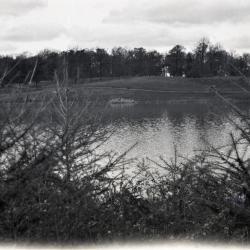
Puffer Lake with Lacy Farm and Arbor Farm in background (3.36989)
Date: 1923 – 1924Type: Photographic image
Description:Puffer Lake
Buildings in center background Alice Lacy Farm. Buildings and silo in right background Arbor Farm, formerly Puffer Farm.
Extent: 1 photograph