
From the Archives: Discovering Thornhill (3.10996)
Date: December 21 1989 – March 20 1990Creator: Doty, Carol L.
Type: Article
Lunching & Learning with Clarence Godshalk: Evolution of the Arboretum - From Farm to Arboretum (3.31582)
Date: January 25 1978Type: Audio
Description:Lunching and Learning program presented by Clarence Godshalk as he describes the evolution of the Arboretum, from farm land to Arboretum.
Extent: 1 audio cassette

General Information and Guide Map of The Morton Arboretum (3.34267)
Date: 1941Type: Map
Description:Doublesided brochure with general information and a guide map of The Morton Arboretum.
Guide map details Arboretum roads, trails, parking, plant collections, buildings and points of interest. Fifteen areas on the grounds highlighted in the key and identified with circled numbers on the map. Surfaced roads, gravel roads, and paths distinguished on the map by the type of line drawn. Compass showing directions north, south, east, west as well as scale indicator above top center of map.
Reverse side provides general information about the Arboretum, rules and regulations, and information about the Arboretum publication, Bulletin of Popular Information.
Extent: 1 sheet
The Morton Arboretum Quarterly V. 04 No. 04 (3.34565)
Date: December 21 1968 – March 20 1969Type: Serial
Description:
- The Arboretum Landscape – A Sesquicentennial Perspective (49-61)
- Blue Beech, Carpinus caroliniana: Birch Family (Betulaceae) (62-63)
- The Lookout/ Climatological Summary (64)
Extent: 16 pages
The Morton Arboretum Quarterly V. 05 No. 04 (3.34569)
Date: December 21 1969 – March 20 1970Type: Serial
Description:
- The Morton Arboretum: planning for its Second Half-Century (49-53)
- River Birch, Betula nigra: Birch Family (Betulaceae) (54-55)
- The River and the Watershed (56-64)
- Climatological Summary (64)
Extent: 16 pages
Tract Map of The Morton Arboretum 1982 Sheet 2 (3.36143)
Date: March 8 1972Creator: Steinbrecher, Harold F.
Type: Map
Description:Dated March 8, 1972. Revised on November 29, 1979. Surroundings updated on May 25, 1982.
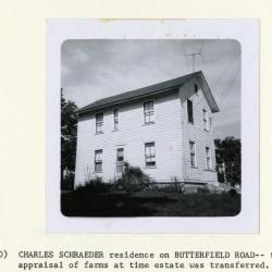
Charles Schroeder residence on Butterfield Road, taken for appraisal of farms at time estate was transferred (3.38238)
Date: 1940sType: Photographic image
Description:Charles Schroeder residence on Butterfield Road, taken for appraisal of farms at time estate was transferred
Extent: 1 photograph
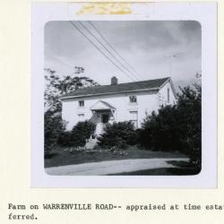
Farm on Warrenville Road, appraised at time estate was transferred (3.38239)
Date: 1940sType: Photographic image
Description:Farm on Warrenville Road, appraised at time estate was transferred
Extent: 1 photograph
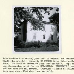
Farm residence on Ogden, formerly Ed Puffer farm, later called Arbor Farm (3.38240)
Date: 1940sType: Photographic image
Description:Farm residence on Ogden, just east of Belmont and Warrenville Roads (north side), formerly Ed Puffer farm, later called Arbor Farm. Entrance to Arboretum from this property. Kept hogs. Pond was observation point for the Holabirds. Eickhorsts lived there and ran farm for Mr. Morton. (Rudolph Eickhorst, father of Walter Eickhorst). House torn down about 1946 when land was sold.
Extent: 1 photograph
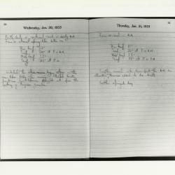
Pages from Lowell Kammerer's Collection Daily Reminder Diaries, Jan. 30-31, 1935 (3.4490)
Type: Photographic image
Description:Pages from Lowell Kammerer's Collection Daily Reminder Diaries, Jan. 30-31, 1935
Includes weather notations and notes about the grounds
Extent: 1 photograph
Morton Arboretum [development and land acquisitions] (3.5288)
Date: 1920sType: Map
Description:A schematic drawing showing principal land tracts and ownership within the projected boundaries of the Arboretum.
Extent: 1 sheet
Plat of the SE 1/4 Section 35, T.39N., and NE 1/4 Section 2, T.38N., R.10E of the 3rd P.M..[and] Plat of the S 1/2 Section 36, T.39N., N1/2 Section 1, T.38N., Range 10E of the 3rd P.M. (3.5292)
Date: July 1921Creator: Webster, Arthur L.
Type: Map
Description:Original map comprises two sheets, separately produced and titled, which have been joined without cropping an overlapping area. This composite version with the overlap omitted was subsequently made by C.E. Godshalk, with all other descriptions of the original reproduced. Both versions of this work are represented in the collections. The area surveyed is located in the southeast corner of the Arboretum. Original land owners and acreages of their tracts are given. This copy has shaded areas that show land Mr. Morton did not own in 1921.
CEG copy
Extent: 1 sheet
Map Showing the Morton Arboretum and the Adjoining Lands Owned by the Joy Morton Estate in DuPage County, Illinois, Compiled from Surveys and Deed Records (3.5347)
Date: September 1 1940Creator: Steinbrecher, Harold F.
Type: Map
Description:Map shows ms. annotations by C.E. Godshalk giving acreages as of March 21, 1965 and notes on purchases and sales of some land areas. A portion of the estate lies outside of the Arboretum boundaries. Collection has one copy showing various woodlands and buildings in colored shading added by Godshalk in the late 1950's; the Commonwealth Edison and Tollway rights-of-way are indicated.
Extent: 1 sheet
Map Showing the Morton Arboretum and the Adjoining Lands Owned by the Joy Morton Estate in DuPage County, Illinois, Compiled from Surveys and Deed Records (3.5348)
Date: September 1 1940Creator: Steinbrecher, Harold F.
Type: Map
Description:Map shows ms. annotations by C.E. Godshalk giving acreages as of March 21, 1965 and notes on purchases and sales of some land areas. A portion of the estate lies outside of the Arboretum boundaries. Collection has one copy showing various woodlands and buildings in colored shading added by Godshalk in the late 1950's; the Commonwealth Edison and Tollway rights-of-way are indicated.
Extent: 1 sheet
Plat of Survey of Part of Section 36, Township 39 North, Range 10 East of the Third Principal Meridian in DuPage, County, Illinois (3.5363)
Date: June 14 1954Creator: Steinbrecher, Harold F.
Type: Map
Description:Property originally owned by the Johnson Estate and acquired by the Arboretum as the Sunny Acres purchase.
Extent: 1 sheet
A complied tract map of the Morton Arboretum, being parts of Sections 33, 34, 35, and 36, township 39 North, Range 10 East of the 3rd Principal Meridian, and parts of Sections 1, 2, 3, and 4,, township 38 North, Range 10 East of the third Principal Meridian in DuPage County, Illinois. [1982 ed.] (3.5405)
Date: May 25 1982Creator: Steinbrecher, Harold F.
Type: Map
Description:First issued in 1 sheet version Nov. 22, 1971. A revision was issued March 7, 1972 in 2 sheets: Map on sheet 1 and narrative table on sheet 2. The map on sheet 1 was upgraded with scale readings in a version dated July 5, 1972. A second revision was issued Nov. 29, 1979. This version of the map was updated on May 25, 1982. All issuances, 1971-1982, are represented in the collections.
Sheet 1 shows plats throughout the Arboretum; and sheet 2, a tabular layout, identifies 40 tracts keyed numerically to areas shown on the map. Data supplied for tracts include name, location, prior ownership, previous land usage, acreage, and date of plat surveys.
Extent: 2 sheets
A complied tract map of the Morton Arboretum, being parts of Sections 33, 34, 35, and 36, township 39 North, Range 10 East of the 3rd Principal Meridian, and parts of Sections 1, 2, 3, and 4,, township 38 North, Range 10 East of the third Principal Meridian in DuPage County, Illinois. [1979 ed.] (3.5408)
Date: November 29 1979Creator: Steinbrecher, Harold F.
Type: Map
Description:First issued in 1 sheet version Nov. 22, 1971. A revision was issued March 7, 1972 in 2 sheets:Map on sheet 1 and narrative table on sheet 2. The map on sheet 1 was upgraded with scale readings in a version dated July 5, 1972. This map is the second revision, which was issued Nov. 29, 1979. All issuances, 1971-1982, are represented in the collections.
Sheet 1 shows plats throughout the Arboretum; and sheet 2, a tabular layout, identifies 40 tracts keyed numerically to areas shown on the map. Data supplied for tracts include name, location, prior ownership, previous land usage, acreage, and date of plat surveys.
Extent: 2 sheets
A complied tract map of the Morton Arboretum, being parts of Sections 33, 34, 35, and 36, township 39 North, Range 10 East of the 3rd Principal Meridian, and parts of Sections 1, 2, 3, and 4,, township 38 North, Range 10 East of the third Principal Meridian in DuPage County, Illinois. [1972 ed.] (3.5409)
Date: March 7 1972Creator: Steinbrecher, Harold F.
Type: Map
Description:First issued in 1 sheet version Nov. 22, 1971. This map is a revision, which was issued March 7, 1972 in 2 sheets: Map on sheet 1 and narrative table on sheet 2. The map on sheet 1 was upgraded with scale readings in a version dated July 5, 1972. A second revision was issued Nov. 29, 1979. All issuances, 1971-1982, are represented in the collections.
Sheet 1 shows plats throughout the Arboretum; and sheet 2, a tabular layout, identifies 40 tracts keyed numerically to areas shown on the map. Data supplied for tracts include name, location, prior ownership, previous land usage, acreage, and date of plat surveys.
Extent: 2 sheets
A complied tract map of the Morton Arboretum, being parts of Sections 33, 34, 35, and 36, township 39 North, Range 10 East of the 3rd Principal Meridian, and parts of Sections 1, 2, 3, and 4,, township 38 North, Range 10 East of the third Principal Meridian in DuPage County, Illinois. [1971 ed.] (3.5410)
Date: November 22 1971Creator: Steinbrecher, Harold F.
Type: Map
Description:This map is the first version which was issued as 1 sheet Nov. 22, 1971. A revision was issued March 7, 1972 in 2 sheets: Map on sheet 1 and narrative table on sheet 2. The map on sheet 1 was upgraded with scale readings in a version dated July 5, 1972. A second revision was issued Nov. 29, 1979. All issuances, 1971-1982, are represented in the collections.
Sheet 1 shows plats throughout the Arboretum; and sheet 2, a tabular layout, identifies 40 tracts keyed numerically to areas shown on the map. Data supplied for tracts include name, location, prior ownership, previous land usage, acreage, and date of plat surveys.
Extent: 1 sheet
Hidden Lake Forest Preserve, Exhibit 1: Arboretum-Forest Preserve District Cooperative Research Program Space Study (3.5411)
Date: April 23 1985Creator: Forest Preserve District of DuPage County
Type: Map
Description:Shows boundaries and acreage in the eastern half of the Arboretum made available to the Arboretum by the Forest Preserve District, and others made available to the Forest Preserve District by the Arboretum.
Topography is shown.
Mounted.
Extent: 1 sheet mounted
Map Showing the Morton Arboretum and the Adjoining Lands Owned by the Joy Morton Estate in DuPage County, Illinois, Compiled from Surveys and Deed Records (3.5707)
Date: September 1 1940Creator: Steinbrecher, Harold F.
Type: Map
Description:This copy shows various woodlands and buildings in colored shading added by Godshalk in the late 1950s. Collection includes maps showing ms. annotations by C.E. Godshalk giving acreages as of March 21, 1965 and notes on purchases and sales of some land areas.
The Commonwealth Edison and Tollway rights-of-way are indicated. A portion of the estate lies outside of the Arboretum boundaries.
Extent: 1 sheet
Proposed future Morton Arboretum space development: needs and their suggested relationships [colored] (3.5742)
Date: 1970sCreator: Tyznik, Anthony
Type: Plan
Description:Based on the map prepared by Nancy Hart Stieber, Morton Arboretum map [proposed land use 1969]. This version is colored in marker.
Extent: 1 sheet
Proposed future Morton Arboretum space development: needs and their suggested relationships (3.5743)
Date: 1970sCreator: Tyznik, Anthony
Type: Plan
Description:Based on the map prepared by Nancy Hart Stieber, Morton Arboretum map [proposed land use 1969].
Extent: 1 sheet
Lisle Twp.[portion of] Sec. 1, 2, 3 [and] 4, T. 38N., R. 10E. of the 3rd P. M. (3.5844)
Date: 1960sCreator: DuPage County
Type: Map
Description:Presumably copies made from DuPage County plat maps. Dates for various revisions are added in ms. Shows names of many property owners and prices of various land tracts. For Section 1 the following quarter sections are covered: the SW, the NW, and the NE; for Section 2: the NW and NE; for Section 3: the NW and the NE; and for Section 4: the NE only.
Extent: 8 sheets
[Plat map of Milton Township, DuPage County, Illinois] (3.5892)
Date: 1910sCreator: DuPage County
Type: Map
Description:Initial land purchases in Milton Township made by Joy and Mark Morton are drawn in ms.
Extent: 1 sheet (wall map on wooden rollers)
Township map; south portion Milton and north portion Lisle, DuPage County, Illinois (3.5893)
Date: April 1912Creator: DuPage County
Type: Map
Extent: 1 sheet
Township map; south portion Milton and north portion Lisle, DuPage County, Illinois (3.5894)
Date: April 1912Creator: DuPage County
Type: Map
Extent: 1 sheet
Township map; south portion Milton and north portion Lisle, DuPage County, Illinois (3.5895)
Date: April 1912Creator: DuPage County
Type: Map
Extent: 1 sheet
Plat of the SE 1/4 Section 35, T.39N., and NE 1/4 Section 2, T.38N., R.10E of the 3rd P.M. [and] Plat of the S 1/2 Section 36, T.39N., N1/2 Section.1, T.38N., Range 10E of the 3rd P.M. (3.5978)
Date: July 1921Creator: Webster, Arthur L.
Type: Map
Description:Original map comprises two sheets, separately produced and titled, which have been joined without cropping an overlapping area. This composite version with the overlap omitted was subsequently made by C.E. Godshalk, with all other descriptions of the original reproduced. Both versions of this work are represented in the collections. The area surveyed is located in the southeast corner of the Arboretum. Original land owners ans acreages of their tracts are given.
Sealed CEG copy; has ms notes recording deeded dates, etc.
Extent: 1 sheet
Township map: south portion Milton and north portion Lisle, DuPage County, Illinois (3.5985)
Date: April 1912Creator: DuPage County
Type: Map
Extent: 1 sheet
Township map: south portion Milton and north portion Lisle, DuPage County, Illinois (3.5986)
Date: April 1912Creator: DuPage County
Type: Map
Extent: 1 sheet
Joy Morton DuPage County properties numbered according to date of purchase (3.5990)
Date: August 1934Creator: Kammerer, E. Lowell
Type: Map
Description:Ink drawing with parcels shaded with colored pencil.
Extent: 1 sheet
A Guide Map of The Morton Arboretum, Lisle, Illinois [1958? with written notes regarding land purchases and use] (3.5997)
Date: circa 1958Creator: Tyznik, Anthony
Type: Map
Description:Probably prepared for collateral use in the Arboretum's informal series titled: Map & Visitor Guide.
Includes misc notes by C.E. Godshalk regarding land purchases and use.
Extent: 1 sheet
Hidden Lake Forest Preserve [Exhibit 1: Arboretum-Forest Preserve District Cooperative Research Program Space Study] (3.6090)
Date: April 1984Creator: Forest Preserve District of DuPage County
Type: Map
Description:Shows boundaries and acreage in the eastern half of the Arboretum made available to the Arboretum by the Forest Preserve District, and others made available to the Forest Preserve District by the Arboretum. Topography is shown. Copy 2 is a diazotype aerial photo with topographic lines dated April 1984.
Extent: 1 sheet
A complied tract map of the Morton Arboretum, being parts of Sections 33, 34, 35, and 36, township 39 North, Range 10 East of the 3rd Principal Meridian, and parts of Sections 1, 2, 3, and 4,, township 38 North, Range 10 East of the third Principal Meridian in DuPage County, Illinois. [1982 ed. with parcel numbers] (3.6117)
Date: May 25 1982Creator: Steinbrecher, Harold F.
Type: Map
Description:First issued in 1 sheet version Nov. 22, 1971. A revision was issued March 7, 1972 in 2 sheets: Map on sheet 1 and narrative table on sheet 2. The map on sheet 1 was upgraded with scale readings in a version dated July 5, 1972. A second revision was issued Nov. 29, 1979. This version of the map was updated on May 25, 1982. All issuances, 1971-1982, are represented in the collections.
Sheet 1 shows plats throughout the Arboretum; and sheet 2, a tabular layout, identifies 40 tracts keyed numerically to areas shown on the map. Data supplied for tracts include name, location, prior ownership, previous land usage, acreage, and date of plat surveys.
This version of the map includes parcel numbers written in red pencil.
Extent: 2 sheets
Proposed future Morton Arboretum space development: needs and their suggested relationships [Jan. 12, 1983 revision: including Research Building and additional gardens along Joy Path] (3.6157)
Date: January 12 1983Creator: Tyznik, Anthony
Type: Map
Description:Based on the map prepared by Nancy Hart Stieber, Morton Arboretum map [proposed land use 1969]. This version includes additional notations for Research Building and additional gardens along Joy Path.
Extent: 1 sheet