Browsing by decade: object type:
Yellow Variegated Sweet Gum (3.18635)
Date: 1964Creator: Kammerer, E. Lowell, Chirpe, Rodney.
Type: Drawing
Ginkgo, Maidenhair Tree (3.18644)
Date: 1964Creator: Kammerer, E. Lowell, Chirpe, Rodney.
Type: Drawing

Vernal Witch-hazel (3.19477)
Date: 1940 – 1960Creator: Watts, May Theilgaard
Type: Drawing
Description:Illustration of the Vernal witch-hazel plant, including three detailed views and some descriptive text. Background sketches include trees at top and center, and shrubs at center and bottom.
Header: VERNAL WITCH-HAZEL, HAMAMELIS vernalis
Illustrations as depicted, from top to bottom, left to right:
- a single pistil, labeled PISTIL
- two stamens, front view and side view, labeled STAMEN
- a single twig in bloom
- a flower
Extent: 1 sheet

Skunk Cabbage (3.19478)
Date: 1940 – 1960Creator: Watts, May Theilgaard
Type: Drawing
Description:Illustration of the skunk cabbage plant with environment, including three detailed views of flowering parts. Background sketches include a willow tree, cattails, and skunk cabbage in and near water.
Header: SKUNK CABBAGE
Illustrations as depicted, from top to bottom, left to right:
- enlarged view of the spathe
- enlarge view of a single flower
- enlarged view of the spadix
Extent: 1 sheet
Arboretum Landscape Teaching Aid Series: The Great Ice Sheet (3.19496)
Date: 1940 – 1960Creator: Watts, May Theilgaard
Type: Drawing
Description:Primarily textual teaching aid depicting Arboretum landscape. This material shows how the Arboretum Hills were pushed from Canada and Wisconsin.
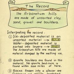
Header: THE GREAT ICE SHEET brought THE ARBORETUM HILLS from Canada to Wisconsin
Text and illustrations from top to bottom:
- [Depicted in stylized scroll with an illustration of a body of water between two hills] The Record: The Arboretum hills are made of unsorted clay, sand, gravel and boulders.
- Interpreting the record:
- 1) Ice-deposited material is an unsorted material [arrow pointing right to illustration of ice-deposited material] Water-deposited material is sorted into layers [arrow pointing right to illustration of water-deposited material] The Arboretum hills are made of material dumped by the melting ice.
- 2) Granite boulders are found in this material. No granite bed-rock is found within 200 miles of here.
- 3) Rocks frozen into a glacier are flattened and scratched like this [arrow pointing left to illustration of a rock] (see rock at end of table) Water-borne rocks are rounded and smoothed.
Extent: 1 sheet
Arboretum Landscape Teaching Aid Series: A River Emerged From Under A Glacier (3.19497)
Date: 1940 – 1960Creator: Watts, May Theilgaard
Type: Drawing
Description:Primarily textual teaching aid depicting Arboretum landscape. This material shows the origin of gravel pits at the Arboretum.
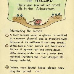
Header: A RIVER EMERGED FROM UNDER A GLACIER
Text and illustrations from top to bottom:
- [Depicted in stylized scroll with illustration of a steam shovel in gravel pit] The Record: There are several old gravel pits in the Arboretum.
- Interpreting the record:
- 1) A river running under a glacier is confined to a narrow channel, and is, therefore swift. Because of its swiftness it can carry gravel.
- 2) When such a river comes out from under the ice it spreads out and slows down. Slow moving water can carry only fine material. Therefore the river dropped its heavy material.
- 3) When men found these places they dug the gravel out.
Extent: 1 sheet
Arboretum Landscape Teaching Aid Series: A Fence Long Gone Marked A Boundary (3.19498)
Date: 1940 – 1960Creator: Watts, May Theilgaard
Type: Drawing
Description:Primarily textual teaching aid depicting Arboretum landscape. This material shows how a fence once marked a boundary through a forest.
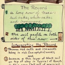
Header: A fence (long gone) marked a boundary through a forest (long gone)
Text and illustrations from top to bottom:
- [Depicted in stylized scroll] The Record:
- 1. A long row of trees: red oaks, white oaks, and ironwood [an illustration of a row of trees]
- 2. the soil profile on both sides of this row [arrow pointing right to illustration of a cross-section of soil]
- Interpreting the record:
- 1) Because red oaks and ironwoods belong in rich (mesophytic) woods, and
- 2) because a thin layer of black soil on top of clay is typical of forests in this area (but not of prairies) and
- 3) because there would have been forest-margin trees, like hawthorn, if this fence had edged a forest - We read the record as above [arrow extending upward to header]
Extent: 1 sheet
Arboretum Landscape Teaching Aid Series: An Apple Tree was Planted on a Farm (3.19499)
Date: 1940 – 1960Creator: Watts, May Theilgaard
Type: Drawing
Description:Primarily textual teaching aid depicting Arboretum landscape. This material describes the remains of the farm that later became the Arboretum, including an apple tree that still stood at the time.
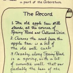
[Illustration of a farmer with a shovel standing next to a sapling] Header: AN APPLE TREE was planted on a farm, many years ago / The farm later became a part of the Arboretum
Text and illustrations from top to bottom:
- [Depicted in stylized scroll] The Record:
- 1) The old apple tree still stands, at the corner of Spring Road and Oakwood Drive.
- 2) Across the road from the apple tree is a bit of the old well curb.
- 3) Nearby, along Spring Road, is a spring, with a bit of cemented wall that was probably the base of the farmer's spring house. [illustration of a tree]
Extent: 1 sheet
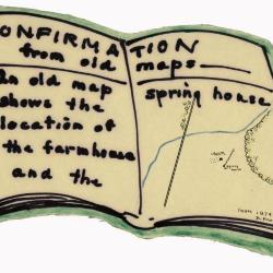
Arboretum Landscape Teaching Aid Series: Confirmation from Old Maps (3.19500)
Date: 1940 – 1960Creator: Watts, May Theilgaard
Type: Drawing
Description:Primarily textual teaching aid depicting Arboretum landscape. This material is depicted in the shape of an open book. It shows a drawing of an old map of the farm that later became the Arboretum.
Header: CONFIRMATION from old maps
Text and illustrations from top to bottom, left to right:
- text: An old map shows the location of the farmhouse and the spring house
- map illustration: a road extending from bottom to top, a stream extending from left to right, trees at top and right, and a small patch of farm land at center with a wall and two structures, one labeled "Solomon Mertz" and the other "Spring house"
- text, bottom right: FROM 1874 ATLAS OF DUPAGE COUNTY
Extent: 1 sheet
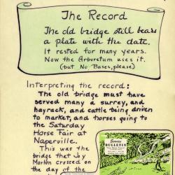
Arboretum Landscape Teaching Aid Series: An Old Bridge (3.19501)
Date: 1940 – 1960Creator: Watts, May Theilgaard
Type: Drawing
Description:Primarily textual teaching aid depicting Arboretum landscape. This material describes a bridge that was left on what are now the Arboretum grounds, as well as part of the story of the Morton Arboretum's origins.
[Illustration of the bridge] Header: AN OLD BRIDGE was left behind when the HIGHWAY cut through [illustration of the highway]
Text and illustrations from top to bottom:
- [Depicted in stylized scroll] The Record: The old bridge still bears a plate with the date. It rested for many years. Now the Arboretum uses it. (but No Buses, please)
- Interpreting the record: The old bridge must have served many a surrey, and hayrack, and cattle being driven to market, and horses going to the Saturday Horse Fair at Naperville. This was the bridge that Joy Morton crossed on the day of the event described here [to the right of this text is pasted material from the May 1952 "Service Bulletin," Vol. 21, No. 2, including the front cover illustration depicting an antique vehicle and two men putting out a brush fire and partial text describing how Joy Morton found the location where he had his home Thornhill built.]
Extent: 1 sheet

Arboretum Landscape Teaching Aid Series: Cut-Over and Grazed Land (3.19502)
Date: 1940 – 1960Creator: Watts, May Theilgaard
Type: Drawing
Description:Primarily textual teaching aid depicting Arboretum landscape. This material describes the grazed and cut-over land that was added to the Arboretum, including the effects of fencing out cattle.
[Illustration of a tree stump] Header: CUT-OVER AND GRAZED LAND was added to the Arboretum in 1910 [image of a cow's head with its tongue out]
Text and illustrations from top to bottom:
- [Depicted in stylized scroll] THE RECORD:
- 1. No big trees in this area [illustration of a tree with a large red "X" over it]
- 2. Many stump sprouts [sketch of stump sprouts]
- 3. Many aspens and big-toothed poplars [sketch of aspens and poplars]
- 4. Young oaks, many of the same age [sketch of oaks]
- INTERPRETATION of THE RECORD:
- 1. Aspens and big-toothed poplars grow in sunny places.
- 2. The even age oaks show by their annual rings that they started growing on the year that the Arboretum fenced cows from this area.
- 3. The wild flowers have returned steadily to this area. There was only thistles, milkweed, dandelions, and other tough ones, there when the cattle were fenced out. Now there are trilliums, spring beauties, blood-root, may-apple, and many, many, others.
Extent: 1 sheet
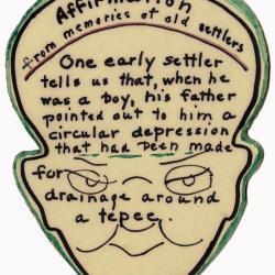
Arboretum Landscape Teaching Aid Series: Affirmation from Memories of Old Settlers, Part I (3.19503)
Date: 1940 – 1960Creator: Watts, May Theilgaard
Type: Drawing
Description:Primarily textual teaching aid depicting Arboretum landscape. This material is depicted in the shape of a head, including sketches of eyes, a nose, and mouth. It describes the childhood memories of an early settler who recalls that a teepee may have been constructed in the area at one time.
Header: Affirmation from memories of old settlers
Text from top to bottom:
- One early settler tells us that, when he was a boy, his father pointed out to him a circular depression that had been made for drainage around a tepee.
Extent: 1 sheet
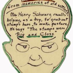
Arboretum Landscape Teaching Aid Series: Affirmation from Memories of Old Settlers, Part II (3.19504)
Date: 1940 – 1960Creator: Watts, May Theilgaard
Type: Drawing
Description:Primarily textual teaching aid depicting Arboretum landscape. This material is depicted in the shape of a head, including sketches of eyes, a nose, and mouth. It describes the childhood memories of an early settler who recalls pulling up stumps to help create pasture as a boy.
Header: Affirmation from memories of old settlers
Text from top to bottom:
- Mr Henry Schwarz recalls helping, as a boy, to grub out stumps here to make pasture. He says "The stumps were Big and Close"
Extent: 1 sheet
Arboretum Landscape Teaching Aid Series: Trees Keep Records (3.19505)
Date: 1940 – 1960Creator: Watts, May Theilgaard
Type: Drawing
Description:Primarily textual teaching aid depicting Arboretum landscape. This material describes the biography of a red oak tree with illustrations and text.
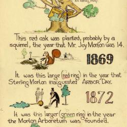
Header: TREES KEEP RECORDS [Illustration of a tree writing in a book with a quill pen, saying "it's nothing, really!"]
Text and illustrations from top to bottom, left to right:
- This red oak was planted, probably by a squirrel, the year that Mr. Joy Morton was 14. [Illustration of a squirrel planting an acorn with a shovel and a sketch of a high wheel bike and cyclist in the background, followed by the year 1869]
- It was this large (red ring) in the year that Sterling Morton inaugurated ARBOR DAY. [Illustration of men in top hats and suits planting trees, followed by the year 1872]
- It was this larger (green ring) in the year the Morton Arboretum was founded. [Illustration of a path with trees, followed by the year 1921]
- It grew vigorously in its youth and then slowed down.
Extent: 1 sheet

Arboretum Landscape Teaching Aid Series: Three Norway Spruces (3.19506)
Date: 1940 – 1960Creator: Watts, May Theilgaard
Type: Drawing
Description:Primarily textual teaching aid depicting Arboretum landscape. This material describes the three Norway spruce trees planted by Joy Morton, Wirt Morton, and Sterling Morton, including a pasted Arboretum map of their location on the grounds.
Header: THREE Norway Spruces [image of three stylized trees] were planted by THREE Mortons / JOY MORTON / WIRT MORTON / STERLING MORTON
Text and illustrations from top to bottom:
- [Depicted in stylized scroll] THE RECORD: Three Tall Trees [Illustration of three trees] On Forest Road [followed by an arrow pointing downward to map below]
- map: the 3 spruces [arrow pointing downward to spot on map where trees are located, on Forest Road]. Label in lower right: GUIDE MAP of THE MORTON ARBORETUM LISLE, ILLINOIS
- text below map: *these trees are one answer to the ever occurring question: HOW FAST DO TREES GROW?
Extent: 1 sheet
Arboretum Landscape Teaching Aid Series: Early Settlers Brought Roses (3.19507)
Date: 1940 – 1960Creator: Watts, May Theilgaard
Type: Drawing
Description:Primarily textual teaching aid depicting Arboretum landscape. This material describes locations of sites where roses were obtained for the Old-Fashioned Rose Garden.
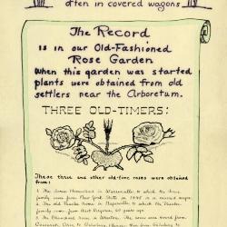
Header [framed by illustrations of rose bushes, one red and one pink]: Early Settlers Brought ROSES from the East often in covered wagons
Text and illustrations from top to bottom:
- [Depicted in stylized scroll] The Record is in our Old-Fashioned Rose Garden / When this garden was started plants were obtained from old settlers near the Arboretum.
- THREE OLD-TIMERS: [Illustration of three types of roses, from left to right]
- Harrison's Yellow
- moss rose
- Cabbage rose
- These three and other old-time roses were obtained from:
- 1. The Jones Homestead in Warrenville, to which the Jones family came from New York State in 1845 in a covered wagon.
- 2. The old Peaslee home in Naperville, to which the Peaslee family came, from West Virginia, 60 years ago.
- 3. The Blanchard home in Wheaton. The roses were moved from Cincinnati, Ohio, to Galseburg, Illinois; then from Galesburg to Wheaton.
- 4. The property given by President Jonathan Blanchard, first president of Wheaton College, in 1890, to his daughter.
- 5. The oldest house in Wheaton, (corner of Naperville Rd. and Roosevelt) built by Warren Wheaton, who came from Connecticut in 1837, and built the house in 1847.
- and others
Extent: 1 sheet
Arboretum Landscape Teaching Aid Series: Indian Trails and Villages (3.19508)
Date: 1940 – 1960Creator: Watts, May Theilgaard
Type: Drawing
Description:Primarily textual teaching aid depicting Arboretum landscape. This material describes a Native American chipping station and village located on what later became The Morton Arborteum grounds. It also includes a map showing locations of other Native American sites and trails throughout the Chicagoland area. An arrowhead wrapped in plastic is still attached on the left, while a second arrowhead appears to be missing on the right.
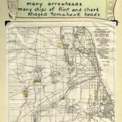
Header: INDIANS had a chipping station and a village here ----
Text and illustrations from top to bottom:
- [Depicted in stylized scroll] [Arrowhead wrapped in plastic] THE RECORD many arrowheads many chips of flint and chert shaped tomahawk heads [plastic wrapping]
- Map: INDIAN TRAILS AND VILLAGES OF CHICAGO AND OF COOK, DUPAGE AND WILL COUNTIES, ILLS. (1804) AS SHOWN BY WEAPONS AND IMPLEMENTS OF THE STONE-AGE / COPYRIGHTED 1900 & 1901 ALBERT F. SCHARF. / - INDEX - [with map symbols]
- INDIAN VILLAGES (NUMBERED) [teepee symbol]
- MINOR INDIAN VILLAGES [triangle with "x" at top]
- INDIAN CAMPS [triangle]
- CHIPPING STATIONS [inverted triangle]
- PRINCIPAL INDIAN TRAILS LETTERED AND NUMBERED [line]
- PORTAGE [concave depression]
- SPRINGS [inverted "J"]
- HEIGHTS AND SIGNAL STATIONS [cross]
- INDIAN MOUNDS [circle with dot in center]
- MOUND BUILDERS TRAIL [mound symbol]
- Text at bottom of map: AN ARCHEOLOGICAL MAP OF CHICAGO AND VICINITY / This map, the work of Albert F. Scharf, is reproduced by the courtesy of Mr. Scharf and the Chicago Historical Society.
- Text below map: Arboretum in green
Extent: 1 sheet
Arboretum Landscape Teaching Aid Series: Know, Know, Know Your Oaks, This Is How They Grow (3.19509)
Date: 1940 – 1960Creator: Watts, May Theilgaard
Type: Drawing
Description:Primarily textual teaching aid depicting Arboretum landscape. This material describes the growth direction of five types of oak tree branches. Illustrations depict small human-shaped figures that indicate tree branch growth with arms and run diagonally down the center of the image with descriptive text on either side.
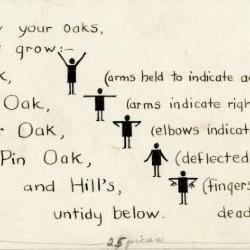
Header: Know, know, know your oaks, / This is how they grow:
Text and illustrations from top to bottom:
- Red Oak, [illustration of figure with arms raised overhead] (arms held to indicate acute-angled branching)
- White Oak, [illustration of figure with arms raised to shoulders] (arms indicate right-angled branching)
- Bur Oak, [illustration of figure with arms raised to shoulder and elbows bent down] (elbows indicated gnarled branching)
- Pin Oak, [illustration of figure with arms extended at sides] (deflected lower branches)
- and Hill's, untidy below. [illustration of figure with arms raised to shoulder, elbows bent down, and fingers splayed] (fingers indicate deflected, dead, lower branches)
Extent: 1 sheet
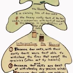
Arboretum Landscape Teaching Aid Series: Forest Met Prairie (3.19510)
Date: 1940 – 1960Creator: Watts, May Theilgaard
Type: Drawing
Description:Primarily textual teaching aid depicting Arboretum landscape. This material is depicted in the shape of a bur oak leaf. It describes how a line of bur oaks indicates where the climax forest and climax prairie met.
Header: FOREST met PRAIRIE [illustration of grass and trees]
Text and illustrations from top to bottom:
- The Record
- 1. a curving line of bur oaks
- 2. the heavy corky bark of the bur oaks, in comparison with bark of red oak.
- 3. the change in soil profiles at edge of oaks this [illustration of soil] to this [illustration of darker soil]
- Interpreting the Record
- 1) Because bur oaks, with their corky bark were best able to withstand the fires that swept the prairies (often set by Indians) and
- 2) because bur oaks are best at withstanding dry prairie winds
- 3) because bur oaks are seldom found in the heart of the woods
- We Read that: this line of bur oaks marks the place where the climax forest met the prairie climax
Extent: 1 sheet