Browsing by object type: language:
Stormwater Master Plan (3.100277)
Date: August 26 1999Creator: Christopher B. Burke Engineering, Ltd.
Type: Map
Description:Areas outlined or highlighted with color markers.
Extent: 1 sheet
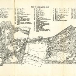
Data Concerning The Morton Arboretum and Map (3.106097)
Date: May 17 1930Type: Map
Description:Issue of the Bulletin of Popular Information with data concerning The Morton Arboretum and guide map.
Guide map details Arboretum roads, plant collections, buildings and points of interest. Collections are numbered and identified by a key at the top of the map.
The reverse side features information about the Arboretum including founding date, location, general organization of collections, the Bulletin of Popular Information, and how to reach the Arboretum.
Extent: 1 sheet
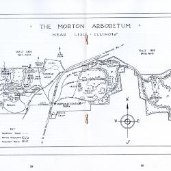
The Morton Arboretum Near Lisle, Illinois (3.106098)
Date: September 27 1934Creator: Kammerer, E. Lowell
Type: Map
Description:Guide map to The Morton Arboretum that is included in an issue of the Bulletin of Popular Information (Vol. 9, No. 9). Guide map details Arboretum roads, plant collections, buildings and points of interest. Key indicates proposed roads, native woodland, and forestry plots.
The remaining pages of the booklet include a biography of Joy Morton, a description of the Arboretum, a map showing how to reach the Arboretum, and a list of the Board of Trustees and lead staff members.
Extent: 14 pages
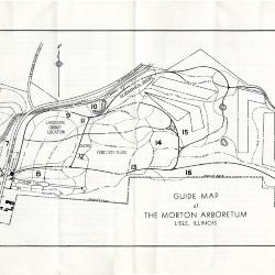
Guide Map of The Morton Arboretum (3.106099)
Date: 1936Type: Map
Description:Double-sided brochure with general information and a guide map of The Morton Arboretum.
Guide map details Arboretum roads, trails, parking, plant collections, buildings and points of interest. Sixteen areas on the grounds highlighted in the key and identified with numbers on the map.
Reverse side provides facts about the Arboretum, rules and regulations, and a list of the Board of Trustees and lead staff members.
Extent: 1 sheet
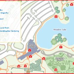
The Morton Arboretum Visitors Map and Guide (3.106100)
Date: 1994Creator: Halenza, D.
Type: Map
Description:Double-sided brochure, Visitors Map and Guide for The Morton Arboretum.
Map details Arboretum roads, trails, plant collections, buildings and boundaries.
Reverse side provides general information about the Arboretum, classes, Plant Clinic, the Sterling Morton Library, and the Visitor Center, which includes the Ginkgo Restaurant and Coffee Shop and Ginkgo Shop. Also includes a map showing how to reach the Arboretum.
Extent: 1 sheet
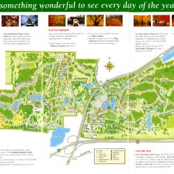
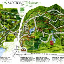
The Morton Arboretum Visitor Map Fall 2005 (3.106101)
Date: 2005Creator: Pulse Design, Inc.
Type: Map
Description:Double-sided brochure, Visitor Map and guide for The Morton Arboretum.
Map details Arboretum roads, trails, plant collections, buildings and boundaries. Includes more detailed maps of the areas around the Thornhill Education Center ad the Visitor Center. Text surrounding the maps lists West and East Side highlights and trails.
Reverse side provides general information about the Arboretum, seasonal highlights, programs, and events.
Extent: 1 sheet

Vegetation of the Chicago Region as Mapped by the Public Land Survey 1821-1845 (3.113833)
Date: 2014Creator: Halsey, Sam, McBride, Jenny
Type: Map
Description:A map created in 2006 portraying vegetation of the Chicago Region from 1821-1845.

Vegetation of the Northwest Indiana as Mapped by the Public Land Survey 1829-1835 (3.113834)
Date: 2015Creator: McBride, Jenny, Halsey, Sam
Type: Map
Description:A map created in 2006 portraying vegetation of Northwest Indiana from 1829-1835.

Vegetation of the Southwest Michigan as Mapped by the Public Land Survey 1828-1842 (3.113835)
Date: 2015Type: Map
Description:A map created in 2006 portraying vegetation of Southwest Michigan from 1828-1942.

Vegetation of the Southeast Wisconsin as mapped by the Public Land Survey 1833-1836 (3.113836)
Date: 2015Creator: Halsey, Sam
Type: Map
Description:A map created in 2006 portraying vegetation of Southeast Wisconsin from 1833-1836.

Vegetation of the Prairie Peninsula Region of Southern Lake Michigan as Mapped by the Public Land Survey 1829-1835 (3.113837)
Date: 2015Creator: Halsey, Sam, McBride, Jenny
Type: Map
Description:A map created in 2006 portraying vegetation of Prairie Peninsula Region of Southern Lake Michigan from 1829-1835.
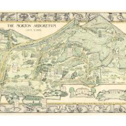
Morton Arboretum Map (3.19479)
Date: 1943Creator: Watts, May Theilgaard
Type: Map
Description:2014 reprint of The Morton Arboretum's first color map, circa 1943.
Detailed map of Arboretum grounds, showing roads, paths, landscaping, shelters, structures, enlargement of some specific features, hedge garden, some specific trees, and trails with markers numbered 1 - 42. Other features include a scale, a calendar, and a compass rose consisting of directions depicted with leaves. A highly ornamental border includes grid marks, as well as drawings of animal tracks and detailed drawings and labels of plants. The Morton Arboretum encompassed 813 acres at time of map.
Extent: 1 sheet

Morton Arboretum Map (3.19481)
Date: 1943Creator: Watts, May Theilgaard
Type: Map
Description:Detailed map of Arboretum grounds, showing roads, paths, landscaping, shelters, structures, enlargement of some specific features, hedge garden, some specific trees, and trails with markers numbered 1 - 42. Other features include a scale, a calendar, and a compass rose consisting of directions depicted with leaves. A highly ornamental border includes grid marks, as well as drawings of animal tracks and detailed drawings and labels of plants. Some replacement illustration and text has been adhered to the map. The Morton Arboretum encompassed 813 acres at time of map. One section is partially missing.
Extent: 1 sheet
Nature Connects Map (3.31593)
Date: 2015Type: Map
Description:A visitor map of the locations of all 13 LEGO sculptures of the Nature Connects: Art with LEGO Bricks by Sean Kenney exhibit.
[Aerial Photographs of] The Morton Arboretum (3.33720)
Date: March 25 1986Creator: Sidwell Company
Type: Map
Extent: 5 sheets
[Aerial Photographs of] The Morton Arboretum (3.33721)
Date: March 25 1986Creator: Sidwell Company
Type: Map
Extent: 5 sheets
[Aerial Photographs of] The Morton Arboretum (3.33778)
Date: April 1986Creator: Sidwell Company
Type: Map
Extent: 6 Sheets
[Aerial Photographs of The Morton Arboretum] (3.33779)
Date: November 29 1990Creator: Sidwell Company
Type: Map
Description:Aerial photograph taken Nov. 29, 1990 to be used in conjunction with the Sidwell Company's revised topographic map issued in 1990 ( SURV: A III (c) 2 1990 ). Collections grid crosses set out on Arboretum grounds are represented in the aerial survey by open triangles.
Extent: 5 sheets
[Aerial Photographs of] The Morton Arboretum (3.33780)
Date: April 1986Creator: Sidwell Company
Type: Map
Extent: 6 sheets
Plat of Survey of Part of the Southeast 1/4 of Section 34 & the Southwest 1/4 of Section 35, Township 39 North, Range 10, East of the Third Principal Meridian, in DuPage County, Illinois. (3.33785)
Date: October 8 1992Creator: Roake & Associates, Inc.
Type: Map
Extent: 1 sheet
Plat of Survey Showing the Location of Certain Buildings Under Construction on The Morton Arboretum Property in Lisle, Illinois (3.33786)
Date: December 7 1989Creator: Steinbrecher Jr., Harold F.
Type: Map
Extent: 1 sheet

General Information and Guide Map of The Morton Arboretum (3.34267)
Date: 1941Type: Map
Description:Doublesided brochure with general information and a guide map of The Morton Arboretum.
Guide map details Arboretum roads, trails, parking, plant collections, buildings and points of interest. Fifteen areas on the grounds highlighted in the key and identified with circled numbers on the map. Surfaced roads, gravel roads, and paths distinguished on the map by the type of line drawn. Compass showing directions north, south, east, west as well as scale indicator above top center of map.
Reverse side provides general information about the Arboretum, rules and regulations, and information about the Arboretum publication, Bulletin of Popular Information.
Extent: 1 sheet

General Information and Guide Map of The Morton Arboretum (3.34268)
Date: 1942Type: Map
Description:Doublesided brochure with general information and a guide map of The Morton Arboretum.
Guide map details Arboretum roads, trails, parking, plant collections, buildings and points of interest. Vegetation illustrated throughout map. Three stylized trees under compass showing directions north, south, east, west as well as scale indicator above top center of map.
Reverse side provides general information about the Arboretum, rules and regulations, outstanding features, buildings, Arboretum publications, and location.
Extent: 1 sheet

A Guide Map of The Morton Arboretum (3.34269)
Date: 1969Creator: Tyznik, Anthony
Type: Map
Description:A guide map of The Morton Arboretum created by Tony Tyznik in 1969. The background is a dark green with the inner Arboretum being a light green and Arboretum roads highlighted in solid orange and checkered orange lines.
Extent: 1 sheet

Map & Visitor Guide, The Morton Arboretum (3.34271)
Date: 1982 – 1986Type: Map
Description:Double-sided brochure, Map & Visitor Guide for The Morton Arboretum
Map details Arboretum roads, trails, plant collections, buildings and boundaries. Includes photographs of various Arboretum buildings with descriptive information.
Reverse side provides general information about the Arboretum, trails for walking and hiking, driving through the Arboretum, areas and collections of special interest, native plant communities, wildlife at the Arboretum, regulations, facilities and services, and information on membership. A section of the map is enlarged to identify landmarks around the Visitor Center, Administration Building, and Thornhill Education Center.
Extent: 1 sheet
The Morton Arboretum (3.35347)
Date: 1986Creator: Sidwell Company
Type: Map
Description:The maps shows images taken on December 16, 1985. The copyright date of the maps is 1986.
Extent: 5 sheets
The Morton Arboretum (3.35349)
Date: 1990Creator: Sidwell Company
Type: Map
Description:The maps show images taken on December 16, 1985 and also April 25, 1990. The copyright date of the maps is 1990.
These maps are part of a 5 sheet set, but sheet 5 is missing.
Extent: 4 sheets
South Farm Land Use (3.35375)
Date: December 30 1988Creator: Kelsey, Pat
Type: Map
Description:Feb. 13, 1989: Survey data added.
Revision
Extent: 1 sheet
Plat of Survey Morton Arboretum Agreement Line (3.35378)
Date: February 11 1992Creator: Roake & Associates, Inc.
Type: Map
Extent: 1 sheet
Tract Map of The Morton Arboretum 1982 Sheet 2 (3.36143)
Date: March 8 1972Creator: Steinbrecher, Harold F.
Type: Map
Description:Dated March 8, 1972. Revised on November 29, 1979. Surroundings updated on May 25, 1982.
Hidden Lake Wetland Site Work Plan (3.36157)
Date: February 18 1987Type: Map
Description:Illinois State Highway Authority
Section A-A
Hand colored
Preliminary
Extent: 1 page
Woody Plant Collections: Historic Views (3.41528)
Date: April 1999Creator: Walker, Catherine
Type: Map
Description:Tracing over Arboretum brochure (Woody Plant Collections of The Morton Arboretum) with notations from Catherine Walker. Numbers relate to photograph booklet.
Extent: 1 sheet
Compensatory Storage Facility As-Built (3.44574)
Date: February 24 2004Creator: Christopher B. Burke, Engineering West, Ltd.
Type: Map
Description:Topographic map prepared for purpose of depicting existing grading on 9-17-2003.
Project number 00-927AA
Extent: 1 Sheet
Meadow Lake Improvements Vicinity Topographic Map (3.44576)
Date: December 2 2002Creator: Montgomery Watson Harza (MWH)
Type: Map
Description:
Extent: 1 sheet