
Evergreen Nature Trail Guide (3.24009)
Date: 1940sCreator: Watts, May Theilgaard
Type: Book
Description:The Morton Arboretum Evergreen Nature Trail Guide booklet: commercial reproduction of the original art with additional descriptive text.
The booklet contains 16 pages of information about the Evergreen Nature Trail and includes maps on front cover and second page, key to the trees in the woods on back cover, and other pages with illustrations and text descriptions of trail features.
Two versions of the commercially printed booklet have been identified with a difference in the front cover (page 1) as to where the trail begins: Parking Number Two and Parking Number Thirteen.
Extent: 1 booklet (3 copies)
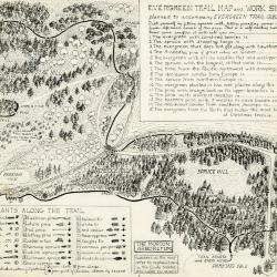
Evergreen Nature Trail Guide: evergreen trail map and work sheet (3.24663)
Date: 1940sCreator: Watts, May Theilgaard
Type: Document
Description:Original illustrations and layout for the Evergreen Trail Map and Work Sheet planned to accompany The Morton Arboretum Evergreen Trail Guide booklet. Signed "by M. T. Watts" in bottom right corner.
Work sheet in top right corner included to test your conifer knowledge. Bottom left list of plants along the trail used in conjunction with worksheet in top right corner.
Illustrated map includes names of plants along the trail as well as numbers referring to explanations in the Guide booklet.
Extent: 1 sheet

Evergreen Nature Trail Guide, page 2 illustrations and layout with preliminary sketches (3.24676)
Date: 1940sCreator: Watts, May Theilgaard
Type: Drawing
Description:Sheet One: Original illustrations and layout for page 2 (inside front cover), excluding text, for The Morton Arboretum Evergreen Nature Trail Guide booklet. Key lines included.
Introductory page to trail guide, including map of the trail's location on Arboretum grounds near parking lot 2. Map header text "LOCATION OF EVERGREEN NATURE TRAIL in the Arboretum" points arrow to Evergreen Nature Trail on map. Thornhill Building and Administration Building identified in map for reference to trail location on grounds.
Map also identifies 2 other trails in the Arboretum:
Thornhill Trail - identified by circles located near Thornhill Building
Forest Trail - identified by crosses in far right section of the map
Sheet Two: Preliminary sketch of green-colored map with page number and various ink lines.
Extent: 2 sheets

General Information and Guide Map of The Morton Arboretum (3.34267)
Date: 1941Type: Map
Description:Doublesided brochure with general information and a guide map of The Morton Arboretum.
Guide map details Arboretum roads, trails, parking, plant collections, buildings and points of interest. Fifteen areas on the grounds highlighted in the key and identified with circled numbers on the map. Surfaced roads, gravel roads, and paths distinguished on the map by the type of line drawn. Compass showing directions north, south, east, west as well as scale indicator above top center of map.
Reverse side provides general information about the Arboretum, rules and regulations, and information about the Arboretum publication, Bulletin of Popular Information.
Extent: 1 sheet

General Information and Guide Map of The Morton Arboretum (3.34268)
Date: 1942Type: Map
Description:Doublesided brochure with general information and a guide map of The Morton Arboretum.
Guide map details Arboretum roads, trails, parking, plant collections, buildings and points of interest. Vegetation illustrated throughout map. Three stylized trees under compass showing directions north, south, east, west as well as scale indicator above top center of map.
Reverse side provides general information about the Arboretum, rules and regulations, outstanding features, buildings, Arboretum publications, and location.
Extent: 1 sheet

A Guide Map of The Morton Arboretum (3.34269)
Date: 1969Creator: Tyznik, Anthony
Type: Map
Description:A guide map of The Morton Arboretum created by Tony Tyznik in 1969. The background is a dark green with the inner Arboretum being a light green and Arboretum roads highlighted in solid orange and checkered orange lines.
Extent: 1 sheet

Map & Visitor Guide, The Morton Arboretum (3.34271)
Date: 1982 – 1986Type: Map
Description:Double-sided brochure, Map & Visitor Guide for The Morton Arboretum
Map details Arboretum roads, trails, plant collections, buildings and boundaries. Includes photographs of various Arboretum buildings with descriptive information.
Reverse side provides general information about the Arboretum, trails for walking and hiking, driving through the Arboretum, areas and collections of special interest, native plant communities, wildlife at the Arboretum, regulations, facilities and services, and information on membership. A section of the map is enlarged to identify landmarks around the Visitor Center, Administration Building, and Thornhill Education Center.
Extent: 1 sheet