Browsing by Subject/Keyword: object type:
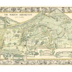
Morton Arboretum Map (3.19479)
Date: 1943Creator: Watts, May Theilgaard
Type: Map
Description:2014 reprint of The Morton Arboretum's first color map, circa 1943.
Detailed map of Arboretum grounds, showing roads, paths, landscaping, shelters, structures, enlargement of some specific features, hedge garden, some specific trees, and trails with markers numbered 1 - 42. Other features include a scale, a calendar, and a compass rose consisting of directions depicted with leaves. A highly ornamental border includes grid marks, as well as drawings of animal tracks and detailed drawings and labels of plants. The Morton Arboretum encompassed 813 acres at time of map.
Extent: 1 sheet

Morton Arboretum Map (3.19481)
Date: 1943Creator: Watts, May Theilgaard
Type: Map
Description:Detailed map of Arboretum grounds, showing roads, paths, landscaping, shelters, structures, enlargement of some specific features, hedge garden, some specific trees, and trails with markers numbered 1 - 42. Other features include a scale, a calendar, and a compass rose consisting of directions depicted with leaves. A highly ornamental border includes grid marks, as well as drawings of animal tracks and detailed drawings and labels of plants. Some replacement illustration and text has been adhered to the map. The Morton Arboretum encompassed 813 acres at time of map. One section is partially missing.
Extent: 1 sheet

General Information and Guide Map of The Morton Arboretum (3.34267)
Date: 1941Type: Map
Description:Doublesided brochure with general information and a guide map of The Morton Arboretum.
Guide map details Arboretum roads, trails, parking, plant collections, buildings and points of interest. Fifteen areas on the grounds highlighted in the key and identified with circled numbers on the map. Surfaced roads, gravel roads, and paths distinguished on the map by the type of line drawn. Compass showing directions north, south, east, west as well as scale indicator above top center of map.
Reverse side provides general information about the Arboretum, rules and regulations, and information about the Arboretum publication, Bulletin of Popular Information.
Extent: 1 sheet

General Information and Guide Map of The Morton Arboretum (3.34268)
Date: 1942Type: Map
Description:Doublesided brochure with general information and a guide map of The Morton Arboretum.
Guide map details Arboretum roads, trails, parking, plant collections, buildings and points of interest. Vegetation illustrated throughout map. Three stylized trees under compass showing directions north, south, east, west as well as scale indicator above top center of map.
Reverse side provides general information about the Arboretum, rules and regulations, outstanding features, buildings, Arboretum publications, and location.
Extent: 1 sheet

A Guide Map of The Morton Arboretum (3.34269)
Date: 1969Creator: Tyznik, Anthony
Type: Map
Description:A guide map of The Morton Arboretum created by Tony Tyznik in 1969. The background is a dark green with the inner Arboretum being a light green and Arboretum roads highlighted in solid orange and checkered orange lines.
Extent: 1 sheet

Map & Visitor Guide, The Morton Arboretum (3.34271)
Date: 1982 – 1986Type: Map
Description:Double-sided brochure, Map & Visitor Guide for The Morton Arboretum
Map details Arboretum roads, trails, plant collections, buildings and boundaries. Includes photographs of various Arboretum buildings with descriptive information.
Reverse side provides general information about the Arboretum, trails for walking and hiking, driving through the Arboretum, areas and collections of special interest, native plant communities, wildlife at the Arboretum, regulations, facilities and services, and information on membership. A section of the map is enlarged to identify landmarks around the Visitor Center, Administration Building, and Thornhill Education Center.
Extent: 1 sheet
Visitor Center Parking Lot [topographic] Survey (3.5271)
Date: March 20 1989Creator: Hootman, Rick
Type: Map
Extent: 1 sheet
A parking development for Thornhill Building (3.5597)
Creator: Tyznik, Anthony
Type: Map
Extent: 1 sheet
[Arbordale Development Plan and Traffic-flow Design] (3.5746)
Date: circa 1956Creator: Howard T. Fisher & John D. Randall Associates, Inc., Tyznik, Anthony
Type: Map
Description:Basic map was done by Howard T. Fisher & John D. Randall Associates of Chicago. The map contains a ms. note of C. E. Godshalk.
Extent: 1 sheet
[Plan of Development for Morton Arboretum, Lisle, Illinois, with preliminary collections grid and Arboretum's location with reference to northeastern Illinois] (3.5776)
Date: circa 1935Type: Map
Description:One of 3 closely related maps, untitled and undated, developed during the mid-1930s.
This map may have been prepared for collateral use in the Arboretum's informal series titled: Map & Visitor Guide. It contains schematic depiction of major plant collections, roads, and trails. This map also uniquely shows the collections grid in a preliminary format. A small diagram is also included in the upper right corner showing the Arboretum's location with reference to northeastern Illinois.
"Cross section map whole Arboretum" written in pencil on back of map.
Extent: 1 sheet
[Plan of Development for Morton Arboretum, Lisle, Illinois, some landmarks numbered 1-15] (3.5778)
Date: circa 1935Type: Map
Description:One of three closely related maps, untitled and undated, developed during the mid-1930s.
This map shows major plant collections, boundaries, roads, and trails in line drawing. Some landmarks on map are numbered 1-15, but no key is drawn alongside the map to identify the numbered areas.
"Plan of Arboretum" written in ink on back of map.
Extent: 1 sheet
A Guide Map of The Morton Arboretum, Lisle, Illinois [1958? with roads and parking colored] (3.5780)
Date: circa 1958Creator: Tyznik, Anthony
Type: Map
Description:The map was probably designed for collateral use in the Arboretum's informal series titled: Map & visitor guide. Roads showing direction of traffic and parking areas have been colored in with colored pencil.
Extent: 1 sheet
A Guide Map of The Morton Arboretum, Lisle, Illinois [1958? with updates] (3.5781)
Date: circa 1958Creator: Tyznik, Anthony
Type: Map
Description:Probably prepared for collateral use in the Arboretum's informal series titled: Map & Visitor Guide. The map has been updated by mounting a small mylar sheet on the left margin. The addition shows the Sterling Pond and nearby areas. Roads, lakes, and parking have been colored in colored pencil.
Extent: 1 sheet
Woody Plant Collections, The Morton Arboretum [by Ronald M. Coulter and Nancy Hart Stieber] (3.5809)
Date: 1982Creator: Coulter, Ronald M.
Type: Map
Description:The map (in color) appears on the verso of the informational flier titled: Woody Plant Collections of The Morton Arboretum: Map & Guidelines for Locating Plants. On recto of flier a narrative description of the collections is given, together with directions on how to locate plants using the collections grid, and index to the collections. Various sizes and formats of the map only are available in the collection: reproductions on paper and in transparency and photographic negatives (various sizes, scales, and formats).
Extent: 1 sheet
Map and Visitor Guide [of] The Morton Arboretum [by Nancy Hart Stieber and John Sosnowski, various sections broken down into multiple negatives] (3.5819)
Date: 1984Creator: Hart, Nancy
Type: Map
Description:Seven photographic negatives depicting various sections of the map portion for the production of the Map & Visitor Guide. Updated in 1989 with Crabapple Lake.
Extent: Envelope with 7 film negatives
Map and Visitor Guide [of] The Morton Arboretum [by Nancy Hart Stieber and John Sosnowski enlarged sections of landmarks and vegetation] (3.5821)
Date: 1984Creator: Hart, Nancy
Type: Map
Description:Enlarged sections of landmarks and vegetation of the map portion of the Map & Visitor Guide created for production. Updated in 1989 with Crabapple Lake.
Extent: Folio of 12 items
Woody Plant Collections, The Morton Arboretum [Collections Grid, by Ronald M. Coulter and Nancy Hart Stieber, 1990, base map of roads and parking lots] (3.5825)
Date: 1990Creator: Coulter, Ronald M.
Type: Map
Description:An updated map used in the informational leaflet titled: Woody Plant Collections of The Morton Arboretum, Map & Guidelines for Locating Plants
This version only shows base map of roads and parking lots.
Extent: 1 sheet
A Guide Map of The Morton Arboretum, Lisle, Illinois [1958? with written notes on road development] (3.5995)
Date: circa 1958Creator: Tyznik, Anthony
Type: Map
Description:Probably prepared for collateral use in the Arboretum's informal series titled: Map & Visitor Guide.
Includes misc notes by C.E. Godshalk on road building and lakes.
Extent: 1 sheet
A Guide Map of The Morton Arboretum, Lisle, Illinois [1958? with written notes on major planting dates since 1922] (3.5996)
Date: circa 1958Creator: Tyznik, Anthony
Type: Map
Description:Probably prepared for collateral use in the Arboretum's informal series titled: Map & Visitor Guide.
Includes misc notes by C.E. Godshalk on major planting dates since 1922 for various collections and landmarks.
Extent: 1 sheet
A Guide Map of The Morton Arboretum, Lisle, Illinois [1958? with written notes regarding land purchases and use] (3.5997)
Date: circa 1958Creator: Tyznik, Anthony
Type: Map
Description:Probably prepared for collateral use in the Arboretum's informal series titled: Map & Visitor Guide.
Includes misc notes by C.E. Godshalk regarding land purchases and use.
Extent: 1 sheet
A Proposed Utility and Parking Plan for The Morton Arboretum (3.6135)
Date: July 30 1981Creator: Tyznik, Anthony
Type: Map
Description:Developed for the Research Center construction.
Extent: 1 sheet
Gas Light Layout from Parking 1 to Administration and Research Center (3.6211)
Date: September 25 1995Creator: Mehaffey, Scott A.
Type: Map
Description:33 path lights for 1995; 16 parking lot lights for 1996
Extent: 1 sheet
Woody Plant Collections, The Morton Arboretum [Collections Grid, by Ronald M. Coulter and Nancy Hart Stieber, 1990, colored with mowing schedule] (3.6293)
Date: 1990Creator: Coulter, Ronald M.
Type: Map
Description:An updated map used in the informational leaflet titled: Woody Plant Collections of The Morton Arboretum, Map & Guidelines for Locating Plants
This version is hand colored and labeled to show mowing schedule.
Extent: 1 sheet
[Morton Arboretum Map and Guide, 1994, original artwork] (3.6304)
Date: 1994Creator: Halenza, D.
Type: Map
Description:Original artwork for map. Both sheets cut in half at Route 53, taped to board. Colored map shows structures, roads, parking lots, collections. Includes mylar sheet overlay showing trails. Revised 7/99 and 8/00.
Extent: 2 sheets mounted to board
A General Plan of a Section of The Morton Arboretum, Showing Water Lines, Wells, Roads, Buildings, Elevations (3.6412)
Date: circa 1955Creator: Tyznik, Anthony
Type: Map
Extent: 2 sheets
Morton Arboretum site lighting, Lisle, Illinois, lower campus lighting plan (3.6426)
Creator: A. Epstein & Sons
Type: Map
Description:Sheet 2: Lighting fixture schedule
Extent: 2 sheets
Morton Arboretum site lighting, Lisle, Illinois, lower campus lighting plan (3.6427)
Creator: A. Epstein & Sons
Type: Map
Description:Sheet 2: Lighting fixture schedule
Extent: 2 sheets
A Parking and Drainage Plan for the South Farm Area, The Morton Arboretum (3.6492)
Creator: Tyznik, Anthony
Type: Map
Extent: 1 sheet
A Parking and Drainage Plan for the South Farm Area, The Morton Arboretum (3.6495)
Creator: Tyznik, Anthony
Type: Map
Description:Includes totals for stone and asphalt.
Preliminary plan without curb sections.
Extent: 1 sheet
A Parking Plan for Parking Lot No. 25, the Morton Arboretum, Lisle, Illinois (3.6516)
Creator: Tyznik, Anthony
Type: Map
Description:Includes plantings for areas around parking lot
Extent: 1 sheet
Map and Visitor Guide [of] The Morton Arboretum [by Nancy Hart Stieber and John Sosnowski, landmarks and vegetation portion] (3.6533)
Date: 1984Creator: Hart, Nancy
Type: Map
Description:Transparencies used in production of the flier showing landmarks/collections and vegetation to be used in the map portion of the informal series titled: Map & Visitor Guide. Updated in 1989 with Crabapple Lake.
Extent: Envelope with 2 items
Thornhill Building Site Plan (3.6586)
Date: March 1992Creator: Tyznik, Anthony
Type: Map
Extent: 1 sheet
Thornhill Building Site Plan (3.6587)
Date: March 1992Creator: Tyznik, Anthony
Type: Map
Description:Variant of copy 1 (3.6586)
Extent: 1 sheet
Thornhill Building Site Plan (3.6590)
Date: March 1992Creator: Tyznik, Anthony
Type: Map
Description:Variant of copy 1 (3.6586)
Collection includes two of the same map that are colored with watercolor:
#1372 (c.3) and #1373 (c.4)
Extent: 1 sheet
Thornhill Building Site Plan (3.6591)
Date: March 1992Creator: Tyznik, Anthony
Type: Map
Description:Variant of copy 1 (3.6586)
Extent: 1 sheet