
General Information and Guide Map of The Morton Arboretum (3.34268)
Date: 1942Type: Map
Description:Doublesided brochure with general information and a guide map of The Morton Arboretum.
Guide map details Arboretum roads, trails, parking, plant collections, buildings and points of interest. Vegetation illustrated throughout map. Three stylized trees under compass showing directions north, south, east, west as well as scale indicator above top center of map.
Reverse side provides general information about the Arboretum, rules and regulations, outstanding features, buildings, Arboretum publications, and location.
Extent: 1 sheet

A Guide Map of The Morton Arboretum (3.34269)
Date: 1969Creator: Tyznik, Anthony
Type: Map
Description:A guide map of The Morton Arboretum created by Tony Tyznik in 1969. The background is a dark green with the inner Arboretum being a light green and Arboretum roads highlighted in solid orange and checkered orange lines.
Extent: 1 sheet

Map & Visitor Guide, The Morton Arboretum (3.34271)
Date: 1982 – 1986Type: Map
Description:Double-sided brochure, Map & Visitor Guide for The Morton Arboretum
Map details Arboretum roads, trails, plant collections, buildings and boundaries. Includes photographs of various Arboretum buildings with descriptive information.
Reverse side provides general information about the Arboretum, trails for walking and hiking, driving through the Arboretum, areas and collections of special interest, native plant communities, wildlife at the Arboretum, regulations, facilities and services, and information on membership. A section of the map is enlarged to identify landmarks around the Visitor Center, Administration Building, and Thornhill Education Center.
Extent: 1 sheet
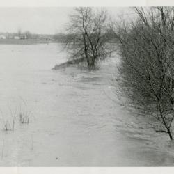
Route 53 in flood, north of Park Blvd (3.37483)
Date: 1959 – 1960Type: Photographic image
Description:Route 53 in flood, north of Park Blvd
Extent: 1 photograph
Concept Park Boulevard Entrance (3.47501)
Date: January 9 2001Creator: Christopher B. Burke, Engineering West, Ltd.
Type: Map
Description:Color aerial map showing existing entrance and exit to be removed and proposed entrance, exit, and parking facility in 2001.
"Project No. 00-910"
Extent: 1 Sheet
Topographical Map of a Portion of Assessment Plat No. 4, Lands Belonging to Trustees Under the Will of Joy Morton, Deceased, near Lisle, DuPage County, Illinois (3.5255)
Date: January 15 1954Creator: Steinbrecher, Harold F.
Type: Map
Description:Shows designs for a subdivision that was never developed in the Park Blvd. and Main Thornhill Drive area. Elevations are based on an arbitrary benchmark. "Topo of Land South of S(t)romquist, N. of Main Drive, W. Side" in pencil on reverse of map.
Extent: 1 sheet
1991/05/28: George Ware to Dr. Donnelly (3.56105)
Date: May 28 1991Creator: Ware, George
Type: Document
Description:Memo from George Ware to Dr. Donnelly discussing suggested routes for a bike path through The Morton Arboretum.
Extent: 1 sheet
Morton Arboretum map [proposed land use 1969] (3.5764)
Date: December 1969Creator: Hart, Nancy
Type: Plan
Description:Shows Arboretum structures and major connecting roads/trails from the Thornhill area to Meadow Lake and South Farm. An updated version of this map was done at a later date by Anthony Tyznik. Cover sheet states: 1969 Proposed Land Use Morton Arboretum.
Extent: 1 sheet attached to posterboard
Illinois Route 53 and Park Boulevard intersection improvement; F. A .U. Route 2578 (Ill. Rte. 53) Section 534X-N (85), DuPage County; plans for proposed state bond issue highway. (3.5889)
Date: circa 1986Creator: Illinois Division of Highways
Type: Map
Description:Imperfect copy: sheets 3-4 missing.
Extent: 24 sheets
Plat of survey of part of the southeast quarter of Section 34, Township 39 North, Range 10 east of the Third Principal Meridian, in DuPage County, Illinois, and part of the southwest quarter of Section 35, T.39N., R.10E. Of the 3rd P.M. (3.5988)
Date: August 24 1927Creator: Webster, Arthur L.
Type: Map
Description:Shows an 8.64 acre tract on the west side of the Arboretum bordering on Joliet Road, now Park Blvd.
Extent: 1 sheet
Electric Gate for Park Blvd. Exit, Thornhill Drive and Park Blvd. (3.6198)
Date: circa 1996Creator: Mehaffey, Scott A.
Type: Plan
Description:Gate elevation, gate operating systems layout, and site plan
Extent: 1 sheet
[Picnic Shelter] Plan, End and Front Elevations (3.6336)
Date: 1954Creator: Tyznik, Anthony
Type: Plan
Description:Located north of Park Blvd. and west of Rte. 53.
Front and end elevations.
Extent: 1 sheet
[Proposed Foot/Bike Bridge and Ramp Across Route 53 North of Park Blvd.] (3.6490)
Creator: Tyznik, Anthony
Type: Plan
Description:Proposed idea for bike trail across Route 53 and Park Blvd. (highlighted in color pencil).
Extent: 1 sheet
[Proposed foot/bike bridge and ramp across Route 53 north of Park Blvd.] (3.6491)
Creator: Tyznik, Anthony
Type: Plan
Description:Proposed idea for bike trail across Route 53 and Park Blvd.
Extent: 1 sheet
Conceptual Trail Design; Danada to Hidden Lake Regional Trail (3.7054)
Date: September 10 1996Creator: Forest Preserve District of DuPage County
Type: Map
Description:"Trail connection between Park Blvd. & Rt. 53"
Extent: 1 sheet
Coord. Sketch for Park Blvd. Entrance & Parking (3.7097)
Date: June 26 2001Creator: Mehaffey, Scott A.
Type: Plan
Description:Circulation study for new entry road and relocated Forest Road through near East Side. Early concept for entry road and underpass realignment, with studies for Meadow Lake and Arbor Court S.M.
Extent: 1 sheet