Browsing by Subject/Keyword: object type:
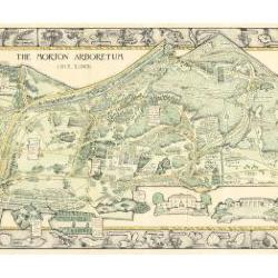
Morton Arboretum Map (3.19479)
Date: 1943Creator: Watts, May Theilgaard
Type: Map
Description:2014 reprint of The Morton Arboretum's first color map, circa 1943.
Detailed map of Arboretum grounds, showing roads, paths, landscaping, shelters, structures, enlargement of some specific features, hedge garden, some specific trees, and trails with markers numbered 1 - 42. Other features include a scale, a calendar, and a compass rose consisting of directions depicted with leaves. A highly ornamental border includes grid marks, as well as drawings of animal tracks and detailed drawings and labels of plants. The Morton Arboretum encompassed 813 acres at time of map.
Extent: 1 sheet

Morton Arboretum Map (3.19481)
Date: 1943Creator: Watts, May Theilgaard
Type: Map
Description:Detailed map of Arboretum grounds, showing roads, paths, landscaping, shelters, structures, enlargement of some specific features, hedge garden, some specific trees, and trails with markers numbered 1 - 42. Other features include a scale, a calendar, and a compass rose consisting of directions depicted with leaves. A highly ornamental border includes grid marks, as well as drawings of animal tracks and detailed drawings and labels of plants. Some replacement illustration and text has been adhered to the map. The Morton Arboretum encompassed 813 acres at time of map. One section is partially missing.
Extent: 1 sheet

General Information and Guide Map of The Morton Arboretum (3.34267)
Date: 1941Type: Map
Description:Doublesided brochure with general information and a guide map of The Morton Arboretum.
Guide map details Arboretum roads, trails, parking, plant collections, buildings and points of interest. Fifteen areas on the grounds highlighted in the key and identified with circled numbers on the map. Surfaced roads, gravel roads, and paths distinguished on the map by the type of line drawn. Compass showing directions north, south, east, west as well as scale indicator above top center of map.
Reverse side provides general information about the Arboretum, rules and regulations, and information about the Arboretum publication, Bulletin of Popular Information.
Extent: 1 sheet

General Information and Guide Map of The Morton Arboretum (3.34268)
Date: 1942Type: Map
Description:Doublesided brochure with general information and a guide map of The Morton Arboretum.
Guide map details Arboretum roads, trails, parking, plant collections, buildings and points of interest. Vegetation illustrated throughout map. Three stylized trees under compass showing directions north, south, east, west as well as scale indicator above top center of map.
Reverse side provides general information about the Arboretum, rules and regulations, outstanding features, buildings, Arboretum publications, and location.
Extent: 1 sheet

A Guide Map of The Morton Arboretum (3.34269)
Date: 1969Creator: Tyznik, Anthony
Type: Map
Description:A guide map of The Morton Arboretum created by Tony Tyznik in 1969. The background is a dark green with the inner Arboretum being a light green and Arboretum roads highlighted in solid orange and checkered orange lines.
Extent: 1 sheet

Map & Visitor Guide, The Morton Arboretum (3.34271)
Date: 1982 – 1986Type: Map
Description:Double-sided brochure, Map & Visitor Guide for The Morton Arboretum
Map details Arboretum roads, trails, plant collections, buildings and boundaries. Includes photographs of various Arboretum buildings with descriptive information.
Reverse side provides general information about the Arboretum, trails for walking and hiking, driving through the Arboretum, areas and collections of special interest, native plant communities, wildlife at the Arboretum, regulations, facilities and services, and information on membership. A section of the map is enlarged to identify landmarks around the Visitor Center, Administration Building, and Thornhill Education Center.
Extent: 1 sheet
Topographical Map of a Portion of Assessment Plat No. 1, Lands Belonging to Trustees Under the Will of Joy Morton, Deceased, near Lisle, DuPage County, Illinois (3.5257)
Date: January 30 1954Creator: Steinbrecher, Harold F.
Type: Map
Description:Surveys area in which the Arbordale subdivision now is located. Elevations are based on an arbitrary benchmark. "Topo of Housing Site S. of CEO Residence" is in pencil on the back of the map.
Extent: 1 sheet
[Preliminary layout of the Arbordale subdivision using the] Topographical Map of Lot One of Assessment Plat No. One, Lands Belonging to Trustees Under the Will of Joy Morton, Deceased. Lisle Township, DuPage County, Illinois (3.5258)
Date: November 4 1956Creator: Howard T. Fisher & John D. Randall Associates, Inc.
Type: Map
Description:This map issued Nov. 4, 1956 did not have Arbor Lake contours or outline. The original Steinbrecher survey was first issued July 1, 1953 (SURV:A III (a) 1)
Extent: 1 sheet
Sketch Showing the Present and Proposed Right of Way and Easement Lines of the Proposed Toll Highway Near the Employee Residences at Morton Arboretum (3.5374)
Date: March 27 1957Creator: Steinbrecher, Harold F.
Type: Map
Description:"This sketch is approximate and is not the result of a survey made in the field." The location of four residential structures along Route 53 near South Farm, since removed, are shown.
Extent: 1 sheet
Site Development of Residential Housing, Landscaping Research Area & Exhibit, the Morton Arboretum, Lisle, Illinois (3.5383)
Date: September 12 1958Creator: Howard T. Fisher & John D. Randall Associates, Inc.
Type: Map
Description:MACH:Morton Arboretum competition houses, D-1.
Contains detailed data on road, curb, sidewalk, and drainage specifications, as well as measurements of lots and roadways.
Extent: 1 sheet
Site Development of Residential Housing, Landscaping Research Area & Exhibit, the Morton Arboretum, Lisle, Illinois (3.5384)
Date: September 9 1958Creator: Howard T. Fisher & John D. Randall Associates, Inc.
Type: Map
Description:Labelled "Site Drawing." This lacks detailed data on road, curb, sidewalk, and drainage specifications, as well as measurements of lots and roadways, all of which are contained in Blueprint issued Sept. 12, 1958 (Accession # 153, 3.5383)
Distinctions notwithstanding.
Extent: 1 sheet
Revised Traffic Layout, Vicinity [of the] Proposed Housing Exhibit, Morton Arboretum (3.5609)
Date: October 18 1956Creator: George W. Barton and Associates
Type: Map
Description:First issued Aug. 27, 1956.
Extent: 1 sheet
Carlisles Asst. Plat: Lot 1/SE 33, SWD #89-0595, Milton Township (3.5940)
Date: August 10 1989Creator: Allen, Kimberly
Type: Map
Description:Topographic survey and lot survey of "Little House on the Prairie," an Arboretum residence located along Leask Lane.
Extent: 1 sheet
A proposed septic system for the Suzette Morton Zurcher residence The Morton Arboretum, Lisle, IL. (3.6785)
Date: circa 1962Creator: Tyznik, Anthony
Type: Map
Extent: 1 sheet
A proposed septic system for the Director's Residence, The Morton Arboretum (3.6786)
Date: January 1962Creator: Tyznik, Anthony
Type: Map
Description:Includes "Cross section of seepage trench." Note: "CEG septic plan."
Extent: 1 sheet
A proposed septic system for the Director's Residence, The Morton Arboretum (3.6787)
Date: January 1962Creator: Tyznik, Anthony
Type: Map
Description:Includes "Cross section of seepage trench."
Extent: 1 sheet
A proposed septic system for the Director's Residence, The Morton Arboretum (3.6788)
Date: January 1962Creator: Tyznik, Anthony
Type: Map
Description:Includes "Cross section of seepage trench." Has attached application for permit from DuPage County.
Extent: 1 sheet
A proposed septic system for the Suzette Morton Zurcher guest quarters at the Morton Arboretum, Lisle, Illinois (3.6789)
Date: April 1962Creator: Tyznik, Anthony
Type: Map
Description:Sheet 2 is unlabeled early version on trace with ink notations. Application for permit from DuPage County included.
Extent: 2 sheets
A septic system for the proposed apartment building, The Morton Arboretum (3.6796)
Date: March 1960Creator: Tyznik, Anthony
Type: Map
Extent: 1 sheet
A septic system for the proposed apartment building, The Morton Arboretum (3.6797)
Date: March 1960Creator: Tyznik, Anthony
Type: Map
Description:This copy has attached application for permit for water supply and sewage disposal facilities.
Extent: 1 sheet
Sanitary/Sewer plan & profile - 3 South 555 Leask Lane, Lisle, IL 60137 (3.7019)
Date: November 22 1999Creator: Harding Lawson Associates
Type: Map
Extent: 1 sheet
Sanitary/Sewer plan & profile - 3 South 555 Leask Lane, Lisle, IL 60137 (3.7020)
Date: July 21 2000Creator: Harding Lawson Associates
Type: Map
Extent: 1 sheet
Water service connection, The Morton Arboretum, 3 South 555 Leask Lane, Lisle, IL (3.7023)
Date: September 28 2000Creator: Harding Lawson Associates
Type: Map
Description:Pencil revision
Extent: 3 sheets stapled
Water service connection, The Morton Arboretum, 3 South 555 Leask Lane, Lisle, IL (3.7024)
Date: November 24 1999Creator: Harding Lawson Associates
Type: Map
Extent: 3 sheets stapled
Water service connection, The Morton Arboretum, 3 South 555 Leask Lane, Lisle, IL (3.7025)
Date: September 28 2000Creator: Harding Lawson Associates
Type: Map
Description:Pencil revisions and color printed highlights.
Extent: 3 sheets stapled