
Simonds Road to European Collection (3.3009)
Date: July 1990Type: Photographic image
Description:Simonds's Road to European Collection
Extent: 1 photograph
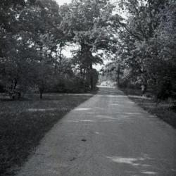
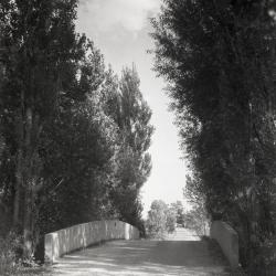
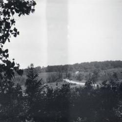
Simonds Road looking north (3.32122)
Date: 1930sType: Photographic image
Description:Simonds road looking north
*located at about 31-HH on Arboretum map/grid
Extent: 1 negative

Simonds Road and road to Lake Marmo, view toward Malus Collection (3.32740)
Date: 1934Type: Photographic image
Description:Simonds Road and road to Lake Marmo, view toward Malus Collection
Extent: 1 negative
Simonds Road bridge over DuPage River before metal railing (3.33577)
Date: 1934Type: Photographic image
Description:Simonds Road bridge over DuPage River before metal railing
Extent: 1 negative
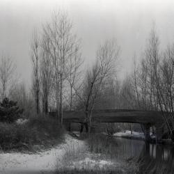
Simonds Road bridge over DuPage River with cement railings looking north (3.33578)
Date: 1930sType: Photographic image
Description:Simonds Road bridge over DuPage River with cement railings as designed by O.C. Simonds looking north
Extent: 1 negative
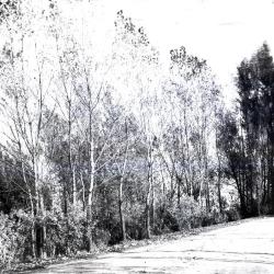
West approach to bridge over DuPage River on Simonds Road (3.33579)
Date: 1930sType: Photographic image
Description:West approach to bridge over DuPage River on Simonds Road
Extent: 1 negative
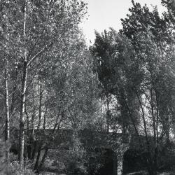
Bridge over DuPage River, looking southeast (3.33581)
Date: 1930 – 1949Type: Photographic image
Description:Bridge over DuPage River, looking southeast
Extent: 1 negative

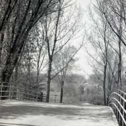
Simonds Road in winter looking southeast to DuPage River bridge (3.33582)
Date: 1925 – 1949Type: Photographic image
Description:Simonds Road in winter looking southeast to DuPage River bridge
Clarence Godshalk's first house in distance
Extent: 1 negative
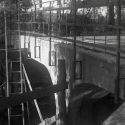
DuPage River bridge, metal railings installation (3.33583)
Date: 1935Type: Photographic image
Description:DuPage River bridge, metal railings installation
Extent: 1 negative
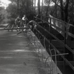
DuPage River bridge, men working on metal railing installation (3.33584)
Date: 1935Type: Photographic image
Description:DuPage River bridge, men working on metal railing installation
Extent: 1 negative
DuPage River bridge with new metal railings (3.33585)
Date: 1935Type: Photographic image
Description:DuPage River bridge with new metal railings
Extent: 1 negative
Looking north from Clarence Godshalk's yard, DuPage River bridge in center (3.33989)
Date: 1920sType: Photographic image
Description:Looking north from Clarence Godshalk's yard, DuPage River bridge in center
Extent: 1 negative

General Information and Guide Map of The Morton Arboretum (3.34267)
Date: 1941Type: Map
Description:Doublesided brochure with general information and a guide map of The Morton Arboretum.
Guide map details Arboretum roads, trails, parking, plant collections, buildings and points of interest. Fifteen areas on the grounds highlighted in the key and identified with circled numbers on the map. Surfaced roads, gravel roads, and paths distinguished on the map by the type of line drawn. Compass showing directions north, south, east, west as well as scale indicator above top center of map.
Reverse side provides general information about the Arboretum, rules and regulations, and information about the Arboretum publication, Bulletin of Popular Information.
Extent: 1 sheet

General Information and Guide Map of The Morton Arboretum (3.34268)
Date: 1942Type: Map
Description:Doublesided brochure with general information and a guide map of The Morton Arboretum.
Guide map details Arboretum roads, trails, parking, plant collections, buildings and points of interest. Vegetation illustrated throughout map. Three stylized trees under compass showing directions north, south, east, west as well as scale indicator above top center of map.
Reverse side provides general information about the Arboretum, rules and regulations, outstanding features, buildings, Arboretum publications, and location.
Extent: 1 sheet

A Guide Map of The Morton Arboretum (3.34269)
Date: 1969Creator: Tyznik, Anthony
Type: Map
Description:A guide map of The Morton Arboretum created by Tony Tyznik in 1969. The background is a dark green with the inner Arboretum being a light green and Arboretum roads highlighted in solid orange and checkered orange lines.
Extent: 1 sheet

Map & Visitor Guide, The Morton Arboretum (3.34271)
Date: 1982 – 1986Type: Map
Description:Double-sided brochure, Map & Visitor Guide for The Morton Arboretum
Map details Arboretum roads, trails, plant collections, buildings and boundaries. Includes photographs of various Arboretum buildings with descriptive information.
Reverse side provides general information about the Arboretum, trails for walking and hiking, driving through the Arboretum, areas and collections of special interest, native plant communities, wildlife at the Arboretum, regulations, facilities and services, and information on membership. A section of the map is enlarged to identify landmarks around the Visitor Center, Administration Building, and Thornhill Education Center.
Extent: 1 sheet
Central European Woods, Morton Arboretum (3.5670)
Date: 1920sCreator: Teuscher, Henry
Type: Plan
Description:Birch, spruce, beech, pine, alder, oak, and larch plantings are shown. The geographic collection is located on the east of Simonds Road in the western portion of the Arboretum.
Extent: 1 sheet
[Planting Plan Along Simonds Road at the DuPage River Bridge] (3.5686)
Date: 1920sCreator: Teuscher, Henry
Type: Plan
Description:Plan shows Joy Morton's initialed approval.
Extent: 1 sheet